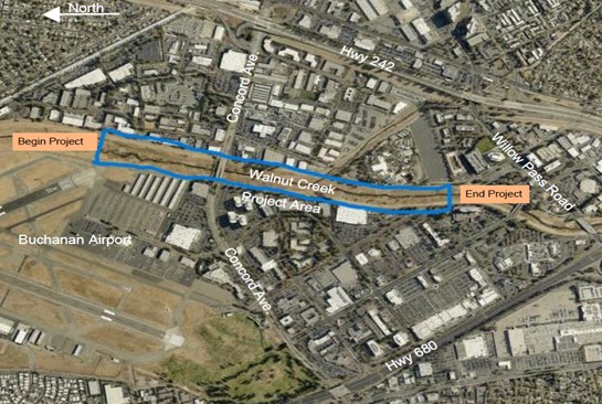
• Home
  • About The Herald
  • Local Agencies
  • Daily Email Update
  • Legal Notices
  • Classified Ads

Contra Costa Herald

News Of By and For The People of Contra Costa County, California

  • Arts & Entertainment
  • Business
  • Community
  • Crime
  • Dining
  • Education
  • Faith
  • Health
  • News
  • Politics & Elections
  • Real Estate

West County: District 1 Open House on Contra Costa Draft General & Climate Action Plans Feb. 21

February 14, 2024 By Publisher Leave a Comment

Casa Abierta sobre el Borrador del Plan General del Condado y el Plan de Acción Climática

At El Cerrito City Hall

By District 1 Supervisor John Gioia

I invite you to join us for an upcoming open house to learn about the Draft Contra Costa County General Plan and Draft Climate Action Plan Update!

When: Wednesday, February 21 from 5:00 – 7:00 pm

Where: El Cerrito City Hall Lobby, 10890 San Pablo Ave., El Cerrito

Learn about proposed land use policies for the unincorporated areas of West County – Kensington, East Richmond Heights, El Sobrante, North Richmond, Rollngwood, Montalvin Manor/Bayview and Tara Hills; and provide input.

Click on my video explaining the importance of participating in the General Plan!

The Draft Contra Costa County General Plan and Draft Climate Action Plan (CAP) 2024 Update are part of the Envision Contra Costa 2040, the County’s plan to address land use, transportation, housing, climate change, environmental justice and other important issues over the next 20 years. They update is available for public review at envisioncontracosta2040.org. (See related article)

Community feedback has been the driving force behind our planning efforts. Now, we invite you to explore our work and ensure it reflects our collective vision for Contra Costa County’s future.

We’ll be taking questions, providing answers, and encouraging you to share feedback in-person or through our online commenting tool.

View the event flyer here.

Thank you, and we hope to see you there!

En Español

¡Lo invito a unirse a nosotros en una próxima jornada de puertas abiertas para conocer el borrador del Plan General del Condado de Contra Costa y el borrador de la actualización del Plan de Acción Climática!

Cuándo: Miércoles 21 de febrero de 5:00 a 7:00 p.m.

Dónde: Vestíbulo del Ayuntamiento de El Cerrito, 10890 San Pablo Ave., El Cerrito

Conozca las políticas de uso de suelo propuestas para las áreas no incorporadas del oeste del condado: Kensington, East Richmond Heights, El Sobrante, North Richmond, Rollngwood, Montalvin Manor/Bayview, Tara Hills; y proporcionar información.

El borrador del Plan General del Condado de Contra Costa y el borrador del Plan de Acción Climática (CAP) 2024 están disponibles para revisión pública en envisioncontracosta2040.org

Los comentarios de la comunidad han sido la fuerza impulsora detrás de nuestros esfuerzos de planificación. Ahora, lo invitamos a explorar nuestro trabajo y asegurarnos de que refleje nuestra visión colectiva para el futuro del condado de Contra Costa.

Responderemos preguntas, brindaremos respuestas y lo alentaremos a compartir sus comentarios en persona o a través de nuestra herramienta de comentarios en línea.

Vea el folleto del evento aquí.

¡Gracias y esperamos verte allí!

Allen D. Payton contributed to this report.

Filed Under: Environment, Government, Growth & Development, Supervisors, Transportation, West County

Public Meeting: Federal review of MTC’s role in the Bay Area Feb. 27

February 12, 2024 By Publisher Leave a Comment

Source: MTC

Every four years, the Secretary of the U.S. Department of Transportation (DOT) must certify that each metropolitan planning organization (MPO) serving a transportation management area (TMA) — a designation by DOT of an urbanized area with a population over 200,000 as defined by the Bureau of the Census or smaller urbanized areas on request by the Governor and MPO — is carrying out the metropolitan planning process in adherence with federal statutes and regulations. The Federal Highway Administration (FHWA) and the Federal Transit Administration (FTA) conduct a review of the metropolitan planning process within each TMA and jointly issue this certification on behalf of the DOT Secretary, in accordance with 49 U.S.C. 5303(k).

The FHWA and the FTA are hosting a public meeting as part of MTC’s certification review. This public meeting is an opportunity for Bay Area residents to directly address FHWA and FTA officials concerning your views on the transportation planning process in the San Francisco–Oakland metropolitan area. Participants can attend in person or via Zoom or submit written comments.

The meeting is scheduled for:

Tuesday, February 27, 2024, from 4:30–5:30 p.m.
Bay Area Metro Center, Yerba Buena Conference Room, First Floor
375  Beale Street, San Francisco, CA 94105
Participate on Zoom

Webinar ID: 863 1915 0671
iPhone One-Tap:

+13462487799,,86319150671# US (Houston)
+12532158782,,86319150671# US (Tacoma)

Join by Telephone (for higher quality, dial a number based on your current location):

+1 408 638 0968 US (San Jose)
+1 669 900 6833 US (San Jose)
833 548 0282 US Toll Free
877 853 5247 US Toll Free

Detailed instructions on participating via Zoom are available at:
mtc.ca.gov/how-provide-public-comment-board-meeting-zoom
Members of the public participating by Zoom wishing to speak should use the “raise hand” feature or dial *9. When called upon, unmute yourself or dial *6. In order to get the full Zoom experience, please make sure your application is up to date.

This public meeting  is part of a review that will assess compliance with federal regulations pertaining to the transportation planning process conducted by MTC, the California Department of Transportation, transit operators and local jurisdictions in the San Francisco–Oakland metropolitan area.

If you are unable to attend the meeting, written comments may be submitted via email to Cert.Review@dot.gov.
Written comments also can be mailed to:

Federal Highway Administration, California Division
650 Capitol Mall, Suite 4-100
Sacramento, CA 95814-4708
Or
Federal Transit Administration, Region  IX
90 Seventh Street, Suite 15-300
San Francisco, CA 94103-6701

請求幫助! | ¡Solicita Ayuda! | Request Assistance!

您是否需要我們協助翻譯其中一份文件的内容? 您是否需要大字體或盲文印刷的書面資料? 您是否需要手語或您所説語言的翻譯協助才能參與活動?
我們可以爲您提供幫助! 請致電 (415) 778-6757和我們聯係。為確保爲您提供適當的安排,請提前三天通知我們。對於TDD或聽障人士,請致電711,加州轉接服務,或 (800) 735-2929(TTY),(800) 735-2922(語音),然後要求轉接至 (415) 778-6700。

¿Necesita que alguno de nuestros documentos sea traducido? ¿Necesita nuestras comunicaciones escritas en letra grande o en Braille? ¿Necesita un intérprete del lenguaje de señas o un intérprete que hable su idiomapara poder participar?
¡Nosotros podemos ayudar! Comuníquese al (415) 778-6757. Necesitamos aviso con tres días de anticipación para proporcionar asistencia razonable. Para personas con discapacidad auditiva o TDD, llame al 711, California Relay Service, o al (800) 735-2929 (TTY) o al (800) 735-2922 (voz) y pida que lo comuniquen al (415) 778-6700.
Do you need one of our documents translated? Do you need written materials in large type or in Braille? Do you need a sign language interpreter or an interpreter who speaks your language in order to participate?
We can help! Please call us at (415) 778-6757. We require three days’ notice in order to provide reasonable
accommodation. For TDD or hearing impaired, call 711, California Relay Service, or (800) 735-2929 (TTY) or (800) 735-2922 (voice) and ask to be relayed to (415) 778-6700.


Filed Under: Bay Area, News, Transportation

65 Bay Area candidates in March 5th primary share vision, values on transportation issues

February 7, 2024 By Publisher Leave a Comment

Only 9 running to represent Contra Costa respond; read the questions and their answers

A coalition of transportation advocacy groups from around the Bay published the results “Transportation Questionnaire” for Bay Area Candidates for Office that are on the March 5th 2024 Ballot which the public can view in its entirety here. People can view it by region at: East Bay; North Bay; Peninsula; San Francisco; and South Bay.

The project, led by Transbay Coalition, SPUR, Seamless Bay Area, San Francisco Transit Riders, Silicon Valley Bike Coalition, and Bike East Bay will help voters across the Bay Area make more informed decisions about candidates for local, state and federal office.

“Candidate’s stances on how to make it easier for people to get around the Bay Area and what needs fixing is essential information for voters,” said Carter Lavin, the project lead at the Transbay Coalition. “Transportation policies impact everyone and every elected official, no matter the office, has the power to make it easier, greener, safer, more affordable, just and accessible for people to get around– or they can make it harder. Voters deserve to know where the candidates vying for their vote stand.”

“To my knowledge, this is the only vetting process that really seeks to demystify where candidates stand on the region’s transportation issues, which is critical given how much public funding goes into transportation and the pivotal moment we are in” said Laura Tolkoff, Transportation Policy Director for SPUR, a public policy nonprofit rooted in the Bay Area.

Candidates were asked the following questions included in the survey:

  1. Which forms of transit and active transportation (bicycling, walking, scooters, wheelchair) do you use on a regular basis and for what types of trips– and why?
  2. Would you seek additional funding for Bay Area transit and what form of funding do you think makes sense?
  3. Public transit in the Bay Area is highly fragmented, with 27 transit agencies, each with different fares, schedules, branding, and customer information. Do you believe it should be a priority for the region to create an well-coordinated transit system? And as an elected leader or potential member of a local transit agency board, would you support state legislation that advances a more integrated, high ridership system, even if it diminishes local control?
  4. Transportation is the largest single source of carbon emissions in California, and in the Bay Area, and the largest share of transportation emissions come from single occupancy vehicles.  What are your top priorities to achieve substantial reduction in transportation-related GHG emissions?
  5. The Bay Area still has road projects under development that would increase Vehicle Miles Traveled (VMT), greenhouse gas emissions, and air pollution.  What decisions would you make about projects that increase VMT and pollution?
  6. Transit priority improvements are proven to make taking the bus faster and more reliable, while also reducing operating costs. Should local governments be able to stop transit priority improvements on local roads?
  7. What do you think are the most important actions that can be taken to make public transit comfortable, accessible, and safe for all communities?
  8. Traffic violence and deaths in California are increasing annually; in 2021, 4,258 people died in vehicle crashes, a 10.7% increase from the prior year. If elected, what will you do to reverse the trend, increase street safety, save lives and reduce injuries in our community?  What policies or specific projects would make the greatest impact?
  9. What do you think are the biggest access and mobility needs for disadvantaged populations in your district, and how would you propose to solve them?
  10. In what circumstances do you support removing parking or repurposing vehicle travel lanes to create safer and more efficient bus, biking, and walking options? How do you propose balancing the demands of different interest groups who may disagree on how streets should be designed?

Contra Costa County Candidates Who Responded

So far, only the following candidates have responded to the questionnaire in the following races:

Assembly District 14 – Margot Smith 2024 Transp Qnr    Buffy Wicks 2024 Transp Qnr

Assembly District 15 – Karen Mitchoff 2024 Transp Qnr  Monica E Wilson 2024 Transp Qnr

Assembly District 16 – Joseph Rubay 2024 Transp Qnr

State Senate District 3 – Jackie Elward 2024 Transp Qnr

State Senate District 7 – Jovanka Beckles 2024 Transp Qnr  Dan Kalb 2024 Transp Qnr

Congressional District 10 – Mohamed Elsherbini 2024 Transp Qnr

No candidates have responded yet in the races for Contra Costa County Supervisor District 5, Assembly District 11, State Senate District 9 nor Congressional District 8.

“Over the next few years, the region faces important decisions about continuing on a path toward convenient, rider-friendly, accessible worldclass public transportation – or taking steps backward. Our elected officials at the local, state and federal levels will make key decisions steering our region on a path toward improvement or into a downward spiral. Voters deserve to know where candidates stand at this pivotal time,” said Adina Levin, Co-Founder and Advocacy Director, Seamless Bay Area.

“With the rise of biking and walking fatalities across the Bay Area, it is more important than ever that voters know where candidates stand in building communities that are joyful, safe, and inclusive” said Justin Hu-Nguyen, Bike East Bay’s  Co-Executive Director of Mobility Justice.

“Public transit is a lifeline for so many people in the Bay Area. Allowing transit agencies to go unfunded would hurt economically disadvantaged and transit-dependent people the worst, leaving thousands of transit riders — including workers, seniors, and people with disabilities — without a reliable way of getting around. It connects folks with everything from food, to healthcare, family, friends and fun. We’re excited to release this questionnaire, which lifts the issues that matter to transit riders, with our other partners in the space. In order to make the Bay Area a more pleasant, affordable, and green place to live, our elected representatives need to center public transit and transit riders in the choices they make for us,” said Dylan Fabris, Community & Policy Manager for San Francisco Transit Riders.

Candidates who have not yet responded can email their answers to info@transbaycoalition.org and the coalition could potentially update their website and include them.

The Transbay Coalition is a grassroots public transportation advocacy group championing bold near-term solutions to the Bay Area’s regional transportation challenges. Learn more at www.transbaycoalition.org.

Allen D. Payton contributed to this report.

Filed Under: Bay Area, News, Politics & Elections, Transportation

MTC, ABAG approve Plan Bay Area 2050+ Draft Blueprint Strategies and Growth Geographies

January 30, 2024 By Publisher Leave a Comment

Source: Plan Bay Area 2050+

Include non-transit transportation, environment, housing and economy strategy refinements

The Joint Metropolitan Transportation Commission (MTC) Planning Committee with the Association of Bay Area Governments (ABAG) Administrative Committee on Jan. 12, 2024 approved the revised Plan Bay Area 2050+ Draft Blueprint strategies and Growth Geographies.  This action enables staff to further study the strategies’ performance in meeting critical regional goals for an affordable, connected, diverse, healthy and vibrant Bay Area for all. Staff are aiming for adoption of the Plan Bay Area 2050+ Final Blueprint in summer 2024.

Given Plan Bay Area 2050’s solid foundation of 35 strategies, the Draft Blueprint phase for Plan Bay Area 2050+ is focusing on making targeted refinements to select plan strategies. These refinements reflect Plan Bay Area 2050’s implementation progress, the post-pandemic planning context and insights gathered during engagement with the public and partners in summer 2023.

What is the Plan Bay Area 2050+ Blueprint?

The Plan Bay Area 2050+ Blueprint will integrate strategies across the four elements of the plan — the economy, the environment, housing and transportation — to create a more equitable and resilient future for all.

Beginning in summer 2023 and wrapping up in late 2024, staff will develop the Blueprint over two phases: the Draft Blueprint and the Final Blueprint. Given Plan Bay Area 2050’s solid foundation of 35 strategies, the Draft Blueprint phase for Plan Bay Area 2050+ will focus on making targeted refinements to select plan strategies.

What are Growth Geographies?

Priority Development Areas — Places nominated by local governments served by transit and planned for new homes and jobs at densities necessary to support effective transit service.

Priority Production Areas — Industrial areas of importance to the regional economy and local communities that support middle-wage jobs.

Transit-Rich Areas — Places near rail, ferry or frequent bus service that were not already identified as Priority Development Areas.

High-Resource Areas — State-identified places with well-resourced schools and access to jobs and open space.

Staff previously shared proposed Draft Blueprint strategy refinements in October and November 2023, detailing which of Plan Bay Area 2050’s 35 strategies were likely to see major, minor or no changes in Plan Bay Area 2050+. This month, the MTC and ABAG committees approved moving forward with revisions for further study and analysis, including:

  • Non-transit transportation strategy refinementsfocused on prioritizing equity considerations, adapting to tighter fiscal constraints, promoting active transportation and safety, and expanding pricing strategies;
  • Environment strategy refinementsfocused on further reducing greenhouse gas emissions and proactively adapting to climate change; and
  • Housing and economy strategy refinementsfocused on addressing pressing challenges of housing affordability, homelessness and access to opportunity.

At this time the Draft Blueprint only includes a handful of modified transportation strategies, pending the development of a fiscally constrained Transportation Project List, which will integrate recommendations from the ongoing parallel Transit 2050+ effort. The complete suite of revised transportation strategies will be integrated as part of the Final Blueprint in summer 2024.

The Joint ABAG and MTC Committee also approved targeted updates to the Growth Geographies that were adopted as part of Plan Bay Area 2050. Growth Geographies are places that Plan Bay Area prioritizes for future homes, jobs, services and amenities and serve as a component of the plan’s housing and economy elements. Specifically, draft Growth Geographies for Plan Bay Area 2050+ will include five new Priority Development Areas (PDAs) and 16 modified existing PDAs nominated by local Bay Area jurisdictions; reflect up-to-date information on transit service, natural hazards and demographics; and integrate areas subject to MTC’s revised Transit Oriented Communities Policy.

The Draft Blueprint approval comes six months after MTC and ABAG kicked off the limited and focused update to Plan Bay Area 2050. In November 2023, staff shared progress-to-date with policymakers, including findings from the first round of engagement, core planning assumptions, the draft Regional Growth Forecast, a financial needs and revenue analyses and proposed strategy refinements.

The next round of public and partner organization engagement activities, which will inform the development of the Plan Bay Area 2050+ Final Blueprint, is planned to begin in spring 2024. MTC and the ABAG Executive Board are expected to approve Final Blueprint strategies in summer 2024.

Learn more about the Plan Bay Area 2050+ Draft Blueprint strategies and Growth Geographies. For additional technical resources, please visit the Plan Bay Area 2050+ Draft Blueprint Documents page on our website.

Filed Under: Bay Area, Business, Economy, Government, Homeless, Industry, Jobs & Economic Development, News, Transportation

Bay Area transit to take on a whole new look

January 29, 2024 By Publisher Leave a Comment

Source: MTC

Unified mapping and wayfinding features Golden Yellow, Sky Blue, Dark Blue

By John Goodwin & Gordon Hansen, Metropolitan Transportation Commission

Bay Area transit’s ongoing transformation into a more connected, more efficient and more customer-focused mobility network today took another big step forward as transit agency and MTC staff at the January meeting of the Bay Area’s newly formed Regional Network Management Council unveiled design protoypes for a common set of signs to be used by all agencies at all locations — from individual bus stops to major hubs where multiple systems connect. These prototypes will be installed later this year at the El Cerrito del Norte BART station, the Santa Rosa Transit Mall and the nearby Santa Rosa SMART station.

To establish and reinforce a common identity for all Bay Area transit services, the new signage employs a three-color palette of golden yellow, sky blue and dark blue; as well as simple icons to identify service by trains, buses or ferries. These icons are larger and more visually prominent than the logos of the individual agencies providing the services at each location. The modal icons and the three-color palette will be extended to a new mobile-friendly website to which passengers can connect via QR codes at each bus stop, train station or ferry terminal, providing real-time information along with accessibility features such as audio descriptions and language translation.

“The Mapping and Wayfinding initiative is a brilliant example of regional cooperation,” said MTC Chair and Napa County Supervisor Alfredo Pedroza. “Putting customers’ interests first is the cornerstone of our Transit Transformation Action Plan to increase ridership by making transit faster, cleaner, more comfortable, more convenient and easier to navigate.”

More than 90 percent of Bay Area residents polled by MTC in 2021 identified uniform and easy-to-use transit maps and signage as an important priority for improving the region’s transit network. MTC’s Operations Committee in 2022 approved a contract with Applied Wayfinding Inc. to develop a single mapping and wayfinding system for use by all Bay Area transit agencies. Applied has completed similar projects in London; Toronto; Seattle; Cleveland; Vancouver, B.C.; and elsewhere. The design concepts presented today incorporate comments and recommendations from more than 1,000 Bay Area residents — including transit riders and nonriders, people with limited English proficiency and people with disabilities — who participated in MTC-sponsored surveys, workshops and focus groups. New transit signage will include tactile and Braille elements.

The golden yellow in the three-color palette developed by transit agencies, MTC and the design contractor was chosen to represent the Bay Area’s sunshine and golden hills, with the light blue representing clear skies and the dark blue representing San Francisco Bay, lakes, rivers and other bodies of water. MTC and its partners will invite Bay Area residents and visitors alike to share their thoughts about the newly designed transit signs and digital wayfinding tools once the prototypes — which have not yet been fabricated — are installed at the Santa Rosa and El Cerrito locations.

Design prototypes for a consistent set of transit maps will be presented to the Regional Network Management Council later this year. The Council includes top executives from MTC, the San Francisco Municipal Transportation Agency, BART, AC Transit, the Santa Clara Valley Transportation Authority (VTA), Caltrain, SamTrans and the Golden Gate Bridge, Highway and Transportation District as well as three general managers representing all other transit agencies serving Bay Area communities.

MTC is the transportation planning, financing and coordinating agency for the nine-county San Francisco Bay Area.


Filed Under: BART, Bay Area, News, Transportation

MTC to seek legislature’s approval to place Bay Area Transportation tax measure on 2026 ballot

January 25, 2024 By Publisher Leave a Comment

Photo by MTC.

To generate at least $1 to $2 billion annually; priorities include transit, safer streets and roads, resilience

Commissioners considering a variety of tax options

By John Goodwin & Rebecca Long, Metropolitan Transportation Commission

The Metropolitan Transportation Commission (MTC) on Wednesday, Jan. 24, 2024 voted to pursue legislation in Sacramento this year that would enable Bay Area voters to consider a transportation revenue measure as early as November 2026.

The proposed measure aims to advance a climate-friendly Bay Area transportation system that is safe, accessible and convenient for all. This includes preserving and enhancing public transit service; making transit faster, safer and easier to use; repairing local streets and roads; and improving mobility and access for all people, including pedestrians, bicyclists and scooter and wheelchair users.

The vote was approved unanimously by all members present. There are 21 commissioners with three non-voting members. Oakland Mayor Sheng Tao and San Jose Mayor Matt Mahan who are voting members were both absent during the vote.

State Sen. Scott Wiener of San Francisco earlier this month introduced what is known as a spot bill that will be used as the vehicle for authorizing placement of the proposed measure on a future ballot in each of the nine Bay Area counties. The first opportunity to amend Wiener’s Senate Bill 925 will be in mid-February.

While the Commission has not yet identified a revenue source for the proposed measure, MTC Chair and Napa County Supervisor Alfredo Pedroza noted that he and his colleagues are considering a wide range of options.

“Voters traditionally have supported transportation through bridge tolls or sales taxes. Bridge tolls are not an option in this case and we think it’s smart to look at more than a regional sales tax. We’re proposing a few options so we have enough flexibility and enough time to get it right.”

Tax Options & Projected Revenue

Legislators, and MTC staff and commissioners, will consider several options for generating revenue. These may include a sales tax, an income tax, a payroll tax, a square footage-based parcel tax, a Bay Area-specific vehicle registration surcharge with tiered rates based on the value of the vehicle or a regional vehicle-miles traveled charge (VMT) charge subject to prior adoption of a statewide road usage charge not sooner than 2030.

MTC staff recommend raising at least $1 billion to $2 billion per year for robust investments in safe streets and other capital improvements, to improve and expand transit service, and to help Bay Area transit agencies operate their services.

Goals of the Regional Transportation Measure

The revenue measure’s core goal is to advance a climate-friendly transportation system in the Bay Area that is safe, accessible and convenient for all. Focus areas include:

  1. Protect and enhance transit service. Ensure that current resources are maintained and used effectively; and enhance service frequency and areas served.
  2. Make transit faster, safer and easier to use. Create a seamless and convenient Bay Area transit system that attracts more riders by improving public safety on transit; implementing the Bay Area Transit Transformation Action Plan; and strengthening regional network management.
  3. Enhance mobility and access for all. Make it safer and more accessible for people of all ages and abilities to get to where they need to go. Preserve and improve mobility for all transportation system users, including people walking, biking and wheeling.

Proposed Expenditure Categories

  1. Transit transformation: sustain, expand and improve transit service for both current and future riders; accelerate customer-focused initiatives from the Bay Area Transit Transformation Action Plan and other service improvements that are high priorities for Bay Area voters and riders; and help fund the transition to zero-emission transit.
  2. Safe streets: transform local streets and roads to support safety, equity and climate goals, including through pothole repair, investments in bicycle/pedestrian infrastructure, safe routes to transit and other safety enhancements.
  3. Connectivity: fund mobility improvements that close gaps and relieve bottlenecks in the existing transportation network in a climate-neutral way.
  4. Climate resilience: fund planning, design and/or construction work that protects transportation infrastructure and nearby communities from rising sea levels, flooding, wildfires and extreme heat.

Transportation Measure Highlights

This measure reflects feedback from Commissioners, key legislative leaders and other stakeholders, including:

  • Improving transit coordination by strengthening MTC’s role as regional transit network manager;
  • A focus on Bay Area Transit Transformation Action Plan (TAP) action items and other customer facing policies that would benefit from a regional approach, such as ambassadors to assist riders and support a safe atmosphere;
  • Flexibility in the amount of revenue requested, as well as the way that funding could be generated;
  • Flexibility in spending priorities as the region’s needs evolve with time; and
  • The “North Star” vision statement, which includes greenhouse gas emission-reduction tools, such as:
    • A Transportation Demand Management mandate that encourages Bay Area employees to commute to work in ways other than driving to work alone; and
    • A limitation on how money could be spent on highway-widening projects.

Just as MTC commissioners have proposed a range of tax options, so too have they identified multiple expenditure categories.

“We recognize that we’ll be asking voters to take on a heavy lift,” acknowledged Pedroza. “The big lesson from COVID is the need to transform both our transit network and the way we pay to operate it. But we also need to transform our local streets and roads to fix potholes and make the roads safer for walking and biking. We need to improve connectivity and do it in a way that doesn’t encourage people to drive more. And we need to make our transportation infrastructure more resilient to rising sea levels, flooding, wildfires and extreme heat.”

Measure Vision Statement

The commissioners also adopted the following Vision Statement for the measure: “The Bay Area needs a world-class, reliable, affordable, efficient and connected transportation network that meets the needs of Bay Area residents, businesses and visitors while also helping combat the climate crisis; a public transit network that offers safe, clean, frequent, accessible, easy-to-navigate and reliable service, getting transit riders where they want and need to go safely, affordably, quickly and seamlessly; local roads are well maintained; and transit, biking, walking and wheeling are safe, convenient and competitive alternatives to driving; enhancing access to opportunity, lowering greenhouse gas emissions, strengthening the region’s economy and improving quality of life.”

To learn more about the proposed tax measure click, here. To read the supporting documents considered by the Commissioners click, here.

MTC is the transportation planning, financing and coordinating agency for the nine-county San Francisco Bay Area.

Allen D. Payton contributed to this report.


Filed Under: Bay Area, Legislation, News, State of California, Taxes, Transportation

San Pablo Dam Road work in El Sobrante begins Monday, Jan. 21

January 19, 2024 By Publisher Leave a Comment

Source: CCC Public Works

By Kelly Kalfsbeek, Community & Media Relations Coordinator, PIO, Contra Costa County Public Works
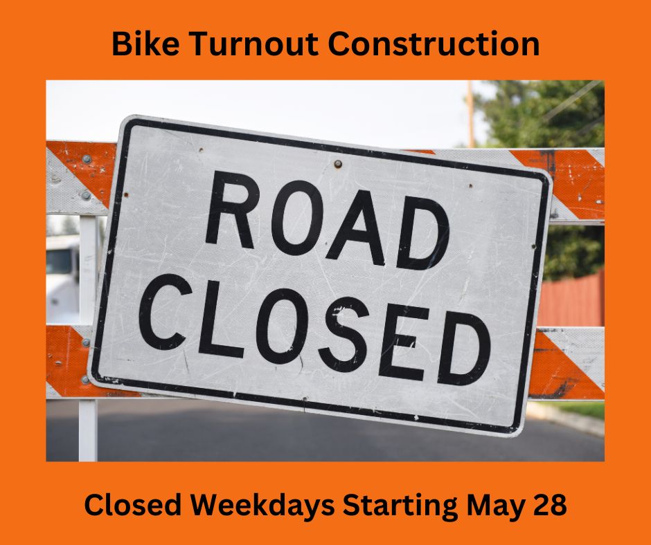
Contra Costa County Public Works will be upgrading traffic signal hardware to improve pedestrian safety at nine (9) intersections on San Pablo Dam Road between El Portal Drive and Castro Ranch Road. Work will begin on Monday, January 22, 2024, and continue through Friday, June 21, 2024, barring unforeseen circumstances. Work will take place between 8:30 a.m. and 4:00 p.m., Monday through Friday (excluding holidays), weather permitting. Restrictions will be in place to minimize impacts to drivers during commute hours.

Funding for this project is provided by Gas Tax (SB1 Road Repair and Accountability Act) and Highway Safety Improvement Program (HSIP). For more information regarding this work, visit: www.contracosta.ca.gov/San-Pablo-Dam-Road-and-Bailey-Road-Signal-Hardware-Upgrades

About Contra Costa County Public Works Department:

Contra Costa County Public Works Department (CCCPWD) maintains over 660 miles of roads, 150 miles of streams, channels, and other drainage and over 150 County buildings throughout Contra Costa County. CCCPWD provides services such as Parks and Recreation, Sandbag Distribution and Flood Control throughout unincorporated areas of Contra Costa County.  CCCPWD operates two airports, Buchanan Field Airport in Concord, and Byron Airport in Byron. For more information about CCCPWD, please visit us at: www.cccpublicworks.org. Follow us on Facebook, Instagram and X @cccpublicworks.


Filed Under: Construction, News, Transportation, West County

Bikes now allowed on escalators at BART

January 9, 2024 By Publisher Leave a Comment

Screenshots source: BART

BART is going all in on bikes! As of January 1, 2024, bikes are allowed on most of the escalators throughout the BART system to help make it easier for people to bring their bikes on board the train.

This change was approved by the BART Board of Directors at the request of Director Rebecca Saltzman. The vote authorizes further changes to BART’s bike rules, including allowing bikes on all train cars except the first car (bikes were previously banned from the first three cars during commute times), and allowing bicyclists to secure bikes on the train using the bike lean bar and straps, instead of holding them.

The bike rules were last changed 10 years ago, when BART ended the ban on bikes on BART during commute hours. Over the last decade, longer and heavier bicycles, such as e-bikes and cargo bikes, have soared in popularity.

“Carrying bikes up and down stairwells can be difficult and not all bikes fit in our elevators,” said BART Director Rebecca Saltzman. “Updating our rules will make BART easier to use for cyclists and families bringing bikes on the train. Bikes play an important role in getting people out of their cars and on public transit and these updated rules encourage environmentally friendly multimodal travel options.”

BART encourages riders to use their best judgment when utilizing system escalators and elevators because individual bikes vary in size and weight.

BART is releasing a new video detailing safety tips for bringing bikes on escalators in the BART system.

See updated Bikes on BART rules here:

*Bikes will remain banned from BART’s ten narrow escalators located at the following three stations: 19th Street Oakland, Antioch and Oakland Airport Connector

Bike + Transit Trips

BART’s Trip Planner offers multi-modal, end-to-end itineraries for bike + transit trips. It features customizable bike speed options including an option for e-bikes (select the settings/tool icon to customize your options). BART’s Trip Planner includes results for more than 30 transit systems in the Bay Area such as bus service, ferries, cable cars, and regional train systems.

BART’s Trip Planner is available on web, mobile, and the official BART app. The BART app also offers station information, including information on secured bike parking.

Elevator Dimension Guid

BART also offers this Elevator Dimension Guide to assist cyclists in navigating BART elevators. It outlines the dimensions of each elevator in the system including measurements of the door, width, length, and diagonal space across the floor. As always, use your best judgment when utilizing system elevators because individual bikes and elevators vary in size.

Filed Under: BART, News, Transportation

New BART schedule with minor changes effective January 15

January 6, 2024 By Publisher Leave a Comment

Get customized notifications with the BART app

By Bay Area Rapid Transit District

Some departure times will shift by a few minutes, and we encourage riders to check the schedule before January 15th to see if their trip is impacted.

BART’s Trip Planner has been updated for trips beginning January 15, 2024, and PDF timetables are available here.

The Official BART App offers customized in-app notifications about BART service and news.

Riders can personalize what type of information they get through the app based on when and where they ride BART and what information they care most about.

For example, you can select service advisories for your line and direction of travel and specific times of day. Or you can get real time departures pushed as notifications for the 15 minutes before arriving to a station on the days you ride.

To turn on these features, select the person icon in the upper-right, then select “Notification Settings” and starting adding what you want. This is a great option for people who don’t want to subscribe to text/email alerts or for people who remain on Twitter (X) only for BART Service Advisories.

We also made it easier to pay for parking with the new Tap-and-Go feature on the app that allows customers to pay for parking with just one tap. Check it out!

Filed Under: BART, News, Technology, Transportation

Investigation shows human error caused BART train derailment, fire

January 4, 2024 By Publisher Leave a Comment

Two cars of the eastbound Antioch line BART train derailed Monday morning, Jan. 1, 2024. Photo by Allen D. Payton

Crossed over to opposite track; some riders self-evacuated

By BART

While the investigation of the January 1, 2024, derailment and fire just east of the Orinda Station continues, BART is providing an update on what occurred and next steps.

Condition of track equipment

That section of track where the derailment occurred, including the interlocking, was recently replaced and was in good operating order. BART’s train control system is being modernized as part of implementing Communications Based Train Control, a major rebuilding project underway.

Timeline of What Happened

At 8:45am on Monday, January 1, 2024, the computer system that monitors and manages BART tracks experienced a localized loss in communication with a field device specific to an area near Orinda Station, including the track interlocking located between Orinda and Lafayette stations. When this occurs, the Operations Control Center does not receive a status indication of route alignments in the area and track positions cannot be controlled remotely. The computer and communication system fails in a safe mode and there are procedures in place to continue to provide train service while crews troubleshoot the loss of computer communication. The system had been operating at the start of revenue service and one train had already travelled eastbound through the area.

At 8:50am the Operations Control Center instructed the train operator of an approaching eight-car Antioch bound train to manually align the route at the interlocking. The route was to be straight through. The train operator left the cab to align the track route. PA announcements were made to riders on board about the delay. The train operator confirmed with the control center they had set the track for a straight through alignment. The control center instructed them to drive the train in manual mode through the area.

Once moving, the train operator reported to the control center the train was crossing over to the opposite track, which was not the correct alignment. In response the control center held all trains in the area and instructed the train operator to move from the Antioch end of the train to the SFO end of the train and to move the train in the SFO direction to clear the interlocking area of the track and correctly align the route for straight through movement. The train operator walked to the other end of the train and moved it in manual mode in the SFO direction. Two cars derailed under slow speed causing electrical arcing, smoke, and flames. Some riders immediately started to self-evacuate by using the emergency door release.

At 9:05am the train operator reported to the control center they believed the train had derailed. The train operator then began to sweep the train, walking through each car to tell people to evacuate. The operator reported the smoke and flames to the control center and advised that people had already started evacuating.

Orinda Police were first to arrive on scene and helped evacuate all riders safely and Orinda Fire Department extinguished the flames.

By 9:23am, the control center was told all riders on board, estimated to be about 100-150 people, had been safely evacuated from the train.

Next Steps

The investigation into the derailment continues. BART has 60 calendar days from the date of the incident to provide a report to the California Public Utilities Commission (CPUC). Until the CPUC accepts and closes the report, the incident is considered “under investigation”, until such time, the report is unavailable to the public.

1/2/24 4:45am Update: Normal Yellow line service will run today following overnight repairs and safety inspections. The headline for this story has been changed to reflect this update.

1/1/24 9:30pm Update:

The incident train is now moving towards the yard. Crews are working on repairs. We will be using our tamper vehicle to surface the track area, pounding down the rocks/ballast. The good news is there was no damage to track switches which would have required more extensive repairs.

The bus bridge will remain in effect through the end of service tonight. Crews will work to make repairs and inspect the tracks this evening and overnight. We hope for full normal service between Walnut Creek and Rockridge tomorrow.

7pm Update:

The crane has successfully re-railed both impacted cars. We will now couple the incident cars with others to tow them out of the way.  Track crews have already begun making repairs to damaged sections of the track so we are hopeful to have, at minimum, single tracking train service through the area for morning service. It could be full normal service depending on progress made.

4:40pm Update:

The crane arrived on scene.

4pm Update:

The two lanes on Eastbound Highway 24 are now closed and crane is enroute for placement.

See remainder of timeline and more photos, here.

Allen D. Payton contributed to this report.

Filed Under: BART, Lamorinda, News, Transportation

  • « Previous Page
  • 1
  • …
  • 8
  • 9
  • 10
  • 11
  • 12
  • …
  • 32
  • Next Page »
Deer-Valley-Chiro-06-22

Copyright © 2026 · · Contra Costa Herald · All Rights Reserved