• Home
  • About The Herald
  • Local Agencies
  • Daily Email Update
  • Legal Notices
  • Classified Ads

Contra Costa Herald

News Of By and For The People of Contra Costa County, California

  • Arts & Entertainment
  • Business
  • Community
  • Crime
  • Dining
  • Education
  • Faith
  • Health
  • News
  • Politics & Elections
  • Real Estate

Construction for Deer Valley Road Traffic Safety Improvements Project continues through Nov. 20

September 21, 2026 By Publisher Leave a Comment

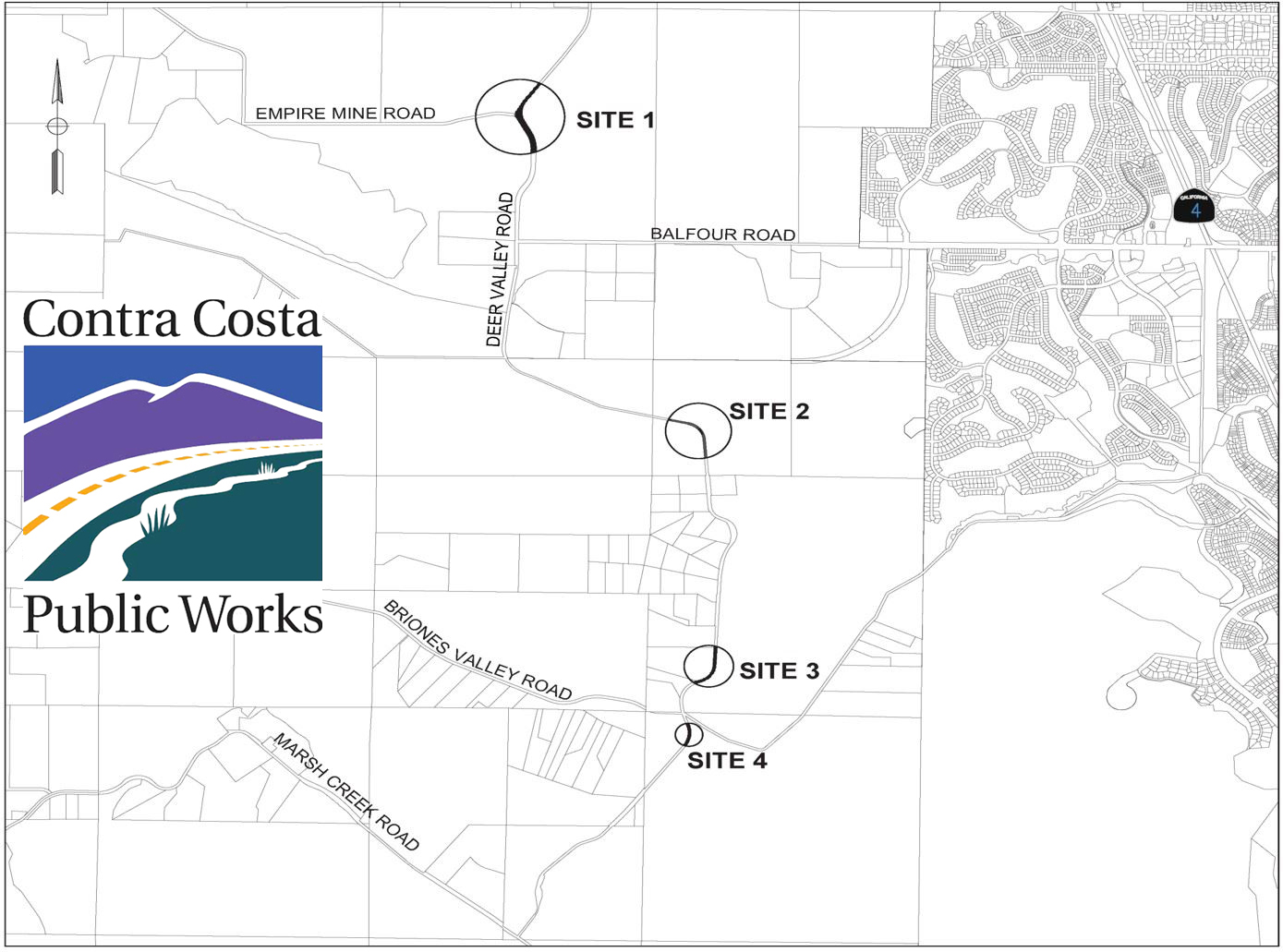
Work Area Map. Source: CCC Public Works

By Kelly Kalfsbeek, Community & Media Relations Coordinator, PIO, Contra Costa County Public Works Department

Antioch and Brentwood, CA – Contra Costa County Public Works will perform road traffic safety improvements at four sites along Deer Valley Road between Empire Mine Road and Marsh Creek Road, from Tuesday, September 8, 2026, through Friday, November 20, 2026, barring unforeseen circumstances. Work will occur between 7:00 a.m. and 5:00 p.m., Monday through Friday, excluding holidays, weather permitting.

Traffic control will be used at each site with restrictions in place to minimize impacts during commuting hours. Message boards will alert drivers to the work. Drivers should expect delays through the work zones and consider alternative routes during working hours.

The project is intended to enhance safety at four locations on Deer Valley Road. Funding for this project is provided by the Federal Highway Safety Improvement Program (HSIP) and Local Gas Tax SB1. For more information about this project, visit www.contracosta.ca.gov/Deer-Valley-Road-Traffic-Safety-Improvements

About Contra Costa County Public Works Department:

The Contra Costa County Public Works Department (CCCPWD) is responsible for the maintenance and operation of over 650 miles of roads, 79 miles of streams and channels, and over 150 County buildings. CCCPWD services include parks and recreation, sandbag distribution, flood control, road and facilities maintenance, and storm water management. CCCPWD operates two airports, Buchanan Field Airport in Concord and Byron Airport in Byron. For more information about CCCPWD, please visit us at: www.cccpublicworks.org.

Filed Under: Construction, East County, News, Transportation

Open-Road Tolling on Bay Area bridges to debut next year at Richmond-San Rafael Bridge

September 21, 2026 By Publisher Leave a Comment

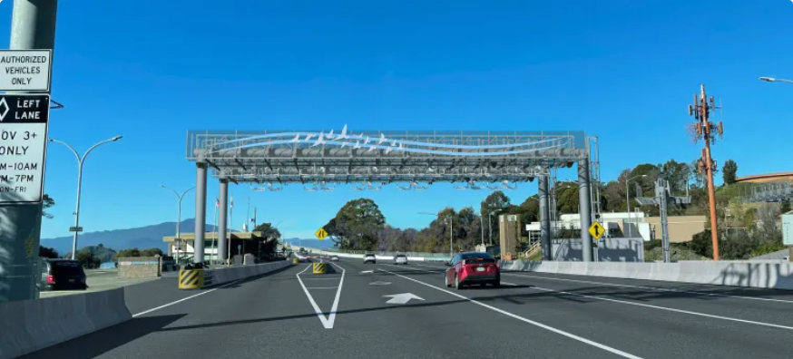
Rendering of planned future Open-Road Tolling toll gantry at the Richmond-San Rafael Bridge toll plaza. Source: Kimley Horn and Associates

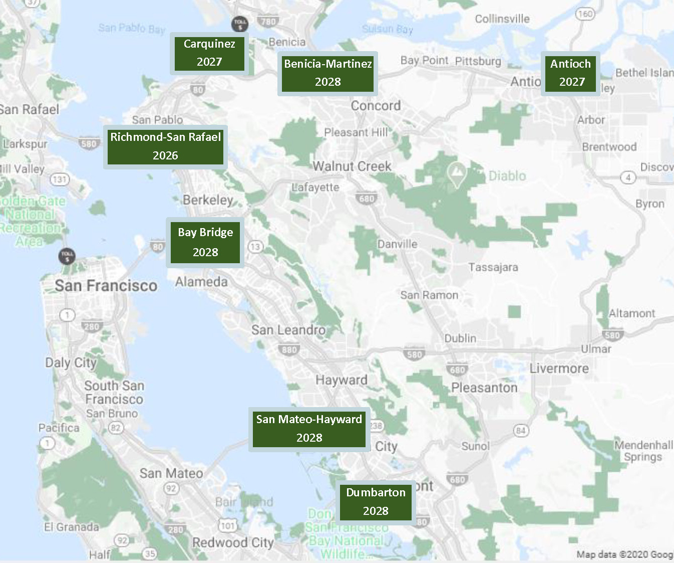
Then expand to Antioch, Benicia-Martinez and Carquinez Bridges in 2027-28; San Francisco-Oakland Bay Bridge, San Mateo-Hayward and Dumbarton Bridges in 2028

Offers high-speed toll collection system; see how an ORT gantry works

By Bay Area Toll Authority

Acting Caltrans District 4 Director and Bay Area Toll Authority (BATA) Commissioner Doanh Nguyen reminds drivers that the toll booths at the Bay Bridge and other state-owned toll bridges will soon be a thing of the past. “The transition to open-road tolling already is underway, with the new system set to debut next year at the Richmond-San Rafael Bridge.”

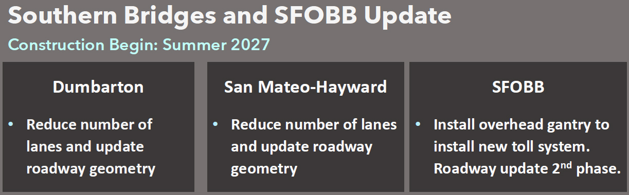
Open Road Tolling (ORT) Program will streamline the driver experience when the toll booths are removed from the seven state-owned toll bridges which currently use All-Electronic Tolling (AET). They will, over time, be converted to ORT.

Why Do We Need the Open Road Tolling (ORT) Program?

The ORT Program will replace the current, aging toll system with newer “toll gantry” technology that will be optimized to process all tolls electronically.

These days, it is not necessary for drivers to stop at toll booths to pay the toll. The ORT Program will remove the toll booths and update the roadway through the toll plaza area, improving safety and highway operations.

Project Benefits

The implementation of ORT will result in more efficient tolling, increased safety at toll plazas and provide a consistent regional experience to Bay Area travelers. Implementing ORT has also been shown in other regions to improve traffic flow and reduce vehicle emissions.

What’s a Toll Gantry?

A toll gantry is an overhead structure with mounted toll readers.

Bay Area Express Lanes use gantries above part of the roadway. In the former toll plazas, the ORT Program will install gantries that cross the entire roadway.

In the illustration at the top of this page, a conceptual toll gantry design is shown at the Richmond-San Rafael Bridge. A The toll plaza has been removed and replaced with toll equipment centered over the lanes.

ORT Toll Gantry illustration. Source: BATA

How Does ORT Work?

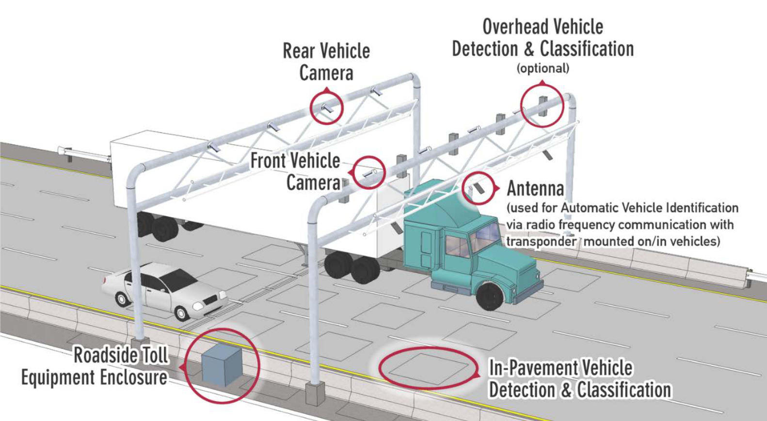
The ORT toll system is a roadside system that detects vehicle information as drivers pass through the toll zone.

A typical ORT roadside system is shown in the figure above.  Overhead cameras, antennae and associated toll equipment are mounted on gantries that span the entire width of the roadway. This equipment captures toll tag and license plate information. Inductance loops are embedded in the pavement and centered on the travel lanes. These loops are used to count the number of axles to assign the right toll rate. The Roadside Toll Equipment Enclosure houses computer processors that package the pieces of information into a single toll transaction. This data is transmitted to the FasTrak Customer Service Center to collect the toll from customers

Construction Period

Construction began in spring 2026 on the Richmond-San Rafael Bridge, the first of the Bay Area’s state-owned bridges to convert to open road tolling.

Before, during and after construction, the collection of tolls will be seamless to the customer. Customers will continue to be able to use their FasTrak toll tag or use their license plate to get an invoice in the mail. While this program will shift the location where tolls are collected from the traditional toll plaza to a gantry over the road, the toll collection process is unchanged.

Map of the Bay Area including San Francisco and the East Bay, showing the location of the seven bridges that are part of the ORT program (Antioch, Benicia-Martinez, Carquinez, Richmond-San Rafael, San Francisco-Oakland Bay Bridge, San Mateo-Hayward and Dumbarton Bridges). Source: BATA

How Do Drivers Pay Tolls?

Toll payment options will be no different under the ORT Program. Drivers can set up a FasTrak account or a Pay By License Plate account to pre-pay tolls. Vehicles without pre-paid accounts will receive an invoice in the mail. A FasTrak toll tag in the designated HOV lane with the required occupancy is required to receive HOV discounts. For more information visit the FasTrak website.

No More Cash Collection

The toll plazas in use today were designed for both cash and electronic payment.

In response to the COVID-19 pandemic, Governor Newsom removed the cash toll booth collectors from the toll plazas on March 21, 2020. This is a permanent change, so there will be no more cash collection at Bay Area toll booths. This effectively changed the toll collection system to operate as an all-electronic system.

Source: BATA

Notice of Exemption for Antioch, Benicia-Martinez & Carquinez Bridges

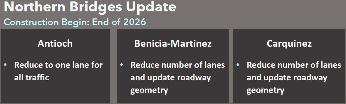
In September 2025, a Notice of Exemption was issued by the Bay Area Toll Authority (BATA) on the California Environmental Quality Act website for the ORT Conversion Northern Bridges Project specifically for the Antioch Bridge, Benicia-Martinez Bridge and Carquinez Bridge toll plazas. The project would replace existing toll booths with new toll gantries, which will serve the same purpose and capacity as the toll booths without expanding the use of existing highways or streets, nor create additional automobile lanes.

BATA, in coordination with the California Department of Transportation (Caltrans), proposes Open Road Tolling (ORT) systems at the Antioch Bridge (State Route-160 [SR-160]), Benicia-Martinez Bridge (Interstate 680 [I-680]), and Carquinez Bridge (Interstate 80 [I-80]) toll plazas in Contra Costa and Solano counties.

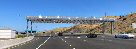
Rendering and photo of the proposed toll gantry at Carquinez Bridge with toll booths removed. Source: BATA

The purpose of the project is to replace aging tolling system infrastructure to improve operational efficiency through bridge toll plazas and improve safety by eliminating the need to pass through existing toll booths. The project is needed to address operational and safety deficiencies for vehicles traveling through the Antioch Bridge, Benicia-Martinez Bridge, and Carquinez Bridge toll plazas.

The existing toll collection system is aging and needs to be replaced. The existing toll collection booths and other civil infrastructure are physical barriers that act as fixed objects within the travel way of the road. The existing fanning and merging of travel lanes near the toll plazas increase the potential for collisions.

Rendering and photo of proposed Antioch Bridge toll plaza with no toll booths and new overhead gantry. Source: BATA

The proposed project would remove and replace existing toll booths, toll equipment, and canopies with ORT systems at the Antioch Bridge, Benicia-Martinez Bridge, and Carquinez Bridge toll plazas. This includes the construction of new ORT gantries and the installation of toll equipment buildings along SR-160, I-680, and I-80. Northbound I-680 and eastbound I-80 would be restriped to four general purpose lanes and one high-occupancy vehicle (HOV) lane through the toll plazas. Northbound SR-160 would be restriped to one lane through the toll plaza. Entrance and exit ramps to and from toll administration buildings and parking lots would be modified. Existing roadway signs would be removed, replaced, or relocated at all three bridge locations, as needed.

BATA’s Toll Policy will provide toll discounts to HOVs with FasTrak® Flex tag. All project activities are within State right-of-way, except for minor widening on the maintenance ramp for Bridgehead Road, which lies within City of Oakley right-of way. Construction is planned to begin in 2026 and is anticipated to take approximately 20 months.

Source: BATA

Public Comment

Staff updates on the program will be provided during BATA Oversight Committee meetings. Members of the public are invited to comment during these meetings.

Comments and questions may also be directed to info@bayareametro.gov with the subject line “ORT Webpage Comment.”

Allen D. Payton contributed to this report.
Filed Under: Bay Area, Finances, News, Taxes, Transportation

Bay Bridge Forward commute initiative to reduce traffic in region’s most congested corridor

September 17, 2026 By Publisher Leave a Comment

Source: MTC

A set of investments, projects and strategies to improve efficiency, reduce delays and move more people and buses across the most-traveled bridge in the Bay Area.

By Metropolitan Transportation Commission

The San Francisco-Oakland Bay Bridge (Bay Bridge) corridor is a vital lifeline for commuter and business travel to and from the City of San Francisco and the East Bay.  It is consistently ranked the most congested corridor in the region. Severe traffic congestion occurs on the approaches to the bridge, especially in the morning commute hours. Vehicles spend more hours delayed approaching the Bay Bridge than on all the other Bay Area east-west crossings combined.  At times, this congestion prevents high-occupancy vehicles (HOVs) and buses from accessing the existing by-pass lanes at the toll plaza – and is worse than the congestion on the bridge itself.  At the same time, high rates of people driving alone and lower transit ridership means that more than half of the seats in vehicles crossing the Bay Bridge are empty.

The Bay Bridge Forward Program proposes solutions that would increase the number of people moving through the area by filling empty seats. This would improve operations and reduce congestion without hefty capital investments. Bay Bridge Forward includes a suite of projects to: improve transit travel time and reliability; promote carpooling and transit ridership; increase the number of people who can move through the corridor (person throughput); and reducing greenhouse gas emissions.

Project 6 – Interstate 80, Bay Bridge & Carquinez Bridge HOV Lane Hours of Operation

Source: MTC

Part of the Bay Bridge Forward commute initiative, the Interstate 80, Bay Bridge & Carquinez Bridge HOV Lane Hours of Operation is one of several projects that aim to improve traffic congestion for the Interstate 80 (I-80) corridor between the Carquinez Bridge and the San Francisco-Oakland Bay Bridge.

  • Overview

This project is evaluating extended hours of operation of the high-occupancy vehicle (HOV) lanes along the Interstate 80 corridor between the San Francisco-Bay Bridge and the Carquinez Bridge and at the approaches to both bridges.

While the corridor experiences significant congestion beyond traditional peak periods, the current HOV hours of operation are limited to weekdays between 5 a.m. and 10 a.m. and between 3 p.m. and 7 p.m. Project 6a’s analysis and implementation will evaluate expanding the hours to include midday and weekend operations.

This project aims to:

  • Provide more reliable travel times for transit riders and carpools during periods of prevalent midday and weekend congestion; and
  • Encourage transit use and carpooling.
  • Project Schedule

As of the latest update in April 2026, the estimated completion dates for the Traffic Analysis is 2026, for Final Design is 2027 and for Construction is 2028.

Project 6 – Interstate 80 HOV Lane Access Restrictions

Also part of the Bay Bridge Forward commute initiative, the Interstate 80 HOV Lane Access Restrictions is one of several projects that aim to improve traffic congestion for the Interstate 80 (I-80) corridor between the Carquinez Bridge and the San Francisco-Oakland Bay Bridge.

  • Overview

This project proposes to implement access restrictions along select segments of the existing high-occupancy vehicle (HOV) lanes on the Interstate 80 corridor between the San Francisco-Oakland Bay Bridge and the Carquinez Bridge. Access restrictions are expected to improve traffic flow in the HOV and general purpose lanes by limiting merges between lanes in congested areas.

Currently, the HOV lane is separated from general traffic by a dashed line, which indicates that it is OK to enter and exit the HOV lane at any point. Project 6b would add lane access restrictions by replacing the existing lane striping and painting double solid white lines between the existing HOV lane and the general-purpose lane, to restrict vehicles from entering or exiting the HOV lanes at select segments. Double white lines indicate it is illegal to enter and exit the lane.

  • Project Schedule

As of April 20226, the Project Initiation Document was completed in April 2026, and the estimated completion date for the Project Approval & Environmental Document is sometime this year, the Final Design in 2027 and Construction in 2028.

Project 6 – Interstate 580 Westbound to Interstate 80 Eastbound Connector Bus Lane

The Interstate 580 Westbound to Interstate 80 Eastbound Connector Bus Lane is one of several projects of the Bay Bridge Forward commute initiative that aim to improve traffic congestion for the Interstate 80 (I-80) corridor between the Carquinez Bridge and the San Francisco-Oakland Bay Bridge.

  • Overview

The Interstate 80 (I-80) Bus-on-Shoulder Feasibility Analysis assessed the feasibility of pursuing bus-on-shoulder or bus lane segments on or connecting to I-80, and identified potential segments to move into project development.

One of the segments moving forward is the Interstate 580 (I-580) westbound to I-80 eastbound Connector Bus Lane. This project would construct a bus-only lane by reducing the existing right and left shoulders on the westbound I-580 to eastbound I-80 direct connector ramp. The project aims to:

  • Reduce bus delays;
  • Provide travel time reliability for buses; and
  • Encourage the use of public transit in this congested segment.
  • Project Schedule

The Feasibility Analysis was completed in Summer 2025; the Project Initiation Document (PID) is expected to be completed sometime in 2026 and the estimated completion date for Project Approval & Environmental Document and Final Design is in 2027 and Construction in 2029.

Project 6 – Interstate 80 Localized Transit Priority/HOV Strategies

Source: MTC

Part of the Bay Bridge Forward commute initiative, Interstate 80 Localized Transit Priority/HOV Strategies is one of several projects that aim to improve traffic congestion for the Interstate 80 (I-80) corridor between the Carquinez Bridge and the San Francisco-Oakland Bay Bridge.

  • Overview

The Interstate 80 (I-80) Localized Transit Priority/HOV Strategies project aims to enhance access to HOV preferential lanes and/or add transit signal priority (TSP) equipment at nine interchange locations.

The project is intended to:

  • Provide travel time savings for carpools and buses; and
  • Increase bus system reliability.
  • Project Schedule

The Preliminary Analysis was completed in Summer 2025; the estimated completion date for the Project Initiation Document (PID) is sometime in 2026, Project Approval/Environmental Document (PA/ED) in 2027, Final Design in 2028 and Construction in 2029.

Project 2 – Interstate 580 Westbound HOV Lane Extension

The Bay Bridge Forward’s Interstate 580 Westbound HOV Lane Extension project proposes to extend the existing high-occupancy vehicle (HOV) lane on westbound Interstate 580 to reduce traffic backup during morning peak hours.

Source: MTC

  • Overview

The Interstate 580 (I-580) westbound corridor serves as an approach to the San Francisco-Oakland Bay Bridge and is a key transbay commute corridor that connects the East Bay to San Francisco.

The corridor experiences heavy traffic congestion during morning peak hours, with traffic backing up to the Interstate 980 (I-980)/State Route 24 (SR-24) interchange.

MTC – in partnership with Alameda County Transportation Commission – proposes to extend the existing HOV lane on I-580 westbound to the area by the I-980/SR-24 interchange as a near-term improvement.

The I-580 Westbound HOV Lane Extension Project seeks to:

  • Move more people through the corridor during peak hours.
  • Improve travel time reliability to support buses and HOVs.
  • Provide time travel savings for HOV and transit users, to encourage people to carpool or take transit.

The project proposes to convert a portion of the far-left lane of westbound I-580 to an HOV lane. From just east of the Piedmont Avenue undercrossing in Oakland, the new HOV lane would connect with the existing HOV lane at the toll plaza approach (just west of the MacArthur maze), a distance of approximately 2.3 miles.

  • Project Schedule

The Preliminary Engineering and Environmental Studies were completed in June 2024, Final Design was completed in October 2024, and Construction is estimated to be completed in 2027.

Source: MTC

Project 3 – Interstate 80/Powell Street Interchange Transit Access Improvements

Another part of the Bay Bridge Forward commute initiative, the Interstate 80/Powell Street Interchange Transit Access Improvements project aims to improve traffic flow during morning peak commute hours for transit vehicles that enter and exit Interstate 80 through Powell Street.

  • Overview

The Interstate 80 (I-80)/Powell interchange currently services multiple transbay bus routes including Alameda-Contra Costa Transit District (AC Transit) lines and the Capital Corridor (Amtrak) connecting bus between Emeryville Station and San Francisco.

The existing transit route on the West Frontage Road and I-80 Powell Street loop on-ramp are highly congested during morning peak commute hours. This project is needed to improve vehicle flow and reliability for transit vehicles that enter and exit I-80 through Powell Street.

MTC – in partnership with Alameda County Transportation Commission, the City of Emeryville and AC Transit – is proposing transit facility improvements within the I-80 Powell Street interchange to:

  • Improve transit reliability and travel time;
  • Improve transit accessibility;
  • Promote safety for transit riders; and
  • Encourage transit use.

The improvements include:

  • The construction of a dedicated transit lane on Powell Street;
  • New bus stops with improved pedestrian and bicycle access; and
  • Dedicated transit-only signals and detectors at the ramp intersections to facilitate transit priority.
  • Project Schedule

Preliminary Engineering & Environmental Studies were completed in July 2023, Final Design was estimated to be completed in Summer 2026, but completion of Construction is To Be Determined as of April 27, 2026.

Source: MTC

Project 4 – Interstate 80 Westbound HOV/Bus Lane

The Bay Bridge Forward’s Interstate 80 Westbound HOV/Bus Lane project proposes adding a high-occupancy vehicle (HOV) lane to westbound Interstate 80 (I-80) between the Powell Street Interchange and the Bay Bridge toll plaza.

  • Overview

The Interstate 80 (I-80) westbound HOV lane and the HOV connector ramp (also known as the I-80 flyover ramp) serves HOV traffic on the I-80 corridor. The I-80 flyover ramp provides a direct connection to the San Francisco-Oakland Bay Bridge toll plaza, allowing buses and HOVs to bypass a major bottleneck north of the I-80/I-880/I-580 junction. Heavy traffic congestion in the vicinity of the I-80 Powell Street interchange can prevent buses and HOVs from accessing the I-80 flyover ramp.

MTC – in partnership with Alameda County Transportation Commission – proposes adding an HOV lane to the outside of the westbound I-80 between Powell Street Interchange and the Bay Bridge toll plaza. This project will benefit transit vehicles entering from the Powell Street interchange, as well as other HOVs traveling on westbound I-80 that cannot use the existing leftmost HOV lane due to congestion. This project seeks to:

  • Improve the operational efficiency and travel time for buses and HOVs on westbound I-80;
  • Move more people through the area during peak hours; and
  • Encourage carpooling and transit use.
  • Project Schedule

The Preliminary Engineering was completed in July 2025 and the estimated completion date for Environmental Studies is To Be Determined.

Source: MTC

Project 1 – West Grand Avenue Bus & High Occupancy Vehicle Lane

The Bay Bridge Forward’s West Grand Avenue Bus & High Occupancy Vehicle Lane project will construct a dedicated westbound bus and carpool lane on West Grand Avenue for travelers approaching the San Francisco-Oakland Bay Bridge.

  • Overview

In 2016, MTC – in partnership with Caltrans and the City of Oakland – proposed the construction of a dedicated bus and carpool lane on West Grand Avenue to improve the travel time for buses and carpoolers approaching the Bay Bridge toll plaza from West Grand Avenue.

The project is separated into two phases.

  • Phase 1: Complete

In 2019, the first phase was constructed, which created a high-occupancy vehicle (HOV) lane on the Interstate 80 (I-80) West Grand Avenue on-ramp. It converted approximately 1,300 feet of right shoulder into a bus/HOV lane.

The bus/HOV lane is open to buses 24 hours a day, seven days a week. HOVs with three or more occupants are allowed to use the lane during weekday peak hours, 5 a.m. to 10 a.m. and 3 p.m. to 7 p.m.  The new HOV lane has provided substantial travel time savings for buses and HOVs, bypassing congestion during the morning peak period.

  • Phase 2: In Progress

As of April 2026, development of the second phase is currently underway. It will extend the existing bus/HOV lane from its current terminus on the West Grand Avenue on-ramp further east to Frontage Road. This would allow buses to bypass a major queue on West Grand Avenue. The new bus/HOV lane will be open to HOVs with three or more occupants during the weekday peak hours (5 a.m. to 10 a.m. and 3 p.m. to 7 p.m.).

Phase two of the project also proposes to construct a class I multi-use path on the south side of West Grand Avenue to close a 0.7-mile gap in the existing West Oakland bicycle network. The multi-use path would provide a key connection to the existing class I multi-use path on Maritime Street to the west and class II bike lanes on Mandela Parkway to the east of the project area.

Phase two construction is expected to begin in 2027. When completed, the project will bring additional benefits for carpools, buses, pedestrians and bicyclists.

  • Project Schedule

Phase 1 Construction was completed in 2019, Phase 2 Preliminary Engineering and Environmental Studies were completed in Summer 2023, Phase 2 Final Design is expected to be completed sometime in 2026 and Phase 2 Construction in winter 2027.

See an expanded version of the Bay Bridge Forward program projects map. Project details are below.

Photo: AC Transit

Project 5 – Smart Transbay Transit

The Bay Bridge Forward’s Smart Transbay Transit project aims to deliver near-term Intelligent Transportation Systems (ITS) enhancements.

  • Project Overview

The Smart Transbay Transit project is split into two phases. Phase one, now complete, consisted of planning and analysis. A future phase two will include technical design.

In phase one, MTC collaborated with Contra Costa Transportation Authority, WestCat, AC Transit, Alameda County Transportation Commission  and local cities in the East Bay.

The goals of the first phase were to:

  • Assess current transbay bus operations;
  • Analyze strategies to improve transbay bus service; and
  • Define preferred corridors and concepts for project development.

The first phase recommended the implementation of Transit Signal Priority and traffic signal enhancements to select corridors. Traveler information strategies were also assessed.

  • Project Schedule

Planning and Analysis were completed in Spring 2026, and the estimated completion dates for Technical Design is in 2027 and Implementation in 2027-28.

View the expanded Bay Bridge Forward Projects Map.

Filed Under: Construction, East Bay, News, Transportation

Bay Skyway to connect Bay Bridge East Span Path to Treasure Island, San Francisco

September 12, 2026 By Publisher Leave a Comment

Rendering of the planned Bay Skyway for the western span of the Bay Bridge. Source: MTC

A New Way to Cross the Bay

By Gavin Lohry, Bay Skyway Program Coordinator, Metropolitan Transportation Commission

A team is working to extend both ends of the San Francisco-Oakland Bay Bridge East Span Path into a broader network called the “Bay Skyway” that will link Oakland and the greater East Bay with Treasure Island and downtown San Francisco.

Every year, thousands of residents and visitors enjoy the path on the East Span of the Bay Bridge, a 15-foot-wide walking and biking path with panoramic views of San Francisco Bay. The path joins Berkeley and Emeryville with Yerba Buena Island with a bus connection and private ferry service to downtown San Francisco. The Bay Skyway project will extend the path in both directions, linking Oakland and the greater East Bay with Treasure Island and downtown San Francisco.

Building the Complete Bay Bridge Path

Creating the complete car-free path between San Francisco and the East Bay will take several significant steps.

Work on the first piece of the puzzle – known as the Multimodal Bay Skyway – is already underway and expected to be complete by 2031. It will connect the West Oakland Community all the way to Treasure Island. This part of the project is called multimodal because the final connection for the full journey to San Francisco will require taking transit (bus or ferry) from Treasure Island to downtown San Francisco.

The second piece of the puzzle – a bicycle/pedestrian path on the West Span of the San Francisco-Oakland Bay Bridge – is in the early planning stages.

Source: MTC

About the Bay Skyway

The Multimodal Bay Skyway is made up of two key projects—the Full West Oakland Link and the Full Yerba Buena Island Multi-Use Pathway—which together will extend both ends of the existing San Francisco-Oakland Bay Bridge East Span Path. Both projects are currently in the design phase with initial segments planned to open by 2029.

  1. The West Oakland Link will extend the east end of the East Span path further to the east by constructing the missing connection to West Oakland, connecting with planned protected bike lanes on Grand Avenue to Downtown Oakland.
  2. The Yerba Buena Island Multi-Use Pathway will extend the East Span path west to the Treasure Island intermodal hub. From there, travelers will be able to take a ferry or expedited bus into downtown San Francisco.
    • The electric ferry will connect Treasure Island and the San Francisco Ferry Building, with plans to extend service to Mission Bay in the future. Frequent electric ferry service intervals of 15-minute are not expected until 2030 or later.
    • Buses will operate on a new one-way bus-only lane and on ramp between Treasure Island and the Bay Bridge West Span that will decrease bus travel time to downtown San Francisco.

Part of Bay Trail

The Bay Skyway is a critical section of the San Francisco Bay Trail which, when complete, will give hikers, joggers, bicyclists, skaters and wheelchair users access to more than 500 miles of trails encircling the bay. With the rapid adoption of electric bicycles (e-bikes), the Bay Skyway will also provide an alternative for Bay Area residents to cross the Bay without adding to roadway or transit congestion.

Benefits

  • Sustainability: Adds a new sustainable and low-cost travel mode along the Bay Bridge corridor, increasing capacity without increasing vehicle miles traveled (VMT), greenhouse gas emissions or air pollution. By connecting a Transbay pathway with an electric ferry network, the project supports car-free development and enables new Treasure Island residents to establish sustainable transportation options starting on move-in day.
  • Access: Provides a connection for bicycle/e-bike/micromobility users going between San Francisco and Oakland, which are two cities with the lowest car ownership rates in California. It also provides 20,000 future residents of Treasure Island with improved transit and bicycle access to the East Bay and regional rail such as BART, Capitol Corridor and Amtrak.
  • Equity Priority Communities: The Bay Skyway will provide access to high-quality jobs at the Port of Oakland and in downtown San Francisco, while providing an affordable transportation option for residents of equity priority communities on both sides of the Bay.
  • Car-Free Housing: In the next decade, significant housing developments are planned in the areas around downtown San Francisco and adjacent to the Multimodal Bay Skyway. Projects include 8,000 units on Treasure Island, 5,000 in West Oakland and 29,000 in downtown Oakland, including thousands of affordable homes.

Part of Plan Bay Area 2050+

The Bay Skyway is included in Plan Bay Area 2050+ as part of the “Build Complete Streets Network” strategy to promote walking, biking and small electric micromobility vehicles (such as e-scooters) throughout the Bay Area.

Source: MTC

Partnership

MTC, the Bay Area Toll Authority (BATA), Caltrans District 4, San Francisco County Transportation Authority (SFCTA), Treasure Island Mobility Management Agency (TIMMA), Alameda County Transportation Commission and San Francisco Bay Ferry are working on several projects in two phases to extend the path and connect downtown San Francisco and the East Bay.

Phase One

As of March 2026, about $100 million has been secured by MTC and SFCTA to construct the interim Multimodal Bay Skyway projects that include the interim West Oakland Link, the interim Yerba Buena Island Multi-Use Pathway and electric ferry charging infrastructure. The full buildout of the West Oakland Link and Yerba Buena Island Multi-Use Pathway will be completed when funding is secured.

Timeline

The Interim West Oakland Link (WOL) is in the detailed design phase with construction on the westernmost portion. In the near term, the project will rely on another MTC project — Bay Bridge Forward West Grand Avenue Bus and High Occupancy Vehicle Lane Phase 2 — to provide access sooner. The Bay Bridge Forward project includes the construction of a pedestrian and bicycle path connecting the eastern end of the WOL’s western touchdown and the West Grand Avenue/Mandela Parkway intersection. Construction of the Bay Bridge Forward path is expected to start and be completed in 2027. This path will not be impacted during the construction of the remaining portions of the interim WOL, which is anticipated to be completed by 2029. The full West Oakland Link will be constructed once funding is secured.

The Interim Yerba Buena Island Multi-Use Pathway (Interim YBI MUP) is currently under construction, expected to be complete in 2028, except for one section that includes a spiral loop ramp designed to connect the East Path landing with the Full YBI MUP.  Until funding is secured for the spiral loop ramp, westbound bicyclists will continue to use Macalla Road on improved protected bike lanes. Eastbound bicyclists will use the interim YBI MUP and a temporary connector at the location where the spiral loop ramp will be. Pedestrians will continue to use Macalla Road in both directions until the spiral loop ramp is built.

Electric ferry service is planned to begin in 2027 with connections to downtown San Francisco, and future service to Mission Bay is expected.

Source: MTC

Multimodal Bay Skyway Phase Two: Bay Bridge West Span

Bay Bridge West Span Path: Project Overview

The Bay Skyway Phase Two project will construct a bicycle and pedestrian pathway on the Bay Bridge West Span, which will allow a continuous route to walk, bike and e-bike between the East Bay and downtown San Francisco. The path will have the capacity to carry 7,500 bicycle trips and 4,500 people walking per hour across the Bay.  This project will build upon the infrastructure developed through the Multimodal Bay Skyway, connecting the West Span path to thousands of new residents on Treasure Island, the existing Bay Bridge East Span path, and into Oakland via the West Oakland Link. The next major milestone is completing the State and Federal environmental analyses, which can be finalized as early as 2027.

The Bay Skyway will help shift transbay trips to biking, e-biking and other micromobility options. This will reduce congestion in the transbay corridor and reduce greenhouse gas emissions and air pollution while providing low-cost transportation options for Bay Area residents.

West Span Path Design

In 2018, alternative designs for a path on the Bay Bridge West Span were first presented to the public. As a result of this outreach and professional judgment, a design was chosen for a path on the north side of the bridge. This path will touch down on Essex Street in downtown San Francisco and on Yerba Buena Island, where it will connect to Treasure Island to the existing Bay Bridge East Span path via the Yerba Buena Island Multi-Use Pathway.

Source: MTC

Funding Challenges

The biggest challenge for the West Span Path project is securing funding. The cost is expected to be in the hundreds of millions of dollars, and no funding sources have been identified yet. State and Federal environmental analysis, the next step in the Phase 2 project, may be completed in 2027. If funding is secured, Phase 2 of the project could be completed as early as 2034.

Design Challenges

To move forward, the project must address several design issues including: safety during earthquakes, withstanding strong winds, providing access for maintenance crews, and maintaining enough clearance for shipping traffic.

Watch the video to learn more about the proposed West Span Path.

Take the Survey: Multimodal Bay Skyway Survey

Sign up for the Bay Skyway mailing list.

Filed Under: East Bay, News, Transportation

80+ Transit Month events across the Bay Area in September

September 10, 2026 By Publisher Leave a Comment

Source: Seamless Bay Area

Win prizes in the Ride Contest

To encourage people to discover adventures that start on public transit this

By Kaleo Mark, Seamless Bay Area

San Francisco, CA (Sept. 10, 2026) – Bay Area Transit Month is in full swing and everyone is invited to the 80+ upcoming events that celebrate the role of public transportation in our communities and the region’s economic, social, and cultural vibrancy throughout September.

Some upcoming events include:

  • All Aboard with Transit CEOs on Fri, 9/11 starting at 3pm, hosted by BART
  • Oakland Transit Stop Accessibility Audit on Sun, 9/13 at 9:00am, hosted by Transbay Coalition
  • Ferry Ride + Run with East Bay Queer Run Club on Sun, 9/13 starting at 9:45am, hosted by East bay Queer Run Club
  • Sausal Creek Nature Walk on Sun, 9/13 starting at 10:30am, hosted by Hiking by Transit and Friends of Sausal Creek
  • T Third Ride-Along: Tour #1 and #2 on Sun, 9/13, hosted by SFMTA
  • Petaluma Transit Scavenger Hunt on Sat, 9/19 at 1:00pm, hosted by Petaluma Urban Chat
  • Caltrain x Cookies: Student Transit Event on Sat, 9/19 from 1-3pm, hosted by Silicon Valley Youth Climate Action
  • Let’s Glow BART Anime Festival on Sat, 9/18 from 4-9pm, hosted by BART
  • 2nd Annual Pop Up Transit Art Fair on Wed, 9/23 from 3-6pm, hosted by the Transbay Joint Powers Authority and San Francisco Transit Riders
  • Transit Tales: A Storytelling Night on Wed, 9/23 starting at 5:30, hosted by SPUR

This is the 6th Annual Bay Area Transit Month hosted by San Francisco Transit Riders and Seamless Bay Area, two non-profit transit advocacy organizations. And Transit Month is expanding across California with Transit Month celebrations in Southern California, San Diego, and the North Coast.

To see the full list of Bay Area events, check out the official calendar.

Ride Contest

The Ride Contest is part of Transit Month, a celebration of the role of public transportation in our communities and the California’s economic, social, and cultural vibrancy.

Get ready to log your rides between September 1st and 30th!

Participate in the Ride Contest by tracking your rides to earn badges, win prizes, compete against friends and show your love for transit! Every ride you take on public transit run by a Bay Area transit agency is another entry into our Transit Month raffle.

This year, there are more ways to win prizes. Some prizes require taking the most rides, but for others, each logged ride will enter your name into a raffle. Prizes include exclusive transit ridealongs and tours, tote bags, and transit maps. Some require taking the most rides, but for others, each logged ride will enter your name into a raffle.

The Ride Contest is part of Transit Month by San Francisco Transit Riders , Seamless Bay Area , Move LA (a project of Community Partners) and the Coalition for Responsible Transportation Priorities.

For more information visit https://ridecontest.com.

“Transit Month 2026 is off to an amazing start!” said Reanne Lacosta, the Communications and Membership Manager for SFTR. “San Francisco Transit Riders kicked off the month with our annual Kickoff Rally and Ride Along. We gathered at San Francisco City Hall, where we heard speeches from transit leaders, riders, advocates, and operators, including Mayor Daniel Lurie, SFMTA Director of Transportation Julie Kirschbaum, Board President & District 8 Supervisor Rafael Mandelman, District 7 Supervisor Myrna Melgar, District 3 Supervisor Danny Sauter, District 11 Supervisor Chyanne Chen, District 4 Supervisor Alan Wong, Caltrain Director Michelle Bouchard, TWU 250A President Pete Wilson, and Senior and Disability Action Advocate Sagar Gupta. There, we celebrated Muni’s success, growing ridership, and committed to addressing transit’s future challenges. Transit Month is the perfect opportunity for transit leaders of all levels to connect, and we can’t wait to see what will come of the second half of this year’s Transit Month.”

Throughout September, community-based organizations, transit agencies, professional and business organizations, and individuals across the Bay Area host fun and educational events. Events include a wide range of activities that encourage people to explore the Bay Area on public transit, building community, learn about transit’s role in keeping our region moving, and encouraging elected officials to support policies that improve public transit.

“Public transit is essential to so many peoples’ lives in the Bay Area,” said Kaleo Mark, Community Organizer at Seamless Bay Area. “That’s why in September we celebrate Transit Month. This is an opportunity for folks to really cherish the public transit we have in our region, connect with fellow transit riders at events, and highlight the future work needed to make transit work better for everyone. It’s so amazing to see how much Transit Month has grown over the past few years and I invite everyone to check out all the events happening this year.”

In addition to events, Transit Month features the Ride Contest: a month-long online game that highlights the places, events, and recreation people can discover via public transit. By tracking their transit trips throughout September, people win prizes, earn digital badges, and compete against friends and for top leaderboard positions. The Ride Contest is a fun and casual way to participate in Transit Month and encourage people across the Bay Area to take more trips on public transit throughout September. In 2025, riders logged some 33,000 transit trips for a combined 198,000 miles traveled on Bay Area transit!

“Petaluma is a small city, but small cities can lead, too. Showing up for Transit Month alongside the big regional push from groups like Seamless Bay Area is our way of proving that climate action doesn’t have to start at the state level. We are so proud to host Petaluma’s very first Transit Month event, and we want to show that culture change can be as simple as neighbors gathering at a bus stop.” – Natasha Juliana, Campaign Director of Cool Petaluma. Cool Petaluma hosted the Book Club – Confessions of a Recovering Engineer on 9/1 and will host the Transit Scavenger Hunt on 9/16.

“As the Bay Area’s leading transit history organization, Market Street Railway loves how Transit Month attracts new generations of riders to public transit. Through the many fun and engaging events, Transit Month renews the community of transit advocates and energizes activism for the public funding that transit needs to keep the Bay Area connected. We especially love co-sponsoring Muni Heritage Weekend, which attracts thousands from around the Bay to experience the same streetcar, cable car, and bus rides previous generations enjoyed.” – Rick Laubscher, President and CEO of Market Street Railway. Market Street Railway hosted a Pop-Up Transit Gallery on 9/4, and will host the F-Line Historic Bar Crawl on 9/10, and partnering with SFMTA for Muni Heritage Weekend on 9/19 and 9/20.

“I love that Transit Month is both a celebration of Bay Area transit and an invitation to ask – what’s next? It gives all of us a chance to reconnect with why we love public transit and the communities it fosters through intentional exploration. It also creates a moment for us to pause, reflect, and imagine the future we want for transit, and the role each of us can play in building that future.” – Jac Matter Resnik, Creator of COMMUNITY Magazine. The COMMUNITY Magazine will be available at select Transit Month events in San Francisco.

“Oakland Heritage is proud to partner on Transit Month, which is a ground up movement to highlight how rich and diverse our transit assets are. It gets people to new places, on new modes, and builds connections to each other and our built environment.” – Daniel Levy, President of the Oakland Heritage Alliance. The Oakland Heritage Alliance hosted a sold out Tour of Oakland’s 16th Street Station with more than 600 free tickets sold.

Transit Month is made possible by sponsorship from the Metropolitan Transportation Commission, ATU Local 1555, Bay Area Air District, TWU Local 250A, IBEW Local 6, United Business Bank, Chase Center/Golden State Warriors/Valkyries, San Francisco County Transportation Authority, Westlight Energy, San Francisco Bay Ferry, BlinkTag Inc., Capitol Corridor, Lime, Kaiser Permanente, HaydenAI, San Francisco Chamber of Commerce, and Fehr & Peers.

Background

Transit Month began as San Francisco Transit Week in 2016. Public transit plays an important role in our region. Transit is key to achieving many of the Bay Area’s housing goals, where about two thirds of new homes are planned near high-quality transit. More dense communities also means reduced emissions from automobiles, which are the number one source of carbon emissions in California. Public transit also plays an important role in reducing inequality by increasing mobility options for older adults, people with disabilities, young people, and low-income residents – many of whom cannot drive. Improving public transit will be key to increasing affordability in our region as car ownership is the second highest cost burden on Bay Area families after housing.

Since then Bay Area public transit has faced significant challenges with ridership cratering during the Stay at Home order era of the COVID-19 pandemic. Ridership has steadily risen every year since 2020 with return-to-office policies and riders taking public transit for a broader diversity of trips. Recent improvements such as Caltrain electrification and the expansion of infrastructure that prioritizes transit in San Francisco have helped bolster ridership. But as ridership still recovers and federal funding aimed to keep transit afloat dries up, regionwide funding shortfalls threaten to slash service and lead to a transit “death spiral” – where less service leads to fewer riders, thus leading to less revenue to keep our transit system running.

For the 6th year in a row, Transit Month brings together various stakeholders in our region – including community members, advocacy organizations, public agencies, and businesses – who value public transit and seek to increase awareness of its importance.

Transit Month events calendar: https://www.ca.transitmonth.org/bay-area

Filed Under: Bay Area, News, Transportation

CHP targets Bay Bridge approach for stepped-up enforcement campaign

September 9, 2026 By Publisher Leave a Comment

Photos: (Left) MTC (Right) Credit John Huseby, Caltrans

Carpools allowed in bus lane only during weekday peak periods

By Cindy Ramirez, CHP, Bart Ney, Caltrans and John Goodwin, Bay Area Toll Authority

SAN FRANCISCO, Sept. 9, 2026. . . The California Highway Patrol, in partnership with Caltrans and the Bay Area Toll Authority, this month will resume concentrated enforcement of the laws governing the westbound approach to the San Francisco-Oakland Bay Bridge. This includes strict enforcement of vehicle-type and vehicle-occupancy laws in the bus/carpool lane that bypasses the San Francisco-Oakland Bay Bridge toll plaza at the far-right side of the roadway.

This lane — which can be accessed by traffic approaching the bridge from Interstate 80, Interstate 880 or West Grand Avenue — may be used by buses, motorcycles or carpools with three or more occupants during the weekday commute periods of 5 a.m. to 10 a.m. and 3 p.m. to 7 p.m. Only buses may lawfully use the lane at other times, including all day on Saturdays and Sundays. Drivers cited for improper use of the bus/carpool lane outside weekday commute hours are subject to a fine of $490 or more.

“The signs at access points to the lane are clear and unambiguous. They read ‘Buses Only,’” noted Lt. Ed Clarke of the CHP’s Oakland Area. “But many drivers have not consistently followed the rule in recent years.” The CHP, Caltrans and BATA agree that focused enforcement will help address ongoing violations, improve compliance with the posted restrictions, and ensure the lane remains available for its intended use.

Acting Caltrans District 4 Director and BATA Commissioner Doanh Nguyen reminds drivers that the toll booths at the Bay Bridge and other state-owned toll bridges will soon be a thing of the past. “The transition to open-road tolling already is underway, with the new system set to debut next year at the Richmond-San Rafael Bridge. The comprehensive reconfiguration of the approaches to every state-owned toll bridge will improve safety and efficiency by allowing drivers to pay their tolls without having to slow down to squeeze past the obsolete toll booths.”

BATA administers all toll revenues from the region’s seven state-owned toll bridges. Caltrans owns and operates the state highway system, including state-owned toll bridges such as the Bay Bridge.

La Policía de Caminos de California (CHP) se enfoca en el acceso al puente Bay Bridge para una campaña de reforzar el control

Los vehículos compartidos solo pueden circular por el carril de autobuses durante las horas pico de los días laborables

SAN FRANCISCO, 9 de septiembre de 2026. . . La Policía de Caminos de California (CHP), en colaboración con Caltrans y la Autoridad de Peajes del Área de la Bahía, reanudará este mes la aplicación intensiva de las leyes que rigen el acceso en dirección oeste al puente San Francisco-Oakland Bay Bridge. Esto incluye la aplicación estricta de las leyes sobre el tipo y la ocupación de vehículos en el carril para autobuses y vehículos compartidos que evita la plaza de cobro del puente San Francisco-Oakland Bay Bridge por el lado extremo derecho de la carretera.

Este carril — al que pueden acceder los vehículos que se acercan al puente desde la Interestatal 80, la Interestatal 880 o West Grand Avenue — puede ser utilizado por autobuses, motocicletas o vehículos compartidos con tres o más ocupantes durante días laborables en los horarios pico de 5 a.m. a 10 a.m. y 3 p.m. a 7 p.m. Solo los autobuses pueden utilizar el carril en otros momentos legalmente, incluyendo todo el día los sábados y domingos. Los conductores

que reciban una infracción por el uso indebido del carril para autobuses y vehículos compartidos fuera de los horarios pico de los días laborables están sujetos a una multa de $490 o más.

“Las señales en los puntos de acceso al carril son claras e inequívocas. Dicen ‘Solo autobuses’,” señaló el teniente Ed Clarke del Área de Oakland de la CHP. “Sin embargo, muchos conductores han omitido cumplir la norma de forma consistente en los últimos años.” La CHP, Caltrans y la BATA coinciden en que una aplicación rigurosa de la ley ayudará a abordar las infracciones continuas, mejorará el cumplimiento de las restricciones establecidas y garantizará que el carril siga disponible para el uso previsto.

El director interino del Distrito 4 de Caltrans y comisionado de la BATA, Doanh Nguyen, recuerda a los conductores que las casetas de cobro en el puente de la Bahía y otros puentes de cuota de propiedad estatal pronto pasarán a ser historia. “La transición al sistema de cobro de cuotas en carretera abierta ya está en marcha, y está previsto que el nuevo sistema entre en funcionamiento el próximo año en el puente Richmond-San Rafael. La reconfiguración integral de los accesos a todos los puentes de cuota de propiedad estatal mejorará la seguridad y la eficiencia, al permitir que los conductores paguen sus cuotas sin tener que reducir la velocidad para pasar por las casetas de cobro obsoletas.”

BATA administra los ingresos de peajes de los siete puentes de peaje de propiedad estatal en la región. Caltrans es propietario y opera el sistema de carreteras estatales, incluyendo los puentes de cuota de propiedad estatal como el puente Bay Bridge.

CHP 針對海灣大橋引道展開強化執法行動

共乘車輛僅在工作日高峰時段才允許使用公車道

舊金山,2026年9月9日—加州公路巡警(CHP)將聯合加州交通局(Caltrans)

和灣區收費管理局(BATA),於本月恢復對舊金山-奧克蘭海灣大橋(San Francisco-Oakland Bay Bridge)西向引道相關交通法規的集中執法。執法重點包括加強監管位於最右側、可繞過海灣大橋收費站的公車/共乘專用車道,以確保使用該車道的車輛類型及載客人數符合規定。

該車道可供從 80 號州際公路、880 號州際公路或 West Grand Avenue 駛向大橋的車輛進入。在工作日通勤時段的上午 5 點至 10 點及下午 3 點至 7 點,公車、摩托車或載有三人及以上的共乘車輛可以使用該車道。在其他時段(包括週六和週日全天),僅公車可合法使用該車道。在工作日通勤時段以外違規使用該公車/共乘車道,將面臨 490 美元或以上罰款。

「車道入口處的標誌清晰明確,上面寫著『僅限公車』(Buses Only),」CHP 奧克蘭分局的 Ed Clarke 中尉指出,「但近年來,許多駕駛者並未始終遵守這項規定。」CHP、Caltrans 和 BATA 一致認為,開展集中執法有助於解決持續發生的違規行為,提高駕駛者對現場標示限制的遵守程度,並確保該車道維持其原定用途。

Caltrans 第 4 區代理局長兼 BATA 委員 Doanh Nguyen 提醒駕駛者,海灣大橋及其他州屬收費橋樑的收費亭即將成為歷史。「向開放式道路收費(open-road tolling)系統轉型的工作已經展開,新系統預計將於明年在Richmond-San Rafael大橋上率先啟用。對所有州屬收費橋樑引道進行全面重新規劃與改造,將讓駕駛者無須減速、穿越老舊的收費亭即可繳納通行費,從而提升道路安全與通行效率。」

BATA負責管理本地區七座州屬收費大橋的所有通行費收入。Caltrans負責擁有和營運州級公路系統,其中包括海灣大橋等州屬收費大橋。


Filed Under: CHP, East Bay, News, Transportation

Full weekend closure of westbound I-80 Alfred Zampa Memorial Carquinez Bridge Aug. 21-24

August 20, 2026 By Publisher Leave a Comment

Graphics source: Caltrans

By Sabrina Martinez, PIO, Solano County & DeNise Harding, PIO, Contra Costa County, Caltrans

Caltrans construction is scheduled to implement a full closure of Westbound I-80 Alfred Zampa Memorial Carquinez Bridge on Friday, August 21, 2026, at 10:00 PM, and continues until 3:00 AM Monday, August 24, 2026. Construction crews will be working the full weekend to repave the entire westbound bridge deck. Caltrans maintenance crews will also be working in Vallejo from the foot of the bridge to Highway 780 and complete work like maintenance, vegetation control and litter/graffiti cleanup among other tasks.

Photo: Caltrans

According to Caltrans PIO for Solano County Sabrina Martinez, “Beginning Friday…at 8:00 p.m. crews will start reducing lanes until we reach full closure at 10:00 p.m. Crews will then be working on rehabilitating the bridge deck. It means the top layer of the bridge will be removed and replaced with new asphalt for motorists to enjoy a smoother and safer ride.”

Eastbound lanes remain OPEN for travel from the Bay Area to the Central Valley.

Source: Caltrans

Schedule:

Start – Friday, August 21, 2026, at 10:00 PM

End – Monday, August 24, 2026, at 3:00 AM

Note: Pedestrian/Bike Path will be closed for the weekend.

Motorists are advised to plan ahead and expect delays. Please see detour maps and use alternate routes.

Source: Caltrans

Sign up for closure updates here.

I-80 Westbound Carquinez (Al Zampa) Bridge Deck Rehabilitation Project: https://bit.ly/3RS5O2M

Visit the Carquinez Bridge Website: https://bit.ly/3RW3Ka1

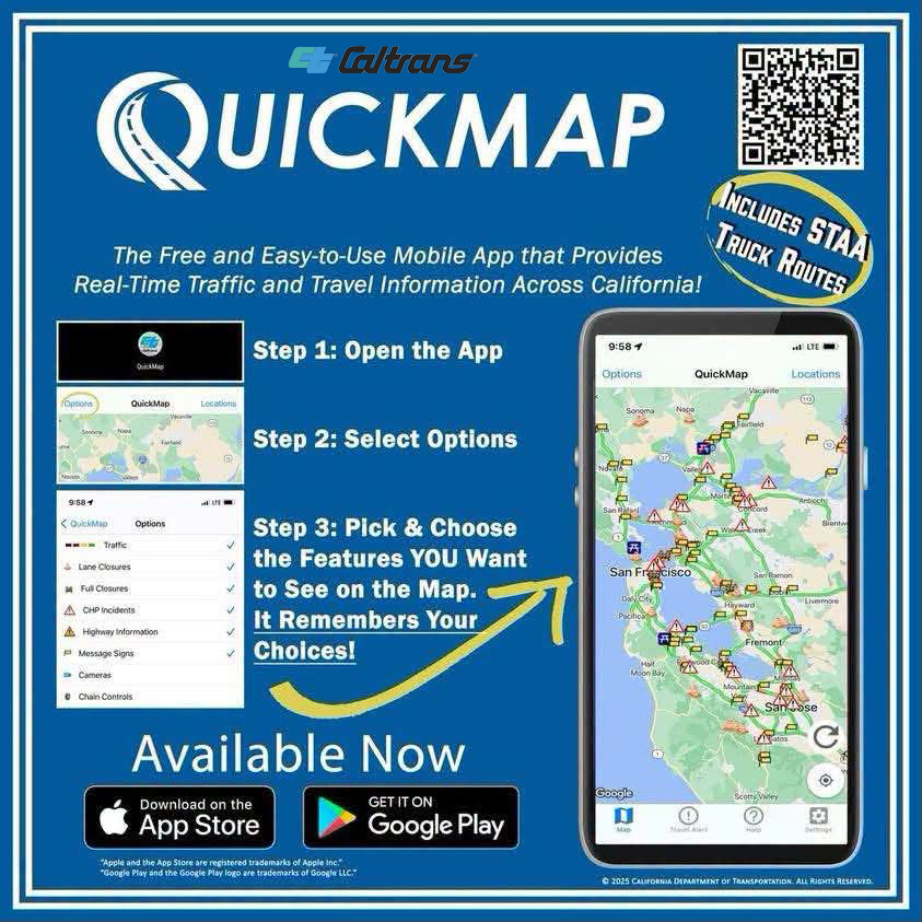
For real-time traffic, click on Caltrans QuickMap: https://bit.ly/3SS8A49

Follow us on X: https://x.com/CaltransD4

Or call 1-800-472-7623, 1-800-427-ROAD for state highway conditions statewide.

About Alfred “Al” Zampa

Photo: Caltrans

According to Caltrans, Alfred “Al” Zampa was the first-born son of Emilio and Maria Zampa, Italian immigrants who migrated to the USA from Abruzzi, Italy. Al was born on March 12, 1905 in Selby, California just down the river from where the bridge that bares his name sits. He was the eldest of three brothers and two sisters.

Al started his career in ironwork when he was 20 years old on the first Carquinez Bridge opening in 1927. He worked on all of the highway and railroad bridges in the area, including the San Francisco – Oakland Bay Bridge and the Golden Gate Bridge. In 1936 Al fell from the Golden Gate into a safety net designed by famous bridge engineer Joseph Strauss. He survived the fall but it severely injured him. After recovering Al immediately returned to his job on the bridge and along with other fall survivors, he helped form the Halfway to Hell Club. The highlight of Al’s career came when his two sons joined him as ironworkers to help build the second Carquinez Bridge that would open in 1958 to carry traffic Eastbound on the new Interstate 80 highway.

In 1987, some years after his retirement, on the 50th anniversary of the completion of the Golden Gate Bridge a play called “The Ace” was produced based on Al’s life story. The play ran at Ft. Point in San Francisco for several weeks. Al began to share his story with the media and was interviewed by magazines, radio shows and TV programs such as “On the Road with Charles Kuralt.” Later Al contributed to the documentary “Skywalkers, A Story of the Ironworkers.”

Al always spoke highly of being a union ironworker and the benefits he received as a union member. He was very competitive and did not like to fail. He enjoyed playing pool and coaching little league baseball. He started the first Tri-City Little League with friends in 1947. He coached his Crockett team to victory, winning the league 6 consecutive years. While working, coaching little league baseball, playing pool, or any of his pastimes, Al Zampa was dedicated to achievement.

In March of 2000 ground was broken on a new suspension bridge to replace the original Carquinez Bridge. Al was there to see history repeat itself. This new bridge is named in memory of Crockett’s own Alfred Zampa, an in recognition of the men and women of the building and construction trades who build these great monuments.

See video of Al Zampa and the opening of the new bridge.


Filed Under: Construction, News, State of California, Transportation

Caltrans: East County Hwy 4 overnight paving and roadway work continues Wednesday night

August 19, 2026 By Publisher Leave a Comment

Source: Caltrans

Paving project tentatively scheduled to be completed by Summer 2027.

By DeNise Harding, PIO, Contra Costa County, Caltrans

Contra Costa County Caltrans crews continue making progress on State Route 4 tonight, Wednesday, August 19 through Thursday with paving, drainage, electrical and guardrail work scheduled throughout the corridor.

For the safety of the motoring public and our crews, Caltrans Construction has adjusted its schedule to allow crews to continue various operations along State Route 4 (SR-4). Overnight full closures, including lane and ramp closures, on westbound and eastbound SR-4 between SR-160 and Byron Highway will continue tonight and Sunday through Thursday nights, between the hours of 7:00 p.m. and 8:00 a.m., as construction progresses. Motorists are advised to plan ahead, allow additional travel time, prepare to merge, and slow for the cone zone. All work is weather dependent and subject to change. For current Caltrans District 4 lane closure information click here.

Full Closure SR-4 — Balfour Road to Byron Highway through 7:00 p.m. to 5:00 a.m.

  • Full closures of the conventional highway sections of SR-4 between Balfour Road and Byron Highway through Marsh Creek Road – for paving operations
  • Full Closures will continue through August 2026 throughout this corridor

Eastbound SR-4 — Hillcrest Avenue to SR-160 8:00 p.m. to 8:00 a.m.

  • Alternating closures of lanes #3 and #4
  • Hillcrest Avenue on-ramp to eastbound SR-4 — CLOSED for drainage improvements

Westbound SR-4 Ramp Closures 7:00 p.m. to 5:00 a.m.

  • Sand Creek Road on-ramp to westbound SR-4 — CLOSED for guardrail work
  • Balfour Road on-ramp to westbound SR-4 — CLOSED for guardrail work
  • Balfour Road off-ramp from westbound SR-4 — CLOSED for electrical work

Eastbound SR-4 Balfour Road Off-Ramp 8:00 p.m. to 8:00 a.m.

  • Balfour Road off-ramp from eastbound SR-4 — CLOSED for electrical work

Please note complete closures, as well as lane and ramp closures, will continue along SR-4 Sunday through Thursday nights as construction progresses. The westbound SR-4 closures are expected to reopen by 5:00 a.m., while the eastbound SR-4 to closures are expected to reopen by 8:00 a.m.

Traveling through the SR-4 corridor tonight? Plan ahead and expect delays. Please follow posted detours, allow extra travel time and slow down when approaching crews and equipment. Your attention behind the wheel helps everyone working along the highway get home safely.

Check QuickMap.dot.ca.gov before you head out.

State Route 4 Detour Information for Full Closure

  • Eastbound SR-4 from Antioch, Pittsburg, and Martinez towards Discovery and Stockton: The detour begins at Balfour Road. Take the Balfour Road exit, turn left on Balfour Road, turn right onto Brentwood Boulevard or continue Balfour Road, then turn right into Byron, follow SR-4.
  • Westbound SR-4 from Discovery Bay and Stockton towards Martinez / Antioch/Oakland: The detour begins at the Byron, turn left onto Brentwood Boulevard, turn left into Balfour Road or continue Byron Highway, turn left into Balfour Road, continue Balfour Road, turn right onto the westbound SR-4 on-ramp, and continue on SR-4.
  • Westbound Vasco Road towards Martinez/Antioch/Oakland: The detour begins at Walnut Boulevard. Turn right on to Walnut Boulevard, turn left onto Balfour Road, continue Balfour Road, turn right onto the west-bound SR-4 on-ramp, and continue to SR-4.
  • Eastbound from Martinez/ Antioch Oakland to Livermore: The detour begins at Balfour exit. Left on Balfour Road, continue Balfour Road, take left turn into Walnut Boulevard, turn left Vasco Road, continue Vasco Road.

All work is weather dependent and subject to change.

This paving project is tentatively scheduled to be completed by Summer 2027.

Drivers may experience minor delays and are advised to plan ahead and allow extra time. For 24/7 traffic updates, follow 511.org on Twitter. For real-time traffic, visit Caltrans QuickMap at Quickmap.dot.ca.gov. To view more D4 Projects, visit: Caltrans D4 Traffic Advisory Publications.

Caltrans thanks the public for their patience and cooperation during these necessary closures and improvements. Your understanding helps keep our crew members and roadways safe for everyone.


Filed Under: Construction, East County, News, State of California, Transportation

Coalition opposing November Bay Area transit tax files lawsuit claiming bias in ballot language, impartial analysis

August 18, 2026 By Publisher 3 Comments

Left graphic source: CABAT

Says “the District Board wrote the RTM Ballot Question…in a way that is intentionally confusing or misleading to voters.”

By Allen D. Payton

The Committee for Affordable Bay Area Transit (CABAT) organized to oppose the Regional Transit Measure (RTM) on the November ballot filed a lawsuit, Monday, against Election Officials in the five included counties and Kimberly Ward, the Public Transit Revenue Measure District Elections Official. If approved by voters, the tax measure, known as Connect Bay Area Transit, will raise a half-cent in four of the five counties, including Contra Costa, Alameda, Santa Clara and San Mateo and one-cent in San Francisco County for 14 years and raise an estimated $17 billion.

Labeled a VERIFIED PETITION FOR WRIT OF MANDATE AND PRELIMINARY INJUNCTION, the lawsuit was filed in Santa Clara County Superior Court by 10 petitioners including former State Senator Quentin L. Kopp, Gregg A. Diéguez, President of CABAT and Director of Sustainability for SHIFT Bay Area, and Marc Joffe, President of the Contra Costa Taxpayers Association, as well as Brian Holtz, Thomas Rubin and five others listed as individuals and electors in the Public Transit Revenue Measure District.

Kopp is also President of the San Francisco Taxpayers Association; Holtz is President of the Purissima Hills Water District Board of Directors in Santa Clara County and Secretary and Treasurer of the Libertarian Party of Santa Clara County; and Rubin is Vice President of the Alameda County Taxpayers Association, Inc.

Attorney Jason Bezis of Lafayette is representing them.

The District was formed to oversee the process for the transit tax measure. (See related article) According to the Fact Sheet for SB 63: Connect Bay Area Act, a separate oversight committee will be formed “to confirm money distribution follows the SB 63 expenditure plan” should the measure pass.

The lawsuit was filed before “the final printing deadline date” of “Friday, August 28, 2026, by which all ballot language and County Voter Information Guides (CVIG) materials must be finalized, including resolving any legal challenges in court.”

Transit Officials Were Warned But Did It Anyway

According to Joffe, “Transit officials cannot claim they were blindsided. On the night of July 23, 2026, the eve of the board’s special meeting, attorney Bezis sent a detailed pre-litigation demand letter urging the board not to approve the question as drafted.  The letter was acknowledged multiple times and the measure was placed on the ballot with the slanted wording anyway.”

Lawsuit cover page. Source: CABAT

Legal Claims

The lawsuit “challenges biased, not neutral, untrue, partial, argumentative, and/or prejudicial wording in the RTM Ballot Question (also called ‘ballot label’ or ‘statement of the measure’) in violation of the Elections Code sections 9051(e) and 13119(c) standards and false and/or misleading wording in the RTM Ballot Question under the Elections Code section 9380/McDonough v. Superior Court (2012) 204 Cal.App.4th 1169 (‘McDonough’) standard. This lawsuit also challenges the Impartial Analysis authored by real party in interest DISTRICT Counsel KATHLEEN KANE as false, misleading, and/or not impartial in violation of Elections Code section 9380.”

The petitioners “seek a writ of mandate to compel amendment of the ballot question (also known as ‘ballot label’ or ‘statement of the measure’) and the impartial analysis that Respondents COUNTY ELECTIONS OFFICIALS and Ms. WARD are preparing for voter use in the Regional Transit Measure (‘RTM’) election to be held on November 3, 2026.”

Further, the lawsuit claims, “Petitioners assert that the DISTRICT and DISTRICT BOARD wrote the RTM Ballot Question…in a way that is intentionally confusing or misleading to voters.”

Current Ballot Language

The lawsuit explains, “As approved by the PTRMD BOARD at its July 24, 2026 meeting, the RTM Ballot Question (see District Resolution No. 2 Page 7) currently reads:

‘To prevent major service cuts to BART and other transit, avoid increased traffic, and reduce pollution by: Preserving BART, Caltrain, VTA, SamTrans, AC Transit, Muni, other transit for everyone, including workers, students, seniors, persons with disabilities; Supporting transit safety, cleanliness, affordability, reliability; Repairing targeted roads/potholes; Requiring financial transparency, oversight, accountability; shall the measure enacting a 0.5% (Alameda, Contra Costa, San Mateo, Santa Clara counties), and 1% (San Francisco) sales tax for 14 years generating approximately $980,000,000 annually, be adopted?’”

Challenges & Proposed Changes

However, the petitioners claim the adopted ballot language does not comply with state Elections Code and the amount is incorrect and should instead be $1.2 million per year. They claim the statement of the measure is not “a true and impartial synopsis of the purpose of the proposed measure,” is “argumentative” and “likely to create prejudice for or against the measure,” and that the “RTM Ballot question is inherently prejudicial” based on a survey MTC conducted last year. Furthermore, the petitioners “argue that components of the RTM Ballot Question are false and/or misleading.”

They want to make the following changes:

  • Amend the phrase “Preserving BART …” to read “Funding BART …”
  • Delete the phrase “for everyone, including workers, students, seniors, persons with disabilities”.
  • Delete the phrase “To prevent major service cuts to BART and other transit”.
  • Alternatively, strike the word “major” in the phrase “To prevent major service cuts …”
  • Delete the phrase “avoid increased traffic”.
  • Delete the phrase “reduce pollution”.
  • Strike the phrase “/potholes”.
  • Amend “Repairing targeted roads” to read “Repaving transit-served roads”.
  • Strike the words “affordability, reliability”.
  • Amend “enacting” to read “imposing”.
  • Amend the phrase “sales tax” to read “sales and use tax”.
  • Strike the word “oversight” in the phrase “Requiring … oversight”.
  • Strike the word “accountability” in the phrase “Requiring … accountability”.
  • Amend “$980,000,000 annually” (September 2025 estimate) to an updated number (an August 2026 estimate) or “$1,200,000,000 annually” (September 2025 estimates, averaged over 14 years).

Alternative Ballot Language

The lawsuit offers the following ballot language alternatives:

“If the Court were to order all of the amendments and corrections suggested by Petitioners supra, the RTM Ballot Question would read:

‘Funding BART, Caltrain, VTA, SamTrans, AC Transit, Muni, other transit; Supporting transit safety, cleanliness; Repaving transit-serving roads; Requiring financial transparency; shall the measure imposing a 0.5% (Alameda, Contra Costa, San Mateo, Santa Clara counties) and 1% (San Francisco) sales and use tax for 14 years generating approximately $1,200,000,000 annually, be adopted?’”

The lawsuit further reads, “If the Court were to order all of the amendments and corrections suggested by Petitioners supra, including use of the ‘Shall the measure … be adopted?’ format, the RTM Ballot Question would read:

‘Shall the measure imposing a 0.5% (Alameda, Contra Costa, San Mateo, Santa Clara counties) and 1% (San Francisco) sales and use tax for 14 years generating approximately $1,200,000,000 annually; Funding BART, Caltrain, VTA, SamTrans, AC Transit, Muni, other transit; Supporting transit safety, cleanliness; Repaving transit-serving roads; Requiring financial transparency; be adopted?’”

The petitioners also claim the “RTM Impartial Analysis is partial, false, and/or misleading” and that it should be written by either the California Attorney General, a county counsel or district attorney instead of Kathleen Kane who is he legal counsel for the District.

“Supporters of the Transit Measure need to use misleading advertising because voters won’t pass the measure if they have the real story that it is a regressive tax falling hardest on seniors and low-income families for 14 years,” Dieguez stated.

“Voters deserve the honest description the law guarantees them, and if the district won’t provide it, a court should,” Joffe added.

See the Public Transit Revenue Measure District’s Legal Counsel RTM Impartial Analysis.

See RTM Ballot Question Lawsuit Aug 17

For more information about CABAT visit Committee for Affordable Bay Area Transit.

The election is Tuesday, Nov. 3.

Filed Under: Bay Area, Legal, News, Politics & Elections, Taxes, Transportation

Public Transit Revenue Measure District formed, governed by MTC Board

August 18, 2026 By Publisher 1 Comment

Photo, agency & map graphics: MTC

To oversee process for Bay Area transit tax on Nov. ballot

By Metropolitan Transportation Commission

OAKLAND, CA – Updated Aug. 17, 2026 – The Public Transit Revenue Measure District (PTRMD) was established under Government Code Title 7.85, by Senate Bill 63 (2025), which also authorizes a regional transportation revenue measure to be placed on the November 2026 ballot, known as the Connect Bay Area Transit Initiative.

District Members

The Public Transit Revenue Measure District is comprised of the same individuals that govern the Metropolitan Transportation Commission (MTC).

The PTRMD on Jan. 16, 2026, received a notice of intent from the Connect Bay Area Transit Committee to place a citizen’s initiative on the November 2026 ballot. Senate Bill 63, authored by state senators Scott Wiener of San Francisco and Jesse Arreguín of Berkeley, authorized a qualified voter initiative to impose a retail transactions and use tax ordinance applicable to the entire district for a duration of 14 years, in an amount of 0.5% in each of the counties located within the district and 1% in the City and County of San Francisco, subject to voter approval at the November 3, 2026, statewide general election.

On July 1, 2026, the District Elections Official issued a Certificate to Initiative Petition, certifying that proponents of the Connect Bay Area Transit Initiative submitted sufficient valid signatures for the measure to qualify for placement on the ballot.

The District at its July 24, 2026, meeting formally approved a resolution accepting the District Elections Official’s certification of the Connect Bay Area Transit initiative measure and requesting the Boards of Supervisors in Alameda, Contra Costa, San Francisco, San Mateo and Santa Clara counties to call a special election on the measure and to consolidate this special election with the November 3, 2026, statewide general election.

Impartial Analysis of Regional Transit Measure 

Legal counsel for the Public Transit Revenue Measure District has prepared an impartial analysis of the  Regional Transit Measure pursuant to subdivision (d) of Government Code 67740. This text will also be included in each county’s voter information guide per state law.

Notices of Election Provided by Santa Clara County

Santa Clara County Registrar of Voters provided the following notices of election:

  • Notice of General Election
  • 大選通告
  • AVISO DE ELECCIÓN GENERAL
  • THÔNG BÁO TỔNG TUYỂN CỬ
  • Paunawa Sa Pangkalahatang Halalan

Election-Related Deadlines 

Established election dates related to the measure can be found on the Santa Clara County Registrar of Voters (ROV) website. Please reference the most recently published Public Transit Revenue Measure District (PTRMD) calendars, which may be accessed at the SantaClaraCounty.gov website.  If you are unable to access the link, please contact the Santa Clara County ROV directly for assistance.

Staff Contact

Kimberly Ward, District Elections Official
Phone: 415-778-5367
Email: kward@bayareametro.gov

請求協助! | ¡Solicita ayuda! | Request assistance! 

您是否需要我們翻譯其中一份文件的內容? 您是否需要大字體或盲文印刷的書面資料? 您是否需要手語或您所說語言的口譯服務才能參與?

如需協助,請致電 (415) 778-6757。若需使用 TDD 或為聽障人士,請致電 711,加州轉接服務,或 (800) 735-2929 (TTY) ,(800) 735-2922 (語音),然後要求轉接至(415) 778-6700。請至少提前三個工作日提出申請,以便我們能為您提供適當的安排。

¿Necesita que alguno de nuestros documentos sea traducido? ¿Necesita nuestras comunicaciones escritas en letra grande o en Braille? ¿Necesita un intérprete del lenguaje de señas o un intérprete que hable su idioma para poder participar?

Para solicitar asistencia, por favor llamemos al (415) 778-6757. Para telecomunicaciones para personas sordas y discapacitadas, favor de llamar al 711, el Servicio de Retransmisión de California (CRS) para TTY/VCO/HCO a Voz o para Voz a TTY/VCO/HCO al (800) 855-3000 y pedir que lo conecten al (415) 778-6700. Necesitamos aviso de al menos tres días hábiles de anticipación para proporcionar la asistencia adecuada.

Do you need one of our documents translated? Do you need written materials in large type or in Braille? Do you need a sign language interpreter or an interpreter who speaks your language in order to participate?

To request accommodation, please call (415) 778-6757. For TDD or hearing impaired, call 711, California Relay Service, or (800) 735-2929 (TTY), (800) 735-2922 (voice) and ask to be relayed to (415) 778-6700. We require at least three working days’ notice to accommodate requests.

For more information visit Public Transit Revenue Measure District.

Allen D. Payton contributed to this report.
 

Filed Under: Bay Area, Government, News, Politics & Elections, Taxes, Transportation

  • 1
  • 2
  • 3
  • …
  • 34
  • Next Page »
RepublicServices-Antioch-ad (1)
Monica's Riverview 09-26 A (1)
Celia's-09-26B
Delta-RC-B 07-26
Deer-Valley-Chiro-06-22

Copyright © 2026 · · Contra Costa Herald · All Rights Reserved