






¡Acompáñanos en nuestro primer Paseo de Halloween en el centro de Richmond!
By Richmond Main Street Initiative
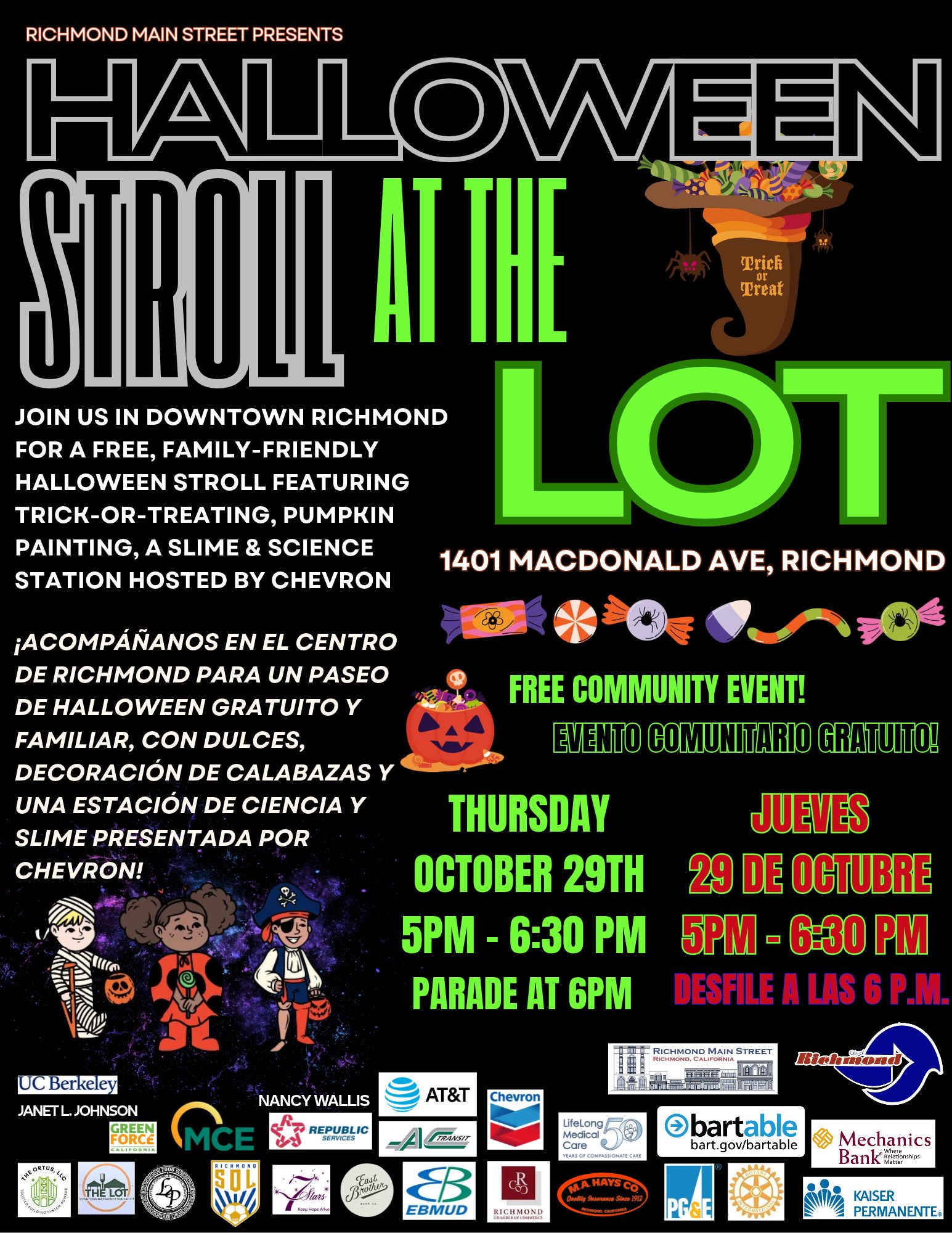
Join us for our first Halloween Stroll in Downtown Richmond!
Take a stroll around The LOT, show off your Halloween costumes, and join us for a Halloween parade starting at 6 PM!
This free, family-friendly event will include:
- Halloween Parade starting at 6 PM
- Slime & Science Station hosted by Chevron, where kids can make monster goo
- Mini pumpkin painting while supplies last
- Trick-or-treating at The LOT and participating local businesses
Bring the family and enjoy Halloween in Downtown Richmond! We hope to see you there!
- Thursday October 29th
- 5 pm to 6:30 pm
- 1401 Macdonald Ave., Richmond, CA.94801 (The LOT)
___________________
¡Acompáñanos en nuestro primer Paseo de Halloween en el centro de Richmond!
Recorre The LOT, luce tu disfraz de Halloween y únete a nuestro desfile de Halloween que comienza a las 6 PM.
Este evento gratuito y familiar incluirá:
- Desfile de Halloween a partir de las 6 PM
- Estación de Ciencia y Slime, presentada por Chevron, donde los niños podrán crear su propio slime monstruoso
- Decoración de mini calabazas, hasta agotar existencias
- Truco o trato en The LOT y en los negocios participantes del centro de Richmond
¡Ven con tu familia y disfruta de Halloween en el centro de Richmond! ¡Esperamos verte allí!
- Jueves 29 de Octubre
- 5 pm to 6:30 pm
- 1401 Macdonald Ave., Richmond, CA.94801 (The LOT)
Presented by the Richmond Main Street Initiative.
The Richmond Main Street Initiative, Inc. is a community-based nonprofit corporation dedicated to revitalizing historic Downtown Richmond as a pedestrian-friendly urban village, offering products, services, arts, and entertainment that reflect the community’s rich and diverse heritage.
For more information visit www.richmondmainstreet.com.
Allen D. Payton contributed to this report.
Read More
Five local bands unite to promote community and civic engagement bringing live music, costumes, community organizations and nonpartisan voter engagement together ahead of the November election.
By Mike Rodriguez, Founder & President, Rage for Democracy
BRENTWOOD, CA — Five local bands will take the stage at the Brentwood Community Center on Friday, October 30, for Night of the Living Loud, an all-ages Halloween rock concert organized by Brentwood-based nonprofit Rage for Democracy.
Sponsored by the City of Brentwood, the event combines live music, a Halloween costume contest, local vendors, community organizations, and nonpartisan civic engagement just days before the November general election.
The lineup features DownbyDown, Dumpster Pyre, Jimmy Party, The Slums, and WheelHouse, bringing together musicians from the local rock and alternative music scene for an evening centered on music, creativity, and community involvement.
Local Musicians Speak Out on Civic Participation
In preparation for the concert, members of the participating bands recently gathered for a meetup, sharing pizza, taking promotional photos, and discussing why voting and community involvement matter to them.
Jouz, singer and guitarist for DownbyDown, emphasized the importance of neighbors supporting one another.
“It’s important to be involved in your community because you want people to look out for you the same way that you would want to look out for them, and vice versa.”
Thomas, guitarist for Dumpster Pyre, spoke about the direct impact voting can have.
“Biggest reason to come out and vote is to have a direct impact on your community and help shape where you are.”
Sebastian, vocalist and guitarist for Jimmy Party, echoed that message.
“Voting is important to get an overall representation of how people feel and getting your voices heard.”
Tyrese, bassist for Dumpster Pyre, offered a straightforward message about participation.
“Think about it this way. Just make a vote. It makes a big change, and that’s all you really need.”
These perspectives reflect the event’s larger goal: helping people recognize that being involved in their communities doesn’t have to begin in a government building or at a political event. Sometimes, it can start with a conversation at a rock show.
Music, Community, and Voter Engagement
Beyond the performances, Night of the Living Loud will feature a Halloween costume contest, band merchandise, local vendors, and tables hosted by community organizations.
Rage for Democracy is also working in partnership with HeadCount, a national nonpartisan nonprofit that promotes voter registration and civic participation through music and live events.
The collaboration reflects a shared belief that music can provide a meaningful connection between young people, their communities, and the democratic process.
The concert is nonpartisan and is not intended to promote any political party or candidate. Instead, the focus is on encouraging individuals to become informed, participate, and recognize the power of their own voices.
The organization is still accepting inquiries from local vendors and businesses interested in participating, providing an opportunity for small businesses, creators, and community groups to connect with concertgoers.
Those interested in vendor spaces, sponsorship opportunities, or community organization participation can contact mike@ragefordemocracy.com for more information.
Building Community Through Music
Rage for Democracy is a Brentwood-based 501(c)(3) nonprofit organization that uses music, civic education, and community service to bring people together.
Its programs include Citizens Civics Club, a free community civics education program; Rage Clean, a volunteer neighborhood cleanup initiative; and the Instrument Closet, a program that makes musical instruments more accessible to the community.
Night of the Living Loud expands on that mission by bringing local musicians, community organizations, businesses, and residents together under one roof.
With the City of Brentwood sponsoring the event’s venue costs, the organization hopes to create an accessible concert experience while supporting the local music scene and introducing attendees to opportunities to get involved in their community.
EVENT INFORMATION
Night of the Living Loud
Friday, October 30, 2026 | 6:00 PM
Brentwood Community Center – 35 Oak Street
Featuring: DownbyDown, Dumpster Pyre, Jimmy Party, The Slums, and WheelHouse
Tickets: $15 in advance | $20 at the door
Admission: All ages
Sponsored by: City of Brentwood
Tickets and additional event information are available at https://www.ragefordemocracy.com.
For vendor inquiries, sponsorship opportunities, or additional information, email mike@ragefordemocracy.com.
About Rage for Democracy
Rage for Democracy is a Brentwood-based 501(c)(3) nonprofit organization dedicated to strengthening communities through nonpartisan civic education, volunteer service, music and creative expression. Guided by the belief that everyone deserves a place to gather, create, connect, and belong, the organization works to make civic and community participation accessible to everyone. www.ragefordemocracy.com.
Read More
Source: Educational Results Partnership
By Marcus Walton, Director, Communications and Special Projects, Contra Costa County Office of Education
PLEASANT HILL, Calif.— Forty-six schools and six school districts in Contra Costa County have been named to the 2026 California Honor Roll, a recognition presented by Educational Results Partnership (ERP) and the Campaign for Business and Education Excellence.
The recognition highlights schools and districts that are demonstrating strong student achievement, making measurable progress in closing achievement gaps among historically underserved student groups, and improving outcomes for all students. Among the 2,080 schools and 168 districts recognized statewide, Contra Costa County schools and districts continue to stand out for their commitment to student success.
“It is meaningful to see the business community recognize the outstanding work taking place in our schools and districts,” Contra Costa County Superintendent of Schools Lynn Mackey said. “This distinction highlights how public education in Contra Costa County is preparing students to be future ready with the knowledge, skills, and opportunities they need to thrive in college, careers and their communities.”
The six Contra Costa County school districts named to the 2026 California Honor Roll are: Acalanes Union High School District, Brentwood Union School District, Lafayette Elementary School District, Moraga Elementary School District, Orinda Union School District, and San Ramon Valley Unified School District.
The following 46 schools in the county were also honored:
- Campolindo High School — Acalanes Union High School District
- Miramonte High School — Acalanes Union High School District
- Adams (J. Douglas) Middle School — Brentwood Union School District
- Edna Hill Middle School — Brentwood Union School District
- Garin Elementary School — Brentwood Union School District
- Isaac R. Montañez Elementary School — Brentwood Union School District
- R. Paul Krey Elementary School — Brentwood Union School District
- Ron Nunn Elementary School — Brentwood Union School District
- Discovery Bay Elementary School — Byron Union Elementary School District
- Burton Valley Elementary School — Lafayette Elementary School District
- Happy Valley Elementary School — Lafayette Elementary School District
- Lafayette Elementary School — Lafayette Elementary School District
- M. H. Stanley Middle School — Lafayette Elementary School District
- Springhill Elementary School — Lafayette Elementary School District
- Heritage High School — Liberty Union High School District
- Martinez Junior High School — Martinez Unified School District
- Donald L. Rheem Elementary School — Moraga Elementary School District
- Joaquin Moraga Intermediate School — Moraga Elementary School District
- College Park High School — Mt. Diablo Unified School District
- Hidden Valley Elementary School — Mt. Diablo Unified School District
- Monte Gardens Elementary School — Mt. Diablo Unified School District
- Pleasant Hill Middle School — Mt. Diablo Unified School District
- Rocketship Futuro Academy — Rocketship Public Schools
- Sequoia Middle School — Mt. Diablo Unified School District
- Walnut Acres Elementary School — Mt. Diablo Unified School District
- Del Rey Elementary School — Orinda Union School District
- Glorietta Elementary School — Orinda Union School District
- Orinda Intermediate School — Orinda Union School District
- Sleepy Hollow Elementary School — Orinda Union School District
- Wagner Ranch Elementary School — Orinda Union School District
- Alamo Elementary School — San Ramon Valley Unified School District
- Bollinger Canyon Elementary School — San Ramon Valley Unified School District
- Coyote Creek Elementary School — San Ramon Valley Unified School District
- Creekside Elementary School — San Ramon Valley Unified School District
- Diablo Vista Middle School — San Ramon Valley Unified School District
- Golden View Elementary School — San Ramon Valley Unified School District
- Hidden Hills Elementary School — San Ramon Valley Unified School District
- John Baldwin Elementary School — San Ramon Valley Unified School District
- Pine Valley Middle School — San Ramon Valley Unified School District
- Rancho Romero Elementary School — San Ramon Valley Unified School District
- Sycamore Valley Elementary School — San Ramon Valley Unified School District
- Tassajara Hills Elementary School — San Ramon Valley Unified School District
- Tice Creek School — Walnut Creek School District
- Middle College High School — West Contra Costa Unified School District
- Richmond College Preparatory School — West Contra Costa Unified School District
- West County Mandarin School — West Contra Costa Unified School District
Now in its 12th year, the California Honor Roll uses California Assessment of Student Performance and Progress (CAASPP) results from 2024-26 to recognize schools and districts that are driving academic growth and improving student outcomes. The honor highlights educational communities that help students build the foundational skills needed for college, career, and life.
According to ERP, the Honor Roll identifies schools that are helping students build the foundational skills needed for college, career and life. ERP partners with business leaders and chambers of commerce throughout California to recognize schools and districts making measurable progress in student achievement. The Honor Roll is the only school recognition program presented in partnership with business leaders and based solely on student achievement outcomes.
To view the full list of California Honor Roll schools and districts, visit www.honorrollschools.com.
About Educational Results Partnership
Educational Results Partnership (ERP) is a nonprofit organization that applies data science and predictive analytics to identify successful public education systems, practices, programs, and policies that deliver the best results for students. ERP has accumulated the nation’s largest database on student achievement from kindergarten into the labor market. In partnership with educators and employers, ERP charts the pathways that lead to academic success and living-wage jobs. ERP’s goal is to ensure that more students are equipped to enter the workforce with the skills today’s global economy demands. For more information visit: edresults.org.
About Campaign for Business and Education Excellence
The Campaign for Business and Education Excellence (CBEE) aims to improve economic mobility for the next generation of learners by matching talent to jobs and career opportunities. Aligning academic achievements with job market needs, the campaign engages employers while helping learners pursue careers matched to their existing skills and abilities. Learners across the United States can discover how their education opens doors to immediate career opportunities. For more information visit: edcampaign.org.
About Contra Costa County Office of Education
One of 58 counties in California, Contra Costa County has the 11th largest public-school student population in the state (approximately 169,225 students). Officially established in 1932, CCCOE has a long history of providing direct services to some of the county’s most vulnerable students, including young people who are incarcerated, homeless, or in foster care, as well as students who have severe physical or emotional challenges.
CCCOE also provides support services to schools and school districts in Contra Costa County; services that can be handled most effectively and economically on a regional basis rather than by each of the county’s 286 schools or 18 school districts. These services range from budget approval and fiscal support to technology infrastructure, communication support, and high-level professional development opportunities for educators. CCCOE maintains a website at www.cocoschools.org.
Read More
To prohibit election intimidation in compliance with state laws in response to concerns Pres. Trump is trying to influence results
By Dawn Kruger Community and Media Relations Coordinator Contra Costa County Clerk-Recorder-Elections Department
Martinez, California – As voting gets underway for the November 3rd General Election, Contra Costa County’s Clerk-Recorder and Registrar of Voters, District Attorney and Sheriff are standing together to ensure every voter can cast a ballot safely and with confidence.
California has long led the nation in protecting the right to vote, and its election safeguards keep getting stronger. The Peace Act (AB 2642), signed into law in September 2024, established clear protections for voters and election workers in all 58 counties by explicitly prohibiting intimidation and threats at the polls. It treats the presence of a firearm, or even a replica of one, at a polling place as unlawful intimidation, and it gives voters, election officials, and election workers the right to take civil legal action against anyone who tries to intimidate or coerce them.
Legislation signed by Governor Gavin Newsom this September builds on that foundation. The new laws make it a felony to tamper with ballots, election records, or voting equipment, guard voters against deepfakes and deception, and expand access to the ballot box, giving election and law enforcement officials across the state more tools to keep elections safe, secure, and fair. For Contra Costa County voters, that means every ballot, whether cast at a polling place, dropped in a drop box, or returned by mail, is protected from the moment it’s cast until the final count.
In his signing statement Newsom said, “Donald Trump won’t stop until he can exert dictatorial control over your free vote and disenfranchise millions of people this November. California will stop him at every opportunity. We have no bigger task than fighting to protect the right to vote from interference and meddling – the future of democracy is on the line. These bills today build upon the wall California has built to safeguard our electoral process.”
Contra Costa voters can vote their way with confidence, say the three County officials.
“As the Chief Elections Officer for Contra Costa County, I want to encourage all eligible Contra Costa residents to vote and to know that we expect another safe and secure election,” said Kristin B. Connelly, Clerk-Recorder and Registrar of Voters. “I also want to reassure voters that we take extensive safety precautions in every election. We partner closely with local law enforcement to ensure that all Contra Costa Voters can feel confident voting with their preferred method either by drop box, through the post office, or in-person.”
Contra Costa District Attorney Diana Becton said, “Your vote is your voice, and we will protect it. From the mailbox to the drop box to the polling place, my office and our law enforcement partners are making sure every eligible voter in Contra Costa County can cast a ballot freely, safely, and with confidence that their voice will be heard.”
“As the election approaches, the Contra Costa Sheriff’s Office is working with its law enforcement partners to ensure this election is safe and that we will help protect residents’ right to vote,” said Sheriff David Livingston.
However, the Contra Costa County Elections Division still uses the controversial Dominion voting equipment purchased in 2018 that has removal flash drives, as well as Scytle software. (See related articles here, here and here)
Since then, Dominion Voting Systems, a Canadian company, was purchased in 2025 by election reform advocate Scott Leiendecker under a new company called Liberty Vote based in Denver, Colorado.
For more information on how or where to vote, visit the Contra Costa County Elections website www.contracostavote.gov.
Allen D. Payton contributed to this report.
Read More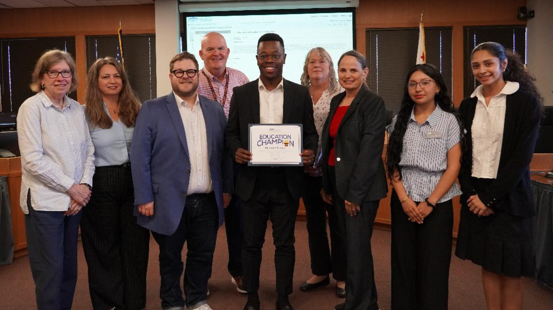
Richmond Promise Executive Director Christopher Whitmore (center) with Contra Costa County Superintendent of Schools Lynn Mackey (right) and members of the Contra Costa County Board of Education, (L-R) President Sarah Butler, Daniel Nathan-Heiss, Vice President Yazmin Llamas, Mike Maxwell, Annette Lewis and student members, Melanie Hernandez-Rios and Valeria Gonzalez-Sandoval. Photo: CCCOE
By Marcus Walton, Director, Communications and Special Projects, Contra Costa County Office of Education
PLEASANT HILL, Calif.— Contra Costa County Superintendent of Schools Lynn Mackey and the County Board of Education recognized Richmond Promise for a decade of helping students in Richmond pursue higher education and career opportunities.
Since its founding in 2016, Richmond Promise has awarded more than $14 million in scholarships to students, according to the organization. Among scholarship recipients, 91% identify as people of color or Indigenous, and 64% are the first in their families to pursue higher education.
“Students in our county need Education Champions like Richmond Promise to make connections and give them a leg up to pursue their dreams,” Contra Costa County Superintendent of Schools Lynn Mackey said. “Programs that provide scholarships and pathways to higher education or job training are the lifelines our kids need, and we need more of them. Thank you to Executive Director Christopher Whitmore, his team, and the Richmond Promise Board of Directors for 10 years of investing in future leaders.”
Richmond Promise is a communitywide college success initiative dedicated to expanding access to higher education for Richmond students and supporting them throughout their academic journeys. Through scholarships, student success programs and partnerships with local organizations, the nonprofit works to build a culture that encourages college enrollment, persistence, and graduation.
The organization’s approach begins with early college awareness and continues through financial literacy, college access, and college completion. Through scholarships, financial aid support, workshops, coaching, career mentorship and peer networks, Richmond Promise helps students navigate the path to higher education and career success.
By connecting students with resources and opportunities, Richmond Promise aims to remove barriers to educational attainment while helping develop future leaders who can contribute to and strengthen their communities.
The Education Champion Award recognizes community partners that demonstrate an exceptional commitment to supporting students, schools and educational programs across Contra Costa County. Honorees help expand opportunities, strengthen community connections, and provide resources that support public education.
About Contra Costa County Office of Education
One of 58 counties in California, Contra Costa County has the 11th largest public-school student population in the state (approximately 169,225 students). Officially established in 1932, CCCOE has a long history of providing direct services to some of the county’s most vulnerable students, including young people who are incarcerated, homeless, or in foster care, as well as students who have severe physical or emotional challenges.
CCCOE also provides support services to schools and school districts in Contra Costa County; services that can be handled most effectively and economically on a regional basis rather than by each of the county’s 286 schools or 18 school districts. These services range from budget approval and fiscal support to technology infrastructure, communication support, and high-level professional development opportunities for educators. CCCOE maintains a website at www.cocoschools.org.
Read More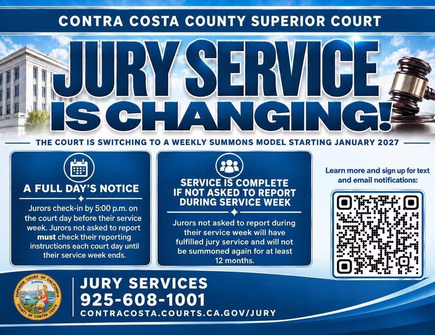
Source: CCC Superior Court
Ends midday call-ins, reduces number of jurors summoned, aligns with most Bay Area courts
By Dan Radovich, ADA and Communications Manager, Contra Costa County Superior Court
MARTINEZ, Calif. – Beginning January 4, 2027, the Contra Costa County Superior Court will transition to a weekly jury summons model. Residents will be summoned for jury service less often under this new model, which is projected to reduce the number of jurors summoned each year by approximately 20%. The change also eliminates midday call-ins. Instead, jurors will know the day before whether they need to report. The first summonses under the weekly model will be mailed beginning November 9, 2026.
The change results, in part, from the Court’s strategic planning process and the feedback residents provided about their experience with jury service in Contra Costa County. The Court reviewed its jury operations and historical data, identifying weekly summonsing as a practical way to make jury service less disruptive. Weekly summonsing also brings the Court in line with most other Bay Area courts, which already summon jurors by the week.
What the Change Means for Jurors
Residents will be summoned for a service week instead of a single day. Under the Court’s new model:
- A full day’s notice. Jurors will check their reporting instructions by 5:00 p.m. beginning the court day before their service week. Jurors who are not asked to report must continue to check their reporting instructions each court day until their service week ends.
- Service is complete if not asked to report during service week. Jurors who are not asked to report during their service week will have fulfilled their jury service and will not be summoned again for at least 12 months.
Service weeks will begin on Monday, or Tuesday when Monday is a court holiday. Under the current system, jurors are often instructed to call in at 11:30 a.m. and then asked to report by 1:00 p.m. that afternoon. The new weekly model eliminates midday call-ins and same-day reporting. However, it does not change what happens when jurors report. Under the statewide “one day or one trial” policy, jurors
who report and are not assigned to a courtroom will complete their jury service that same day. Jurors assigned to a courtroom for jury selection or impaneled on a trial will return as directed by the judge.
Expected Impact
In 2025, the Court mailed over 305,000 jury summonses to support more than 250 criminal, civil, and probate jury trials. Weekly summonsing allows Jury Services to better match the number of jurors asked to report with courtroom needs on a given day. Based on its analysis of 2025 data, the Court projects the model will:
- Reduce the number of annual summonses by approximately 61,000.
- Save approximately $31,000 a year in printing and postage costs.
The Court will evaluate actual results following implementation, including summons volume, failure-to-appear rates, juror utilization, and courthouse operations.
“Jury service is an important civic responsibility, but we also recognize that it can be challenging to fit into work, family, and other obligations,” said Sarah Lind, Court Executive Officer and Jury Commissioner. “This new model is a meaningful step toward making jury service more predictable and manageable for residents, while continuing to meet the needs of our courtrooms.”
Jurors will continue to have the option to receive their reporting instructions by text message or email. Additional information about the Court’s new jury summons model and instructions for signing up for text message and email notifications are available on the Juror Service Center page of the Court’s website: contracosta.courts.ca.gov/jury. Jury Services may be contacted by phone at (925) 608-1001.
Read More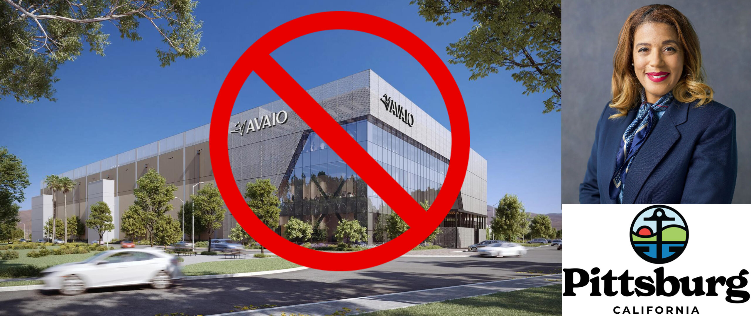
AVAIO Digital data center rendering and Mayor Dionne Adams official photo. Source: City of Pittsburg
PITTSBURG, CA — Mayor Dionne Adams issued the following statement today, Thursday, Oct. 22, 2026:
On Monday, October 26, the Pittsburg City Council will consider a 45-day emergency moratorium on future data center development, including Phases II and III of the AVAIO project. This follows months of residents speaking up, asking questions and sharing concerns about what data centers mean for their families and neighborhoods.
Although my employer’s involvement has required me to recuse myself from recent project-related decisions, my responsibility to listen to residents and help ensure their questions are answered has remained central to my work as Mayor.
For the last few months, I directed the City Manager and staff to expand their outreach across the City, online and in-person, and called for a dedicated Council meeting focused entirely on data centers – where the creation of a community advisory council followed. More recently, I’ve routinely requested formal updates from the City Manager to the public, all of this ultimately leading to the upcoming moratorium vote.
The City’s advisory council is currently developing recommendations for future data center policies, and the Council’s upcoming moratorium vote will enable council to complete that work.
Pittsburg is my home, too. As our understanding of data centers and AI infrastructure evolves, we have a responsibility to keep learning and responding to the people whose lives and neighborhoods are affected. I won’t get every decision right, but I will always listen, take your concerns seriously, and do what I believe is in the best interests of Pittsburg and its residents, even when I cannot vote on every individual item.
To everyone who has taken the time to speak with me, attend a meeting or ask a difficult question: thank you. You deserve a City government that hears you and responds.
Monday’s meeting agenda has not yet been published on the City’s website. Please check the Agendas and Minutes page, later, here: Pittsburg, CA – Agendas & Minutes.
Allen D. Payton contributed to this report.
Read More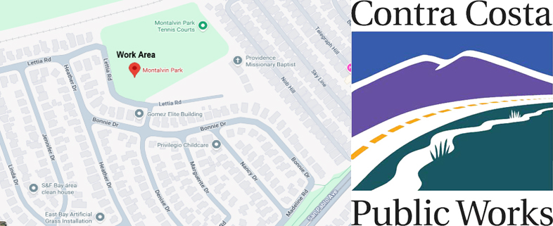
Montalvin Park Playground Work Area Map. Source: CCC Public Works
By Carrie Ricci, Deputy Director, Contra Costa County Public Works Department
Unincorporated Contra Costa County, CA – A contractor for Contra Costa County Public Works will perform maintenance to the rubberized surfacing in one of the play areas at Montalvin Park, located between San Pablo and Hercules in West County, on Wednesday, October 28, 2026, between 8:00 a.m. and 4:00 p.m., barring unforeseen circumstances. The play area will remain closed for the remainder of the week with access restored on Wednesday, November 4, 2026, weather permitting.
The purpose of this work is to apply treatment to the rubberized surface beneath the play area structures. The play area should not be accessed while the fencing is in place. Walking on the surface during the curing process can affect the finished product. Maintaining the integrity of the newly treated surface is essential to ensuring long-term safety for all park users.
Contra Costa County Public Works appreciates the community’s cooperation and understanding as this essential work is performed.
About Contra Costa County Public Works Department
The Contra Costa County Public Works Department (CCCPWD) is responsible for the maintenance and operation of over 650 miles of roads, 79 miles of streams and channels, and over 150 County buildings. CCCPWD services include parks and recreation, sandbag distribution, flood control, road and facilities maintenance, and storm water management. CCCPWD operates two airports, Buchanan Field Airport in Concord and Byron Airport in Byron. For more information about CCCPWD, please visit us at: www.cccpublicworks.org.
Read More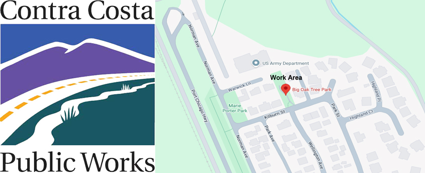
Big Oak Tree Park, Clyde Work Area Map. Source: CCC Public Works
By Carrie Ricci, Deputy Director, Contra Costa County Public Works Department
Clyde, CA – A contractor for Contra Costa County Public Works will perform repairs and maintenance to the rubberized surfacing in the play area at Big Oak Tree Park on Tuesday, October 27, 2026, between 8:00 a.m. and 4:00 p.m., barring unforeseen circumstances. The play area will remain closed for the remainder of the week and will reopen on Tuesday, November 3, 2026, weather permitting.
The purpose of this work is to complete repairs and apply treatment to the rubberized surface beneath the play area structures. The play area should not be accessed while the fencing is in place. Walking on the surface during the curing process can affect the finished product. Maintaining the integrity of the newly treated surface is essential to ensuring long-term safety for all park users.
Contra Costa County Public Works appreciates the community’s cooperation and understanding as this essential work is performed.
About Contra Costa County Public Works Department
The Contra Costa County Public Works Department (CCCPWD) is responsible for the maintenance and operation of over 650 miles of roads, 79 miles of streams and channels, and over 150 County buildings. CCCPWD services include parks and recreation, sandbag distribution, flood control, road and facilities maintenance, and storm water management. CCCPWD operates two airports, Buchanan Field Airport in Concord and Byron Airport in Byron. For more information about CCCPWD, please visit us at: www.cccpublicworks.org.
Read More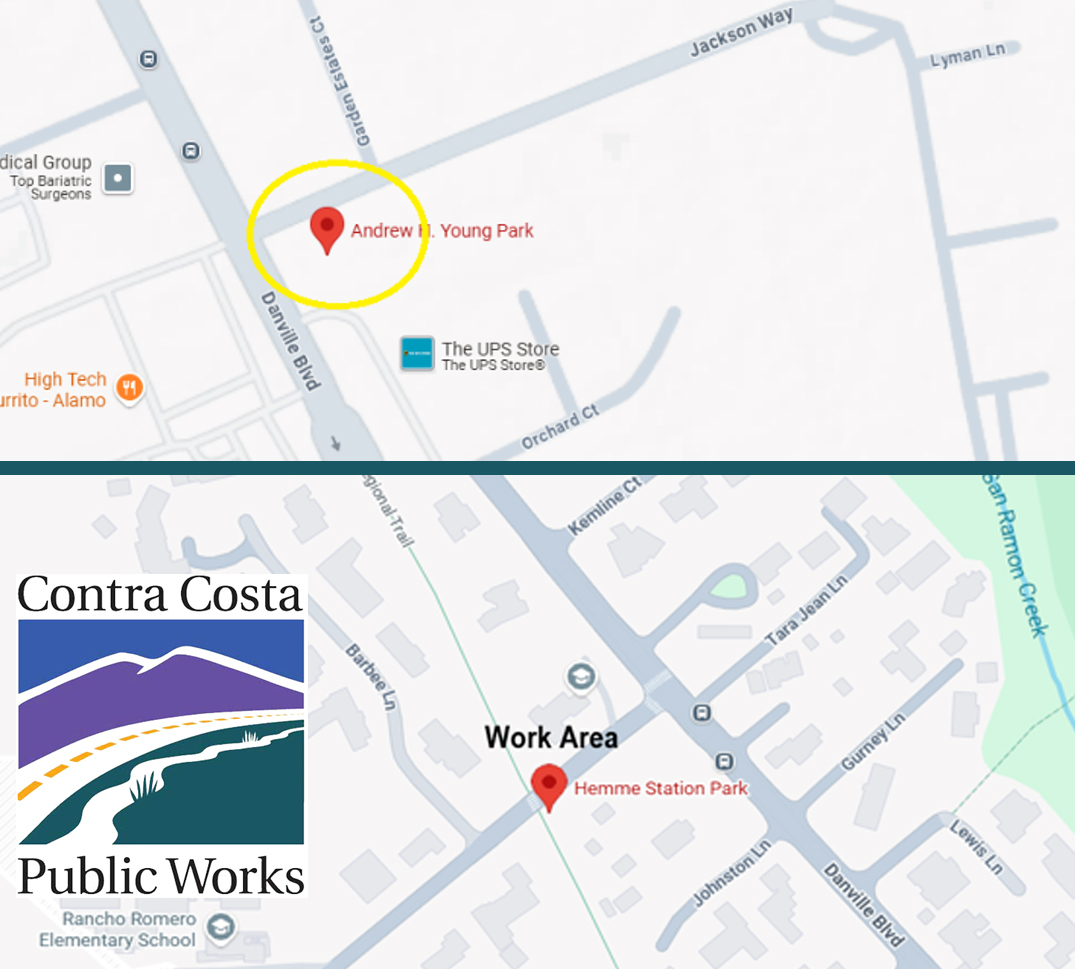
Work area maps. Source: CCC Public Works
By Carrie Ricci, Deputy Director, Contra Costa County Public Works Department
Alamo, CA – A contractor for Contra Costa County Public Works will perform tree pruning at Andrew H. Young Park, located at the corner of Danville Blvd. and Jackson Way in Alamo. Work will be performed on Friday, October 23, 2026, barring unforeseen circumstances. The work will take place between the hours of 8:00 a.m. and 4:00 p.m., weather permitting. The park will not be accessible while work is in progress. The work includes pruning one (1) tree, in preparation for the upcoming Christmas Tree Lighting Festivities.
In addition, a contractor for Contra Costa County Public Works will perform repairs and maintenance to the rubberized surfacing in the play area at Hemme Station Park at Hemme Avenue and Danville Blvd. on Monday, October 26, 2026, from 8:00 a.m. to 4:00 p.m., barring unforeseen circumstances. The play area will remain closed for the remainder of the week and will reopen on Monday, November 2, 2026, weather permitting.
The purpose of this work is to complete repairs and apply treatment to the rubberized surface beneath the play area structures. The play area should not be accessed while the fencing is in place. Walking on the surface during the curing process can affect the finished product. Maintaining the integrity of the newly treated surface is essential to ensuring long-term safety for all park users.
Contra Costa County Public Works appreciates the community’s cooperation and understanding as this essential work is performed.
About Contra Costa County Public Works Department
The Contra Costa County Public Works Department (CCCPWD) is responsible for the maintenance and operation of over 650 miles of roads, 79 miles of streams and channels, and over 150 County buildings. CCCPWD services include parks and recreation, sandbag distribution, flood control, road and facilities maintenance, and storm water management. CCCPWD operates two airports, Buchanan Field Airport in Concord and Byron Airport in Byron. For more information about CCCPWD, please visit us at: www.cccpublicworks.org.
Read More












¡Acompáñanos en nuestro primer Paseo de Halloween en el centro de Richmond!
By Richmond Main Street Initiative
Join us for our first Halloween Stroll in Downtown Richmond!
Take a stroll around The LOT, show off your Halloween costumes, and join us for a Halloween parade starting at 6 PM!
This free, family-friendly event will include:
- Halloween Parade starting at 6 PM
- Slime & Science Station hosted by Chevron, where kids can make monster goo
- Mini pumpkin painting while supplies last
- Trick-or-treating at The LOT and participating local businesses
Bring the family and enjoy Halloween in Downtown Richmond! We hope to see you there!
- Thursday October 29th
- 5 pm to 6:30 pm
- 1401 Macdonald Ave., Richmond, CA.94801 (The LOT)
___________________
¡Acompáñanos en nuestro primer Paseo de Halloween en el centro de Richmond!
Recorre The LOT, luce tu disfraz de Halloween y únete a nuestro desfile de Halloween que comienza a las 6 PM.
Este evento gratuito y familiar incluirá:
- Desfile de Halloween a partir de las 6 PM
- Estación de Ciencia y Slime, presentada por Chevron, donde los niños podrán crear su propio slime monstruoso
- Decoración de mini calabazas, hasta agotar existencias
- Truco o trato en The LOT y en los negocios participantes del centro de Richmond
¡Ven con tu familia y disfruta de Halloween en el centro de Richmond! ¡Esperamos verte allí!
- Jueves 29 de Octubre
- 5 pm to 6:30 pm
- 1401 Macdonald Ave., Richmond, CA.94801 (The LOT)
Presented by the Richmond Main Street Initiative.
The Richmond Main Street Initiative, Inc. is a community-based nonprofit corporation dedicated to revitalizing historic Downtown Richmond as a pedestrian-friendly urban village, offering products, services, arts, and entertainment that reflect the community’s rich and diverse heritage.
For more information visit www.richmondmainstreet.com.
Allen D. Payton contributed to this report.
Read More
Five local bands unite to promote community and civic engagement bringing live music, costumes, community organizations and nonpartisan voter engagement together ahead of the November election.
By Mike Rodriguez, Founder & President, Rage for Democracy
BRENTWOOD, CA — Five local bands will take the stage at the Brentwood Community Center on Friday, October 30, for Night of the Living Loud, an all-ages Halloween rock concert organized by Brentwood-based nonprofit Rage for Democracy.
Sponsored by the City of Brentwood, the event combines live music, a Halloween costume contest, local vendors, community organizations, and nonpartisan civic engagement just days before the November general election.
The lineup features DownbyDown, Dumpster Pyre, Jimmy Party, The Slums, and WheelHouse, bringing together musicians from the local rock and alternative music scene for an evening centered on music, creativity, and community involvement.
Local Musicians Speak Out on Civic Participation
In preparation for the concert, members of the participating bands recently gathered for a meetup, sharing pizza, taking promotional photos, and discussing why voting and community involvement matter to them.
Jouz, singer and guitarist for DownbyDown, emphasized the importance of neighbors supporting one another.
“It’s important to be involved in your community because you want people to look out for you the same way that you would want to look out for them, and vice versa.”
Thomas, guitarist for Dumpster Pyre, spoke about the direct impact voting can have.
“Biggest reason to come out and vote is to have a direct impact on your community and help shape where you are.”
Sebastian, vocalist and guitarist for Jimmy Party, echoed that message.
“Voting is important to get an overall representation of how people feel and getting your voices heard.”
Tyrese, bassist for Dumpster Pyre, offered a straightforward message about participation.
“Think about it this way. Just make a vote. It makes a big change, and that’s all you really need.”
These perspectives reflect the event’s larger goal: helping people recognize that being involved in their communities doesn’t have to begin in a government building or at a political event. Sometimes, it can start with a conversation at a rock show.
Music, Community, and Voter Engagement
Beyond the performances, Night of the Living Loud will feature a Halloween costume contest, band merchandise, local vendors, and tables hosted by community organizations.
Rage for Democracy is also working in partnership with HeadCount, a national nonpartisan nonprofit that promotes voter registration and civic participation through music and live events.
The collaboration reflects a shared belief that music can provide a meaningful connection between young people, their communities, and the democratic process.
The concert is nonpartisan and is not intended to promote any political party or candidate. Instead, the focus is on encouraging individuals to become informed, participate, and recognize the power of their own voices.
The organization is still accepting inquiries from local vendors and businesses interested in participating, providing an opportunity for small businesses, creators, and community groups to connect with concertgoers.
Those interested in vendor spaces, sponsorship opportunities, or community organization participation can contact mike@ragefordemocracy.com for more information.
Building Community Through Music
Rage for Democracy is a Brentwood-based 501(c)(3) nonprofit organization that uses music, civic education, and community service to bring people together.
Its programs include Citizens Civics Club, a free community civics education program; Rage Clean, a volunteer neighborhood cleanup initiative; and the Instrument Closet, a program that makes musical instruments more accessible to the community.
Night of the Living Loud expands on that mission by bringing local musicians, community organizations, businesses, and residents together under one roof.
With the City of Brentwood sponsoring the event’s venue costs, the organization hopes to create an accessible concert experience while supporting the local music scene and introducing attendees to opportunities to get involved in their community.
EVENT INFORMATION
Night of the Living Loud
Friday, October 30, 2026 | 6:00 PM
Brentwood Community Center – 35 Oak Street
Featuring: DownbyDown, Dumpster Pyre, Jimmy Party, The Slums, and WheelHouse
Tickets: $15 in advance | $20 at the door
Admission: All ages
Sponsored by: City of Brentwood
Tickets and additional event information are available at https://www.ragefordemocracy.com.
For vendor inquiries, sponsorship opportunities, or additional information, email mike@ragefordemocracy.com.
About Rage for Democracy
Rage for Democracy is a Brentwood-based 501(c)(3) nonprofit organization dedicated to strengthening communities through nonpartisan civic education, volunteer service, music and creative expression. Guided by the belief that everyone deserves a place to gather, create, connect, and belong, the organization works to make civic and community participation accessible to everyone. www.ragefordemocracy.com.
Read MoreSource: Educational Results Partnership
By Marcus Walton, Director, Communications and Special Projects, Contra Costa County Office of Education
PLEASANT HILL, Calif.— Forty-six schools and six school districts in Contra Costa County have been named to the 2026 California Honor Roll, a recognition presented by Educational Results Partnership (ERP) and the Campaign for Business and Education Excellence.
The recognition highlights schools and districts that are demonstrating strong student achievement, making measurable progress in closing achievement gaps among historically underserved student groups, and improving outcomes for all students. Among the 2,080 schools and 168 districts recognized statewide, Contra Costa County schools and districts continue to stand out for their commitment to student success.
“It is meaningful to see the business community recognize the outstanding work taking place in our schools and districts,” Contra Costa County Superintendent of Schools Lynn Mackey said. “This distinction highlights how public education in Contra Costa County is preparing students to be future ready with the knowledge, skills, and opportunities they need to thrive in college, careers and their communities.”
The six Contra Costa County school districts named to the 2026 California Honor Roll are: Acalanes Union High School District, Brentwood Union School District, Lafayette Elementary School District, Moraga Elementary School District, Orinda Union School District, and San Ramon Valley Unified School District.
The following 46 schools in the county were also honored:
- Campolindo High School — Acalanes Union High School District
- Miramonte High School — Acalanes Union High School District
- Adams (J. Douglas) Middle School — Brentwood Union School District
- Edna Hill Middle School — Brentwood Union School District
- Garin Elementary School — Brentwood Union School District
- Isaac R. Montañez Elementary School — Brentwood Union School District
- R. Paul Krey Elementary School — Brentwood Union School District
- Ron Nunn Elementary School — Brentwood Union School District
- Discovery Bay Elementary School — Byron Union Elementary School District
- Burton Valley Elementary School — Lafayette Elementary School District
- Happy Valley Elementary School — Lafayette Elementary School District
- Lafayette Elementary School — Lafayette Elementary School District
- M. H. Stanley Middle School — Lafayette Elementary School District
- Springhill Elementary School — Lafayette Elementary School District
- Heritage High School — Liberty Union High School District
- Martinez Junior High School — Martinez Unified School District
- Donald L. Rheem Elementary School — Moraga Elementary School District
- Joaquin Moraga Intermediate School — Moraga Elementary School District
- College Park High School — Mt. Diablo Unified School District
- Hidden Valley Elementary School — Mt. Diablo Unified School District
- Monte Gardens Elementary School — Mt. Diablo Unified School District
- Pleasant Hill Middle School — Mt. Diablo Unified School District
- Rocketship Futuro Academy — Rocketship Public Schools
- Sequoia Middle School — Mt. Diablo Unified School District
- Walnut Acres Elementary School — Mt. Diablo Unified School District
- Del Rey Elementary School — Orinda Union School District
- Glorietta Elementary School — Orinda Union School District
- Orinda Intermediate School — Orinda Union School District
- Sleepy Hollow Elementary School — Orinda Union School District
- Wagner Ranch Elementary School — Orinda Union School District
- Alamo Elementary School — San Ramon Valley Unified School District
- Bollinger Canyon Elementary School — San Ramon Valley Unified School District
- Coyote Creek Elementary School — San Ramon Valley Unified School District
- Creekside Elementary School — San Ramon Valley Unified School District
- Diablo Vista Middle School — San Ramon Valley Unified School District
- Golden View Elementary School — San Ramon Valley Unified School District
- Hidden Hills Elementary School — San Ramon Valley Unified School District
- John Baldwin Elementary School — San Ramon Valley Unified School District
- Pine Valley Middle School — San Ramon Valley Unified School District
- Rancho Romero Elementary School — San Ramon Valley Unified School District
- Sycamore Valley Elementary School — San Ramon Valley Unified School District
- Tassajara Hills Elementary School — San Ramon Valley Unified School District
- Tice Creek School — Walnut Creek School District
- Middle College High School — West Contra Costa Unified School District
- Richmond College Preparatory School — West Contra Costa Unified School District
- West County Mandarin School — West Contra Costa Unified School District
Now in its 12th year, the California Honor Roll uses California Assessment of Student Performance and Progress (CAASPP) results from 2024-26 to recognize schools and districts that are driving academic growth and improving student outcomes. The honor highlights educational communities that help students build the foundational skills needed for college, career, and life.
According to ERP, the Honor Roll identifies schools that are helping students build the foundational skills needed for college, career and life. ERP partners with business leaders and chambers of commerce throughout California to recognize schools and districts making measurable progress in student achievement. The Honor Roll is the only school recognition program presented in partnership with business leaders and based solely on student achievement outcomes.
To view the full list of California Honor Roll schools and districts, visit www.honorrollschools.com.
About Educational Results Partnership
Educational Results Partnership (ERP) is a nonprofit organization that applies data science and predictive analytics to identify successful public education systems, practices, programs, and policies that deliver the best results for students. ERP has accumulated the nation’s largest database on student achievement from kindergarten into the labor market. In partnership with educators and employers, ERP charts the pathways that lead to academic success and living-wage jobs. ERP’s goal is to ensure that more students are equipped to enter the workforce with the skills today’s global economy demands. For more information visit: edresults.org.
About Campaign for Business and Education Excellence
The Campaign for Business and Education Excellence (CBEE) aims to improve economic mobility for the next generation of learners by matching talent to jobs and career opportunities. Aligning academic achievements with job market needs, the campaign engages employers while helping learners pursue careers matched to their existing skills and abilities. Learners across the United States can discover how their education opens doors to immediate career opportunities. For more information visit: edcampaign.org.
About Contra Costa County Office of Education
One of 58 counties in California, Contra Costa County has the 11th largest public-school student population in the state (approximately 169,225 students). Officially established in 1932, CCCOE has a long history of providing direct services to some of the county’s most vulnerable students, including young people who are incarcerated, homeless, or in foster care, as well as students who have severe physical or emotional challenges.
CCCOE also provides support services to schools and school districts in Contra Costa County; services that can be handled most effectively and economically on a regional basis rather than by each of the county’s 286 schools or 18 school districts. These services range from budget approval and fiscal support to technology infrastructure, communication support, and high-level professional development opportunities for educators. CCCOE maintains a website at www.cocoschools.org.
Read More
To prohibit election intimidation in compliance with state laws in response to concerns Pres. Trump is trying to influence results
By Dawn Kruger Community and Media Relations Coordinator Contra Costa County Clerk-Recorder-Elections Department
Martinez, California – As voting gets underway for the November 3rd General Election, Contra Costa County’s Clerk-Recorder and Registrar of Voters, District Attorney and Sheriff are standing together to ensure every voter can cast a ballot safely and with confidence.
California has long led the nation in protecting the right to vote, and its election safeguards keep getting stronger. The Peace Act (AB 2642), signed into law in September 2024, established clear protections for voters and election workers in all 58 counties by explicitly prohibiting intimidation and threats at the polls. It treats the presence of a firearm, or even a replica of one, at a polling place as unlawful intimidation, and it gives voters, election officials, and election workers the right to take civil legal action against anyone who tries to intimidate or coerce them.
Legislation signed by Governor Gavin Newsom this September builds on that foundation. The new laws make it a felony to tamper with ballots, election records, or voting equipment, guard voters against deepfakes and deception, and expand access to the ballot box, giving election and law enforcement officials across the state more tools to keep elections safe, secure, and fair. For Contra Costa County voters, that means every ballot, whether cast at a polling place, dropped in a drop box, or returned by mail, is protected from the moment it’s cast until the final count.
In his signing statement Newsom said, “Donald Trump won’t stop until he can exert dictatorial control over your free vote and disenfranchise millions of people this November. California will stop him at every opportunity. We have no bigger task than fighting to protect the right to vote from interference and meddling – the future of democracy is on the line. These bills today build upon the wall California has built to safeguard our electoral process.”
Contra Costa voters can vote their way with confidence, say the three County officials.
“As the Chief Elections Officer for Contra Costa County, I want to encourage all eligible Contra Costa residents to vote and to know that we expect another safe and secure election,” said Kristin B. Connelly, Clerk-Recorder and Registrar of Voters. “I also want to reassure voters that we take extensive safety precautions in every election. We partner closely with local law enforcement to ensure that all Contra Costa Voters can feel confident voting with their preferred method either by drop box, through the post office, or in-person.”
Contra Costa District Attorney Diana Becton said, “Your vote is your voice, and we will protect it. From the mailbox to the drop box to the polling place, my office and our law enforcement partners are making sure every eligible voter in Contra Costa County can cast a ballot freely, safely, and with confidence that their voice will be heard.”
“As the election approaches, the Contra Costa Sheriff’s Office is working with its law enforcement partners to ensure this election is safe and that we will help protect residents’ right to vote,” said Sheriff David Livingston.
However, the Contra Costa County Elections Division still uses the controversial Dominion voting equipment purchased in 2018 that has removal flash drives, as well as Scytle software. (See related articles here, here and here)
Since then, Dominion Voting Systems, a Canadian company, was purchased in 2025 by election reform advocate Scott Leiendecker under a new company called Liberty Vote based in Denver, Colorado.
For more information on how or where to vote, visit the Contra Costa County Elections website www.contracostavote.gov.
Allen D. Payton contributed to this report.
Read MoreRichmond Promise Executive Director Christopher Whitmore (center) with Contra Costa County Superintendent of Schools Lynn Mackey (right) and members of the Contra Costa County Board of Education, (L-R) President Sarah Butler, Daniel Nathan-Heiss, Vice President Yazmin Llamas, Mike Maxwell, Annette Lewis and student members, Melanie Hernandez-Rios and Valeria Gonzalez-Sandoval. Photo: CCCOE
By Marcus Walton, Director, Communications and Special Projects, Contra Costa County Office of Education
PLEASANT HILL, Calif.— Contra Costa County Superintendent of Schools Lynn Mackey and the County Board of Education recognized Richmond Promise for a decade of helping students in Richmond pursue higher education and career opportunities.
Since its founding in 2016, Richmond Promise has awarded more than $14 million in scholarships to students, according to the organization. Among scholarship recipients, 91% identify as people of color or Indigenous, and 64% are the first in their families to pursue higher education.
“Students in our county need Education Champions like Richmond Promise to make connections and give them a leg up to pursue their dreams,” Contra Costa County Superintendent of Schools Lynn Mackey said. “Programs that provide scholarships and pathways to higher education or job training are the lifelines our kids need, and we need more of them. Thank you to Executive Director Christopher Whitmore, his team, and the Richmond Promise Board of Directors for 10 years of investing in future leaders.”
Richmond Promise is a communitywide college success initiative dedicated to expanding access to higher education for Richmond students and supporting them throughout their academic journeys. Through scholarships, student success programs and partnerships with local organizations, the nonprofit works to build a culture that encourages college enrollment, persistence, and graduation.
The organization’s approach begins with early college awareness and continues through financial literacy, college access, and college completion. Through scholarships, financial aid support, workshops, coaching, career mentorship and peer networks, Richmond Promise helps students navigate the path to higher education and career success.
By connecting students with resources and opportunities, Richmond Promise aims to remove barriers to educational attainment while helping develop future leaders who can contribute to and strengthen their communities.
The Education Champion Award recognizes community partners that demonstrate an exceptional commitment to supporting students, schools and educational programs across Contra Costa County. Honorees help expand opportunities, strengthen community connections, and provide resources that support public education.
About Contra Costa County Office of Education
One of 58 counties in California, Contra Costa County has the 11th largest public-school student population in the state (approximately 169,225 students). Officially established in 1932, CCCOE has a long history of providing direct services to some of the county’s most vulnerable students, including young people who are incarcerated, homeless, or in foster care, as well as students who have severe physical or emotional challenges.
CCCOE also provides support services to schools and school districts in Contra Costa County; services that can be handled most effectively and economically on a regional basis rather than by each of the county’s 286 schools or 18 school districts. These services range from budget approval and fiscal support to technology infrastructure, communication support, and high-level professional development opportunities for educators. CCCOE maintains a website at www.cocoschools.org.
Read MoreSource: CCC Superior Court
Ends midday call-ins, reduces number of jurors summoned, aligns with most Bay Area courts
By Dan Radovich, ADA and Communications Manager, Contra Costa County Superior Court
MARTINEZ, Calif. – Beginning January 4, 2027, the Contra Costa County Superior Court will transition to a weekly jury summons model. Residents will be summoned for jury service less often under this new model, which is projected to reduce the number of jurors summoned each year by approximately 20%. The change also eliminates midday call-ins. Instead, jurors will know the day before whether they need to report. The first summonses under the weekly model will be mailed beginning November 9, 2026.
The change results, in part, from the Court’s strategic planning process and the feedback residents provided about their experience with jury service in Contra Costa County. The Court reviewed its jury operations and historical data, identifying weekly summonsing as a practical way to make jury service less disruptive. Weekly summonsing also brings the Court in line with most other Bay Area courts, which already summon jurors by the week.
What the Change Means for Jurors
Residents will be summoned for a service week instead of a single day. Under the Court’s new model:
- A full day’s notice. Jurors will check their reporting instructions by 5:00 p.m. beginning the court day before their service week. Jurors who are not asked to report must continue to check their reporting instructions each court day until their service week ends.
- Service is complete if not asked to report during service week. Jurors who are not asked to report during their service week will have fulfilled their jury service and will not be summoned again for at least 12 months.
Service weeks will begin on Monday, or Tuesday when Monday is a court holiday. Under the current system, jurors are often instructed to call in at 11:30 a.m. and then asked to report by 1:00 p.m. that afternoon. The new weekly model eliminates midday call-ins and same-day reporting. However, it does not change what happens when jurors report. Under the statewide “one day or one trial” policy, jurors
who report and are not assigned to a courtroom will complete their jury service that same day. Jurors assigned to a courtroom for jury selection or impaneled on a trial will return as directed by the judge.
Expected Impact
In 2025, the Court mailed over 305,000 jury summonses to support more than 250 criminal, civil, and probate jury trials. Weekly summonsing allows Jury Services to better match the number of jurors asked to report with courtroom needs on a given day. Based on its analysis of 2025 data, the Court projects the model will:
- Reduce the number of annual summonses by approximately 61,000.
- Save approximately $31,000 a year in printing and postage costs.
The Court will evaluate actual results following implementation, including summons volume, failure-to-appear rates, juror utilization, and courthouse operations.
“Jury service is an important civic responsibility, but we also recognize that it can be challenging to fit into work, family, and other obligations,” said Sarah Lind, Court Executive Officer and Jury Commissioner. “This new model is a meaningful step toward making jury service more predictable and manageable for residents, while continuing to meet the needs of our courtrooms.”
Jurors will continue to have the option to receive their reporting instructions by text message or email. Additional information about the Court’s new jury summons model and instructions for signing up for text message and email notifications are available on the Juror Service Center page of the Court’s website: contracosta.courts.ca.gov/jury. Jury Services may be contacted by phone at (925) 608-1001.
Read MoreAVAIO Digital data center rendering and Mayor Dionne Adams official photo. Source: City of Pittsburg
PITTSBURG, CA — Mayor Dionne Adams issued the following statement today, Thursday, Oct. 22, 2026:
On Monday, October 26, the Pittsburg City Council will consider a 45-day emergency moratorium on future data center development, including Phases II and III of the AVAIO project. This follows months of residents speaking up, asking questions and sharing concerns about what data centers mean for their families and neighborhoods.
Although my employer’s involvement has required me to recuse myself from recent project-related decisions, my responsibility to listen to residents and help ensure their questions are answered has remained central to my work as Mayor.
For the last few months, I directed the City Manager and staff to expand their outreach across the City, online and in-person, and called for a dedicated Council meeting focused entirely on data centers – where the creation of a community advisory council followed. More recently, I’ve routinely requested formal updates from the City Manager to the public, all of this ultimately leading to the upcoming moratorium vote.
The City’s advisory council is currently developing recommendations for future data center policies, and the Council’s upcoming moratorium vote will enable council to complete that work.
Pittsburg is my home, too. As our understanding of data centers and AI infrastructure evolves, we have a responsibility to keep learning and responding to the people whose lives and neighborhoods are affected. I won’t get every decision right, but I will always listen, take your concerns seriously, and do what I believe is in the best interests of Pittsburg and its residents, even when I cannot vote on every individual item.
To everyone who has taken the time to speak with me, attend a meeting or ask a difficult question: thank you. You deserve a City government that hears you and responds.
Monday’s meeting agenda has not yet been published on the City’s website. Please check the Agendas and Minutes page, later, here: Pittsburg, CA – Agendas & Minutes.
Allen D. Payton contributed to this report.
Read MoreMontalvin Park Playground Work Area Map. Source: CCC Public Works
By Carrie Ricci, Deputy Director, Contra Costa County Public Works Department
Unincorporated Contra Costa County, CA – A contractor for Contra Costa County Public Works will perform maintenance to the rubberized surfacing in one of the play areas at Montalvin Park, located between San Pablo and Hercules in West County, on Wednesday, October 28, 2026, between 8:00 a.m. and 4:00 p.m., barring unforeseen circumstances. The play area will remain closed for the remainder of the week with access restored on Wednesday, November 4, 2026, weather permitting.
The purpose of this work is to apply treatment to the rubberized surface beneath the play area structures. The play area should not be accessed while the fencing is in place. Walking on the surface during the curing process can affect the finished product. Maintaining the integrity of the newly treated surface is essential to ensuring long-term safety for all park users.
Contra Costa County Public Works appreciates the community’s cooperation and understanding as this essential work is performed.
About Contra Costa County Public Works Department
The Contra Costa County Public Works Department (CCCPWD) is responsible for the maintenance and operation of over 650 miles of roads, 79 miles of streams and channels, and over 150 County buildings. CCCPWD services include parks and recreation, sandbag distribution, flood control, road and facilities maintenance, and storm water management. CCCPWD operates two airports, Buchanan Field Airport in Concord and Byron Airport in Byron. For more information about CCCPWD, please visit us at: www.cccpublicworks.org.
Read MoreBig Oak Tree Park, Clyde Work Area Map. Source: CCC Public Works
By Carrie Ricci, Deputy Director, Contra Costa County Public Works Department
Clyde, CA – A contractor for Contra Costa County Public Works will perform repairs and maintenance to the rubberized surfacing in the play area at Big Oak Tree Park on Tuesday, October 27, 2026, between 8:00 a.m. and 4:00 p.m., barring unforeseen circumstances. The play area will remain closed for the remainder of the week and will reopen on Tuesday, November 3, 2026, weather permitting.
The purpose of this work is to complete repairs and apply treatment to the rubberized surface beneath the play area structures. The play area should not be accessed while the fencing is in place. Walking on the surface during the curing process can affect the finished product. Maintaining the integrity of the newly treated surface is essential to ensuring long-term safety for all park users.
Contra Costa County Public Works appreciates the community’s cooperation and understanding as this essential work is performed.
About Contra Costa County Public Works Department
The Contra Costa County Public Works Department (CCCPWD) is responsible for the maintenance and operation of over 650 miles of roads, 79 miles of streams and channels, and over 150 County buildings. CCCPWD services include parks and recreation, sandbag distribution, flood control, road and facilities maintenance, and storm water management. CCCPWD operates two airports, Buchanan Field Airport in Concord and Byron Airport in Byron. For more information about CCCPWD, please visit us at: www.cccpublicworks.org.
Read MoreWork area maps. Source: CCC Public Works
By Carrie Ricci, Deputy Director, Contra Costa County Public Works Department
Alamo, CA – A contractor for Contra Costa County Public Works will perform tree pruning at Andrew H. Young Park, located at the corner of Danville Blvd. and Jackson Way in Alamo. Work will be performed on Friday, October 23, 2026, barring unforeseen circumstances. The work will take place between the hours of 8:00 a.m. and 4:00 p.m., weather permitting. The park will not be accessible while work is in progress. The work includes pruning one (1) tree, in preparation for the upcoming Christmas Tree Lighting Festivities.
In addition, a contractor for Contra Costa County Public Works will perform repairs and maintenance to the rubberized surfacing in the play area at Hemme Station Park at Hemme Avenue and Danville Blvd. on Monday, October 26, 2026, from 8:00 a.m. to 4:00 p.m., barring unforeseen circumstances. The play area will remain closed for the remainder of the week and will reopen on Monday, November 2, 2026, weather permitting.
The purpose of this work is to complete repairs and apply treatment to the rubberized surface beneath the play area structures. The play area should not be accessed while the fencing is in place. Walking on the surface during the curing process can affect the finished product. Maintaining the integrity of the newly treated surface is essential to ensuring long-term safety for all park users.
Contra Costa County Public Works appreciates the community’s cooperation and understanding as this essential work is performed.
About Contra Costa County Public Works Department
The Contra Costa County Public Works Department (CCCPWD) is responsible for the maintenance and operation of over 650 miles of roads, 79 miles of streams and channels, and over 150 County buildings. CCCPWD services include parks and recreation, sandbag distribution, flood control, road and facilities maintenance, and storm water management. CCCPWD operates two airports, Buchanan Field Airport in Concord and Byron Airport in Byron. For more information about CCCPWD, please visit us at: www.cccpublicworks.org.
Read More