• Home
  • About The Herald
  • Local Agencies
  • Daily Email Update
  • Legal Notices
  • Classified Ads

Contra Costa Herald

News Of By and For The People of Contra Costa County, California

  • Arts & Entertainment
  • Business
  • Community
  • Crime
  • Dining
  • Education
  • Faith
  • Health
  • News
  • Politics & Elections
  • Real Estate

Bay Bridge Forward commute initiative to reduce traffic in region’s most congested corridor

September 17, 2026 By Publisher Leave a Comment

Source: MTC

A set of investments, projects and strategies to improve efficiency, reduce delays and move more people and buses across the most-traveled bridge in the Bay Area.

By Metropolitan Transportation Commission

The San Francisco-Oakland Bay Bridge (Bay Bridge) corridor is a vital lifeline for commuter and business travel to and from the City of San Francisco and the East Bay.  It is consistently ranked the most congested corridor in the region. Severe traffic congestion occurs on the approaches to the bridge, especially in the morning commute hours. Vehicles spend more hours delayed approaching the Bay Bridge than on all the other Bay Area east-west crossings combined.  At times, this congestion prevents high-occupancy vehicles (HOVs) and buses from accessing the existing by-pass lanes at the toll plaza – and is worse than the congestion on the bridge itself.  At the same time, high rates of people driving alone and lower transit ridership means that more than half of the seats in vehicles crossing the Bay Bridge are empty.

The Bay Bridge Forward Program proposes solutions that would increase the number of people moving through the area by filling empty seats. This would improve operations and reduce congestion without hefty capital investments. Bay Bridge Forward includes a suite of projects to: improve transit travel time and reliability; promote carpooling and transit ridership; increase the number of people who can move through the corridor (person throughput); and reducing greenhouse gas emissions.

Project 6 – Interstate 80, Bay Bridge & Carquinez Bridge HOV Lane Hours of Operation

Source: MTC

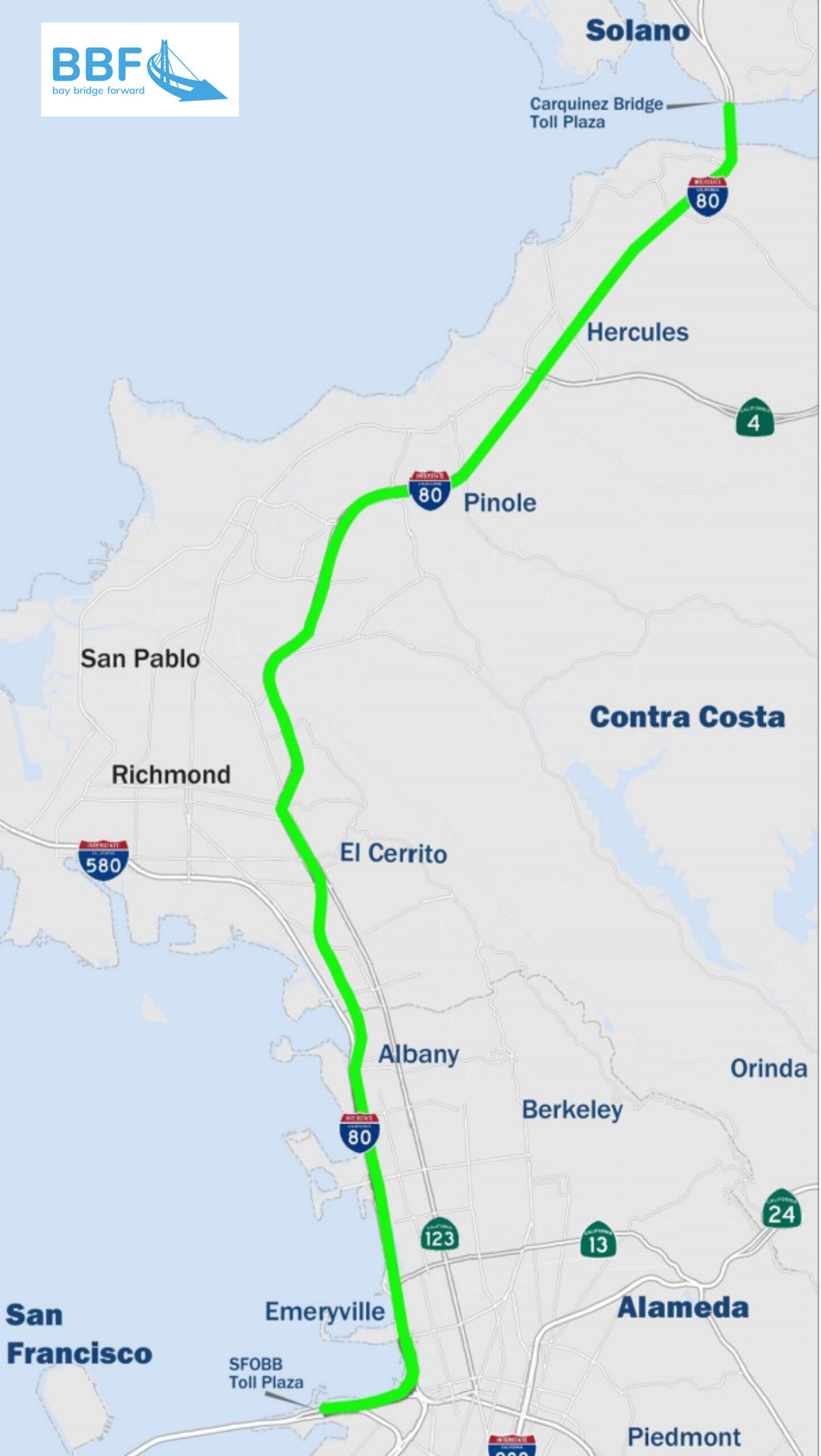
Part of the Bay Bridge Forward commute initiative, the Interstate 80, Bay Bridge & Carquinez Bridge HOV Lane Hours of Operation is one of several projects that aim to improve traffic congestion for the Interstate 80 (I-80) corridor between the Carquinez Bridge and the San Francisco-Oakland Bay Bridge.

  • Overview

This project is evaluating extended hours of operation of the high-occupancy vehicle (HOV) lanes along the Interstate 80 corridor between the San Francisco-Bay Bridge and the Carquinez Bridge and at the approaches to both bridges.

While the corridor experiences significant congestion beyond traditional peak periods, the current HOV hours of operation are limited to weekdays between 5 a.m. and 10 a.m. and between 3 p.m. and 7 p.m. Project 6a’s analysis and implementation will evaluate expanding the hours to include midday and weekend operations.

This project aims to:

  • Provide more reliable travel times for transit riders and carpools during periods of prevalent midday and weekend congestion; and
  • Encourage transit use and carpooling.
  • Project Schedule

As of the latest update in April 2026, the estimated completion dates for the Traffic Analysis is 2026, for Final Design is 2027 and for Construction is 2028.

Project 6 – Interstate 80 HOV Lane Access Restrictions

Also part of the Bay Bridge Forward commute initiative, the Interstate 80 HOV Lane Access Restrictions is one of several projects that aim to improve traffic congestion for the Interstate 80 (I-80) corridor between the Carquinez Bridge and the San Francisco-Oakland Bay Bridge.

  • Overview

This project proposes to implement access restrictions along select segments of the existing high-occupancy vehicle (HOV) lanes on the Interstate 80 corridor between the San Francisco-Oakland Bay Bridge and the Carquinez Bridge. Access restrictions are expected to improve traffic flow in the HOV and general purpose lanes by limiting merges between lanes in congested areas.

Currently, the HOV lane is separated from general traffic by a dashed line, which indicates that it is OK to enter and exit the HOV lane at any point. Project 6b would add lane access restrictions by replacing the existing lane striping and painting double solid white lines between the existing HOV lane and the general-purpose lane, to restrict vehicles from entering or exiting the HOV lanes at select segments. Double white lines indicate it is illegal to enter and exit the lane.

  • Project Schedule

As of April 20226, the Project Initiation Document was completed in April 2026, and the estimated completion date for the Project Approval & Environmental Document is sometime this year, the Final Design in 2027 and Construction in 2028.

Project 6 – Interstate 580 Westbound to Interstate 80 Eastbound Connector Bus Lane

The Interstate 580 Westbound to Interstate 80 Eastbound Connector Bus Lane is one of several projects of the Bay Bridge Forward commute initiative that aim to improve traffic congestion for the Interstate 80 (I-80) corridor between the Carquinez Bridge and the San Francisco-Oakland Bay Bridge.

  • Overview

The Interstate 80 (I-80) Bus-on-Shoulder Feasibility Analysis assessed the feasibility of pursuing bus-on-shoulder or bus lane segments on or connecting to I-80, and identified potential segments to move into project development.

One of the segments moving forward is the Interstate 580 (I-580) westbound to I-80 eastbound Connector Bus Lane. This project would construct a bus-only lane by reducing the existing right and left shoulders on the westbound I-580 to eastbound I-80 direct connector ramp. The project aims to:

  • Reduce bus delays;
  • Provide travel time reliability for buses; and
  • Encourage the use of public transit in this congested segment.
  • Project Schedule

The Feasibility Analysis was completed in Summer 2025; the Project Initiation Document (PID) is expected to be completed sometime in 2026 and the estimated completion date for Project Approval & Environmental Document and Final Design is in 2027 and Construction in 2029.

Project 6 – Interstate 80 Localized Transit Priority/HOV Strategies

Source: MTC

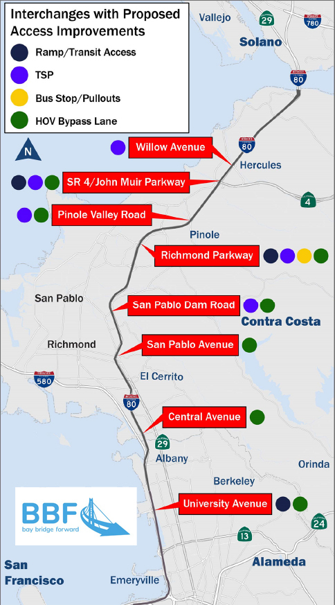
Part of the Bay Bridge Forward commute initiative, Interstate 80 Localized Transit Priority/HOV Strategies is one of several projects that aim to improve traffic congestion for the Interstate 80 (I-80) corridor between the Carquinez Bridge and the San Francisco-Oakland Bay Bridge.

  • Overview

The Interstate 80 (I-80) Localized Transit Priority/HOV Strategies project aims to enhance access to HOV preferential lanes and/or add transit signal priority (TSP) equipment at nine interchange locations.

The project is intended to:

  • Provide travel time savings for carpools and buses; and
  • Increase bus system reliability.
  • Project Schedule

The Preliminary Analysis was completed in Summer 2025; the estimated completion date for the Project Initiation Document (PID) is sometime in 2026, Project Approval/Environmental Document (PA/ED) in 2027, Final Design in 2028 and Construction in 2029.

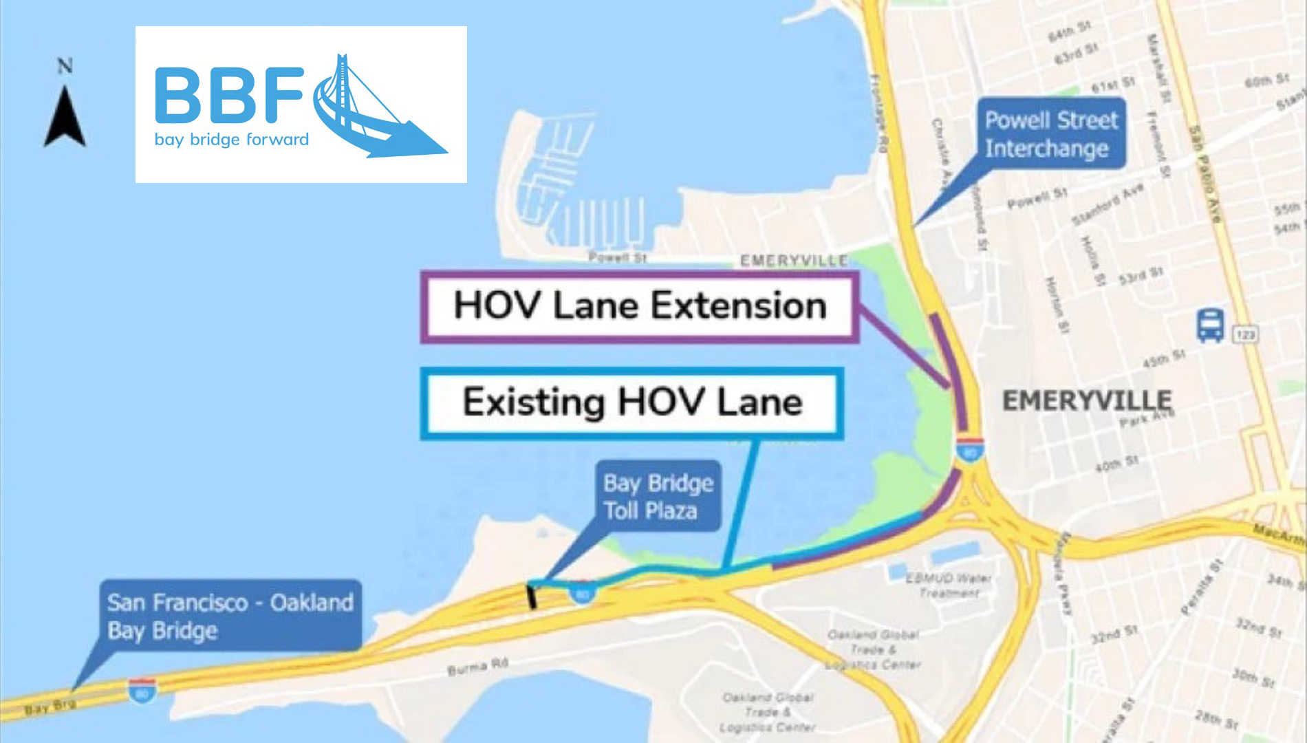
Project 2 – Interstate 580 Westbound HOV Lane Extension

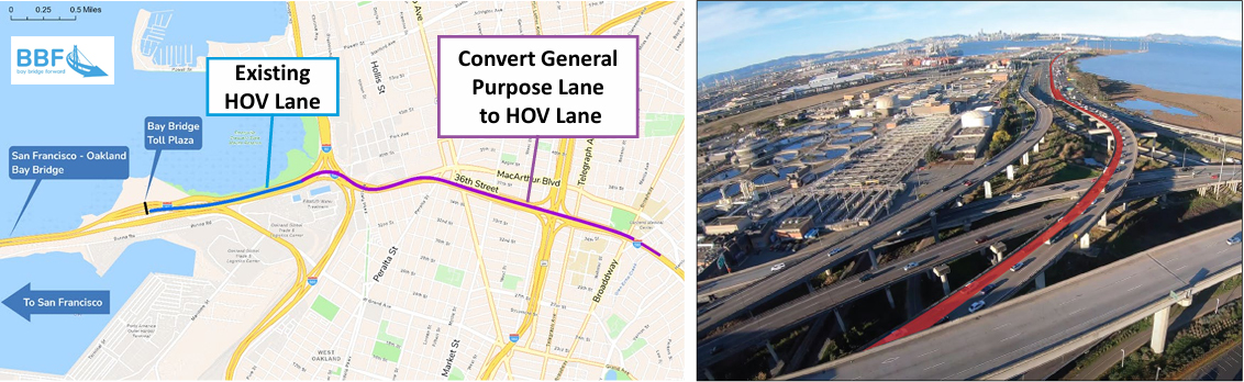
The Bay Bridge Forward’s Interstate 580 Westbound HOV Lane Extension project proposes to extend the existing high-occupancy vehicle (HOV) lane on westbound Interstate 580 to reduce traffic backup during morning peak hours.

Source: MTC

  • Overview

The Interstate 580 (I-580) westbound corridor serves as an approach to the San Francisco-Oakland Bay Bridge and is a key transbay commute corridor that connects the East Bay to San Francisco.

The corridor experiences heavy traffic congestion during morning peak hours, with traffic backing up to the Interstate 980 (I-980)/State Route 24 (SR-24) interchange.

MTC – in partnership with Alameda County Transportation Commission – proposes to extend the existing HOV lane on I-580 westbound to the area by the I-980/SR-24 interchange as a near-term improvement.

The I-580 Westbound HOV Lane Extension Project seeks to:

  • Move more people through the corridor during peak hours.
  • Improve travel time reliability to support buses and HOVs.
  • Provide time travel savings for HOV and transit users, to encourage people to carpool or take transit.

The project proposes to convert a portion of the far-left lane of westbound I-580 to an HOV lane. From just east of the Piedmont Avenue undercrossing in Oakland, the new HOV lane would connect with the existing HOV lane at the toll plaza approach (just west of the MacArthur maze), a distance of approximately 2.3 miles.

  • Project Schedule

The Preliminary Engineering and Environmental Studies were completed in June 2024, Final Design was completed in October 2024, and Construction is estimated to be completed in 2027.

Source: MTC

Project 3 – Interstate 80/Powell Street Interchange Transit Access Improvements

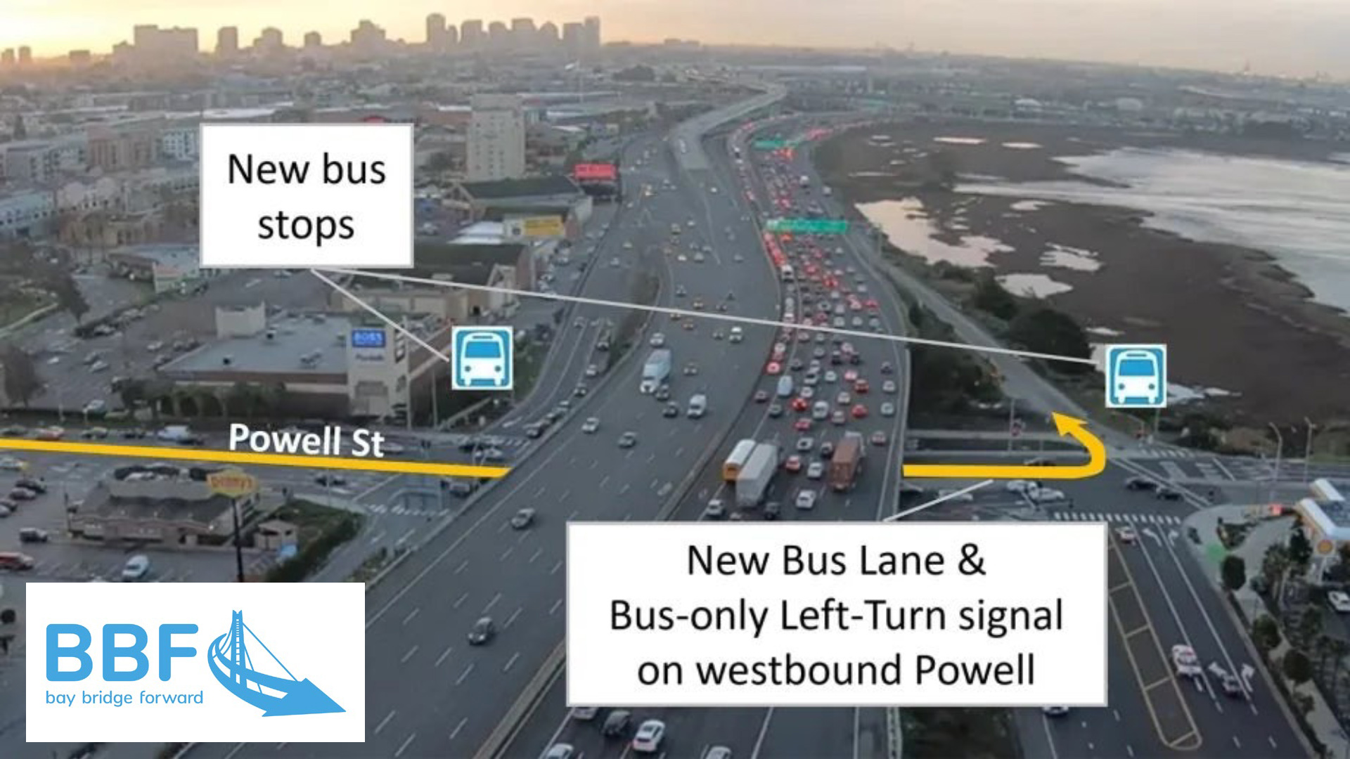
Another part of the Bay Bridge Forward commute initiative, the Interstate 80/Powell Street Interchange Transit Access Improvements project aims to improve traffic flow during morning peak commute hours for transit vehicles that enter and exit Interstate 80 through Powell Street.

  • Overview

The Interstate 80 (I-80)/Powell interchange currently services multiple transbay bus routes including Alameda-Contra Costa Transit District (AC Transit) lines and the Capital Corridor (Amtrak) connecting bus between Emeryville Station and San Francisco.

The existing transit route on the West Frontage Road and I-80 Powell Street loop on-ramp are highly congested during morning peak commute hours. This project is needed to improve vehicle flow and reliability for transit vehicles that enter and exit I-80 through Powell Street.

MTC – in partnership with Alameda County Transportation Commission, the City of Emeryville and AC Transit – is proposing transit facility improvements within the I-80 Powell Street interchange to:

  • Improve transit reliability and travel time;
  • Improve transit accessibility;
  • Promote safety for transit riders; and
  • Encourage transit use.

The improvements include:

  • The construction of a dedicated transit lane on Powell Street;
  • New bus stops with improved pedestrian and bicycle access; and
  • Dedicated transit-only signals and detectors at the ramp intersections to facilitate transit priority.
  • Project Schedule

Preliminary Engineering & Environmental Studies were completed in July 2023, Final Design was estimated to be completed in Summer 2026, but completion of Construction is To Be Determined as of April 27, 2026.

Source: MTC

Project 4 – Interstate 80 Westbound HOV/Bus Lane

The Bay Bridge Forward’s Interstate 80 Westbound HOV/Bus Lane project proposes adding a high-occupancy vehicle (HOV) lane to westbound Interstate 80 (I-80) between the Powell Street Interchange and the Bay Bridge toll plaza.

  • Overview

The Interstate 80 (I-80) westbound HOV lane and the HOV connector ramp (also known as the I-80 flyover ramp) serves HOV traffic on the I-80 corridor. The I-80 flyover ramp provides a direct connection to the San Francisco-Oakland Bay Bridge toll plaza, allowing buses and HOVs to bypass a major bottleneck north of the I-80/I-880/I-580 junction. Heavy traffic congestion in the vicinity of the I-80 Powell Street interchange can prevent buses and HOVs from accessing the I-80 flyover ramp.

MTC – in partnership with Alameda County Transportation Commission – proposes adding an HOV lane to the outside of the westbound I-80 between Powell Street Interchange and the Bay Bridge toll plaza. This project will benefit transit vehicles entering from the Powell Street interchange, as well as other HOVs traveling on westbound I-80 that cannot use the existing leftmost HOV lane due to congestion. This project seeks to:

  • Improve the operational efficiency and travel time for buses and HOVs on westbound I-80;
  • Move more people through the area during peak hours; and
  • Encourage carpooling and transit use.
  • Project Schedule

The Preliminary Engineering was completed in July 2025 and the estimated completion date for Environmental Studies is To Be Determined.

Source: MTC

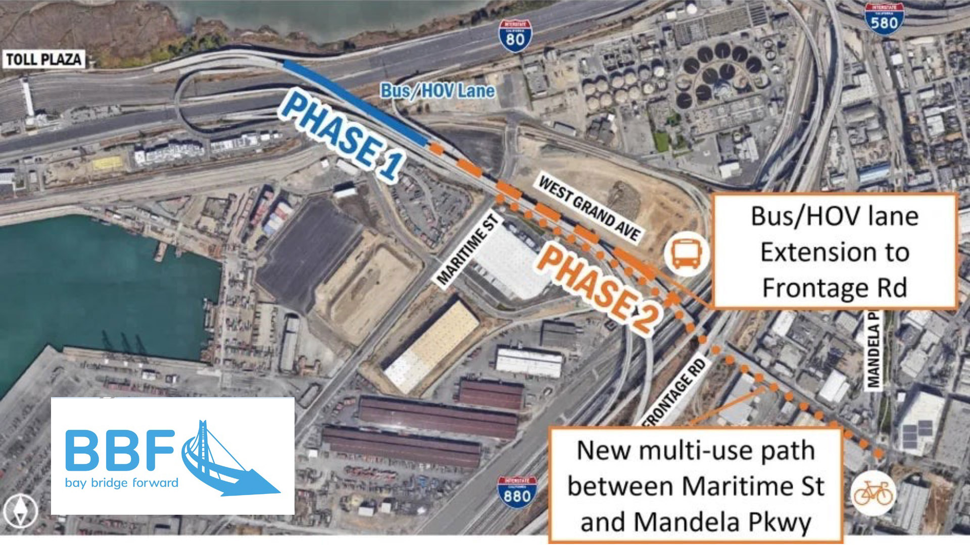
Project 1 – West Grand Avenue Bus & High Occupancy Vehicle Lane

The Bay Bridge Forward’s West Grand Avenue Bus & High Occupancy Vehicle Lane project will construct a dedicated westbound bus and carpool lane on West Grand Avenue for travelers approaching the San Francisco-Oakland Bay Bridge.

  • Overview

In 2016, MTC – in partnership with Caltrans and the City of Oakland – proposed the construction of a dedicated bus and carpool lane on West Grand Avenue to improve the travel time for buses and carpoolers approaching the Bay Bridge toll plaza from West Grand Avenue.

The project is separated into two phases.

  • Phase 1: Complete

In 2019, the first phase was constructed, which created a high-occupancy vehicle (HOV) lane on the Interstate 80 (I-80) West Grand Avenue on-ramp. It converted approximately 1,300 feet of right shoulder into a bus/HOV lane.

The bus/HOV lane is open to buses 24 hours a day, seven days a week. HOVs with three or more occupants are allowed to use the lane during weekday peak hours, 5 a.m. to 10 a.m. and 3 p.m. to 7 p.m.  The new HOV lane has provided substantial travel time savings for buses and HOVs, bypassing congestion during the morning peak period.

  • Phase 2: In Progress

As of April 2026, development of the second phase is currently underway. It will extend the existing bus/HOV lane from its current terminus on the West Grand Avenue on-ramp further east to Frontage Road. This would allow buses to bypass a major queue on West Grand Avenue. The new bus/HOV lane will be open to HOVs with three or more occupants during the weekday peak hours (5 a.m. to 10 a.m. and 3 p.m. to 7 p.m.).

Phase two of the project also proposes to construct a class I multi-use path on the south side of West Grand Avenue to close a 0.7-mile gap in the existing West Oakland bicycle network. The multi-use path would provide a key connection to the existing class I multi-use path on Maritime Street to the west and class II bike lanes on Mandela Parkway to the east of the project area.

Phase two construction is expected to begin in 2027. When completed, the project will bring additional benefits for carpools, buses, pedestrians and bicyclists.

  • Project Schedule

Phase 1 Construction was completed in 2019, Phase 2 Preliminary Engineering and Environmental Studies were completed in Summer 2023, Phase 2 Final Design is expected to be completed sometime in 2026 and Phase 2 Construction in winter 2027.

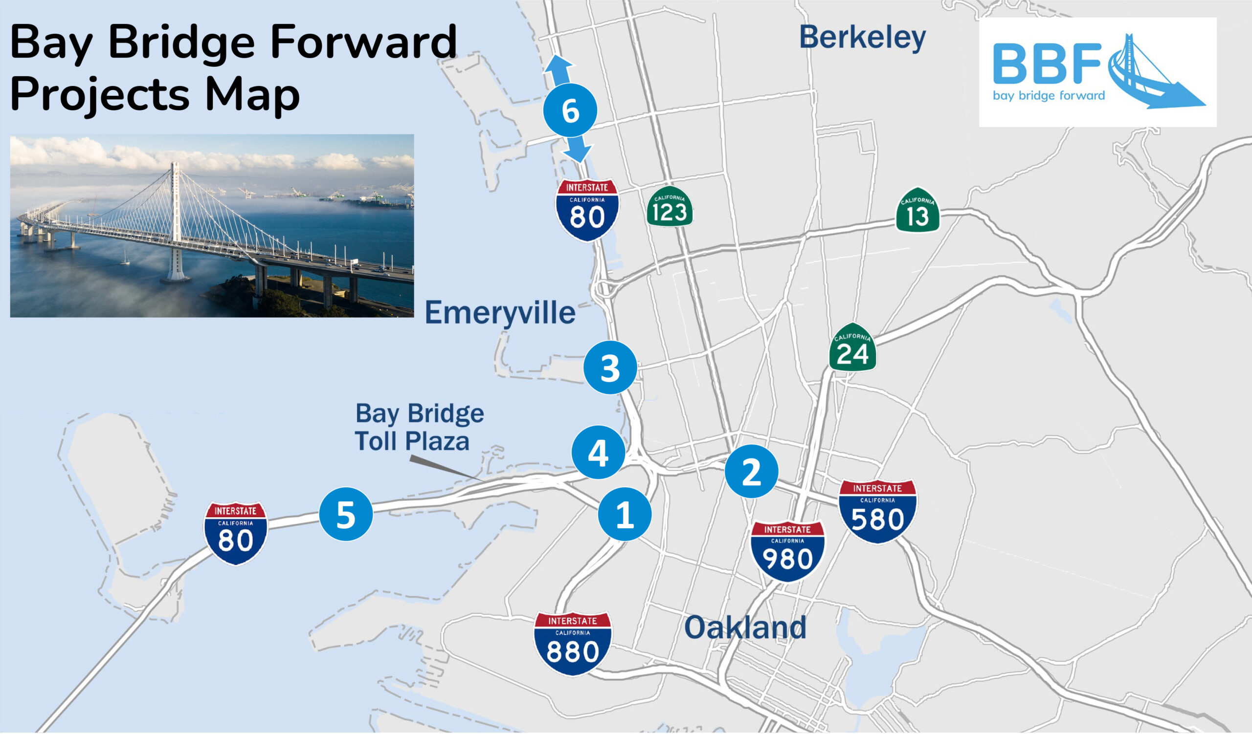
See an expanded version of the Bay Bridge Forward program projects map. Project details are below.

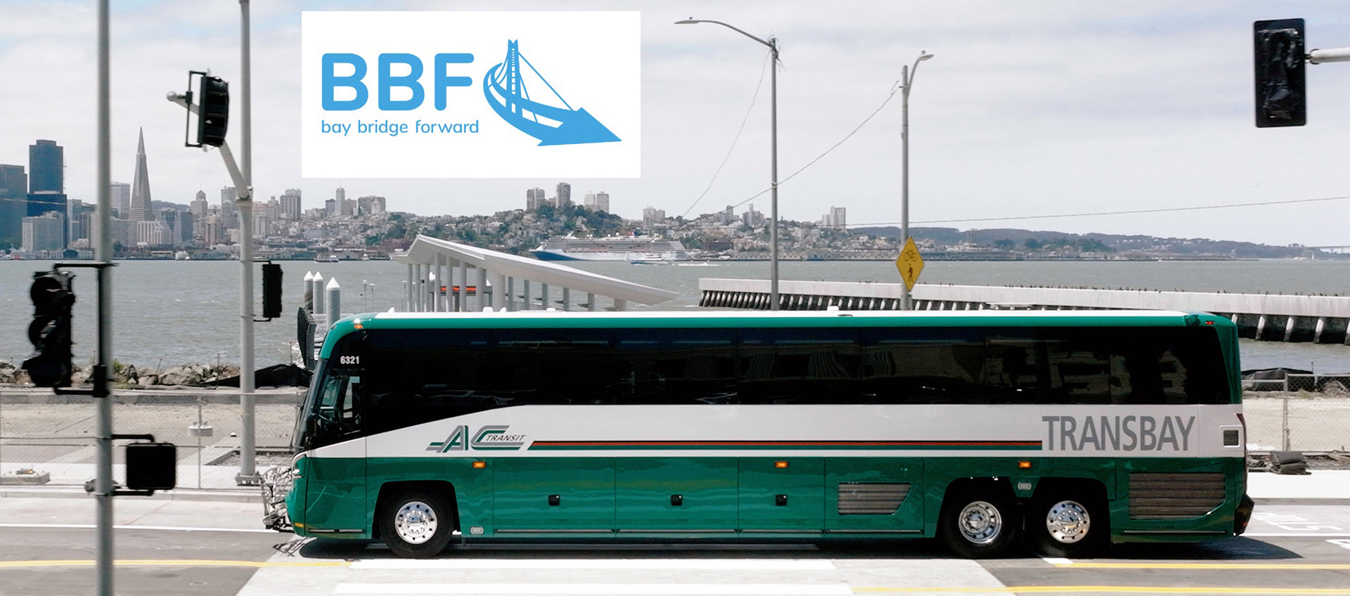
Photo: AC Transit

Project 5 – Smart Transbay Transit

The Bay Bridge Forward’s Smart Transbay Transit project aims to deliver near-term Intelligent Transportation Systems (ITS) enhancements.

  • Project Overview

The Smart Transbay Transit project is split into two phases. Phase one, now complete, consisted of planning and analysis. A future phase two will include technical design.

In phase one, MTC collaborated with Contra Costa Transportation Authority, WestCat, AC Transit, Alameda County Transportation Commission  and local cities in the East Bay.

The goals of the first phase were to:

  • Assess current transbay bus operations;
  • Analyze strategies to improve transbay bus service; and
  • Define preferred corridors and concepts for project development.

The first phase recommended the implementation of Transit Signal Priority and traffic signal enhancements to select corridors. Traveler information strategies were also assessed.

  • Project Schedule

Planning and Analysis were completed in Spring 2026, and the estimated completion dates for Technical Design is in 2027 and Implementation in 2027-28.

View the expanded Bay Bridge Forward Projects Map.

Filed Under: Construction, East Bay, News, Transportation

Bay Skyway to connect Bay Bridge East Span Path to Treasure Island, San Francisco

September 12, 2026 By Publisher Leave a Comment

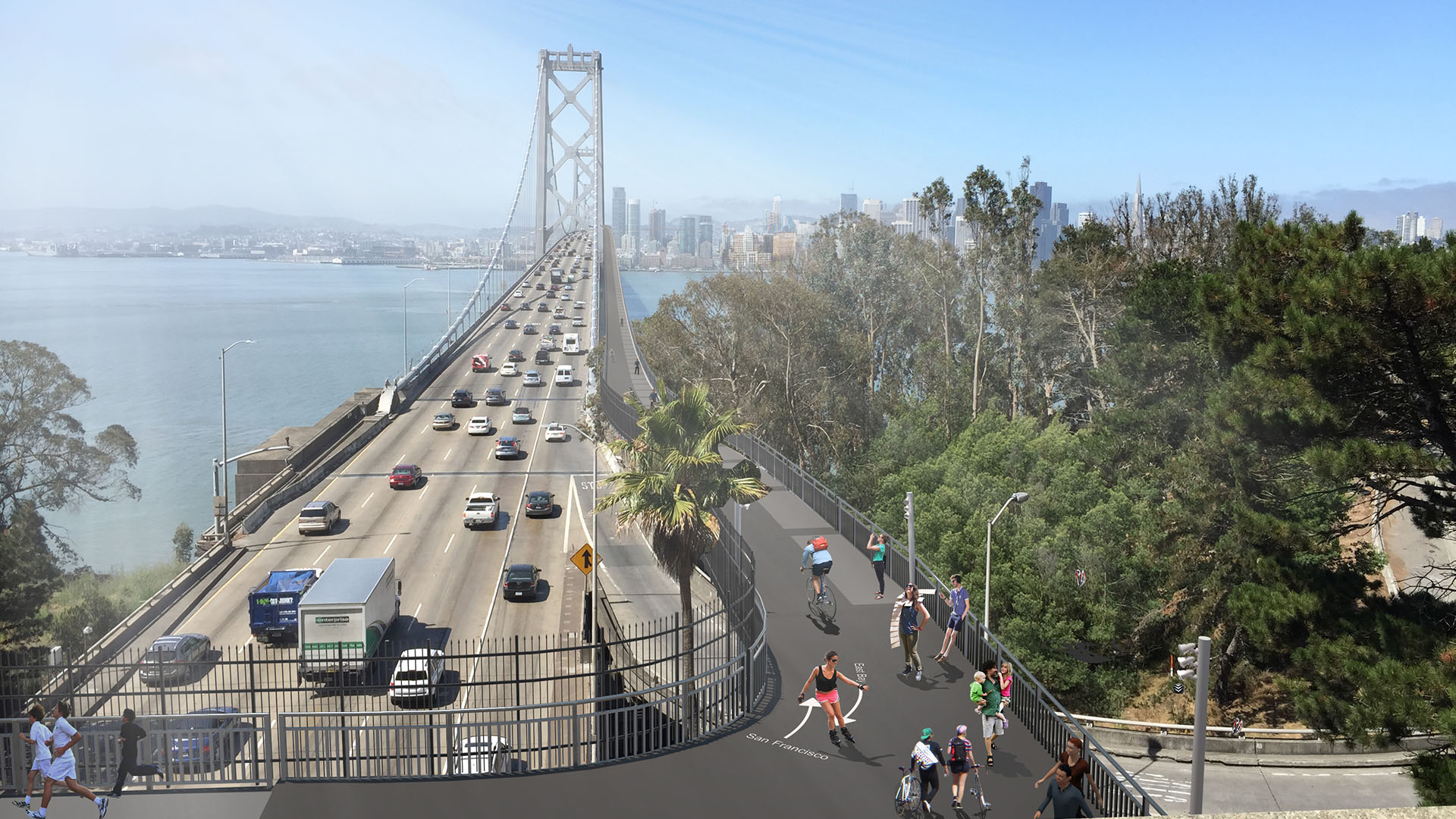
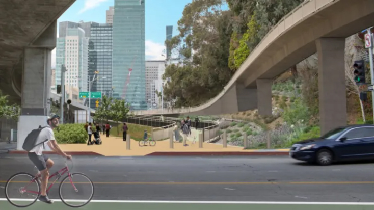
Rendering of the planned Bay Skyway for the western span of the Bay Bridge. Source: MTC

A New Way to Cross the Bay

By Gavin Lohry, Bay Skyway Program Coordinator, Metropolitan Transportation Commission

A team is working to extend both ends of the San Francisco-Oakland Bay Bridge East Span Path into a broader network called the “Bay Skyway” that will link Oakland and the greater East Bay with Treasure Island and downtown San Francisco.

Every year, thousands of residents and visitors enjoy the path on the East Span of the Bay Bridge, a 15-foot-wide walking and biking path with panoramic views of San Francisco Bay. The path joins Berkeley and Emeryville with Yerba Buena Island with a bus connection and private ferry service to downtown San Francisco. The Bay Skyway project will extend the path in both directions, linking Oakland and the greater East Bay with Treasure Island and downtown San Francisco.

Building the Complete Bay Bridge Path

Creating the complete car-free path between San Francisco and the East Bay will take several significant steps.

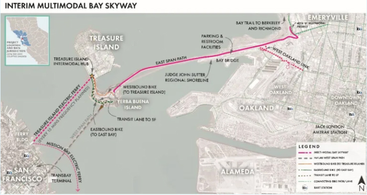
Work on the first piece of the puzzle – known as the Multimodal Bay Skyway – is already underway and expected to be complete by 2031. It will connect the West Oakland Community all the way to Treasure Island. This part of the project is called multimodal because the final connection for the full journey to San Francisco will require taking transit (bus or ferry) from Treasure Island to downtown San Francisco.

The second piece of the puzzle – a bicycle/pedestrian path on the West Span of the San Francisco-Oakland Bay Bridge – is in the early planning stages.

Source: MTC

About the Bay Skyway

The Multimodal Bay Skyway is made up of two key projects—the Full West Oakland Link and the Full Yerba Buena Island Multi-Use Pathway—which together will extend both ends of the existing San Francisco-Oakland Bay Bridge East Span Path. Both projects are currently in the design phase with initial segments planned to open by 2029.

  1. The West Oakland Link will extend the east end of the East Span path further to the east by constructing the missing connection to West Oakland, connecting with planned protected bike lanes on Grand Avenue to Downtown Oakland.
  2. The Yerba Buena Island Multi-Use Pathway will extend the East Span path west to the Treasure Island intermodal hub. From there, travelers will be able to take a ferry or expedited bus into downtown San Francisco.
    • The electric ferry will connect Treasure Island and the San Francisco Ferry Building, with plans to extend service to Mission Bay in the future. Frequent electric ferry service intervals of 15-minute are not expected until 2030 or later.
    • Buses will operate on a new one-way bus-only lane and on ramp between Treasure Island and the Bay Bridge West Span that will decrease bus travel time to downtown San Francisco.

Part of Bay Trail

The Bay Skyway is a critical section of the San Francisco Bay Trail which, when complete, will give hikers, joggers, bicyclists, skaters and wheelchair users access to more than 500 miles of trails encircling the bay. With the rapid adoption of electric bicycles (e-bikes), the Bay Skyway will also provide an alternative for Bay Area residents to cross the Bay without adding to roadway or transit congestion.

Benefits

  • Sustainability: Adds a new sustainable and low-cost travel mode along the Bay Bridge corridor, increasing capacity without increasing vehicle miles traveled (VMT), greenhouse gas emissions or air pollution. By connecting a Transbay pathway with an electric ferry network, the project supports car-free development and enables new Treasure Island residents to establish sustainable transportation options starting on move-in day.
  • Access: Provides a connection for bicycle/e-bike/micromobility users going between San Francisco and Oakland, which are two cities with the lowest car ownership rates in California. It also provides 20,000 future residents of Treasure Island with improved transit and bicycle access to the East Bay and regional rail such as BART, Capitol Corridor and Amtrak.
  • Equity Priority Communities: The Bay Skyway will provide access to high-quality jobs at the Port of Oakland and in downtown San Francisco, while providing an affordable transportation option for residents of equity priority communities on both sides of the Bay.
  • Car-Free Housing: In the next decade, significant housing developments are planned in the areas around downtown San Francisco and adjacent to the Multimodal Bay Skyway. Projects include 8,000 units on Treasure Island, 5,000 in West Oakland and 29,000 in downtown Oakland, including thousands of affordable homes.

Part of Plan Bay Area 2050+

The Bay Skyway is included in Plan Bay Area 2050+ as part of the “Build Complete Streets Network” strategy to promote walking, biking and small electric micromobility vehicles (such as e-scooters) throughout the Bay Area.

Source: MTC

Partnership

MTC, the Bay Area Toll Authority (BATA), Caltrans District 4, San Francisco County Transportation Authority (SFCTA), Treasure Island Mobility Management Agency (TIMMA), Alameda County Transportation Commission and San Francisco Bay Ferry are working on several projects in two phases to extend the path and connect downtown San Francisco and the East Bay.

Phase One

As of March 2026, about $100 million has been secured by MTC and SFCTA to construct the interim Multimodal Bay Skyway projects that include the interim West Oakland Link, the interim Yerba Buena Island Multi-Use Pathway and electric ferry charging infrastructure. The full buildout of the West Oakland Link and Yerba Buena Island Multi-Use Pathway will be completed when funding is secured.

Timeline

The Interim West Oakland Link (WOL) is in the detailed design phase with construction on the westernmost portion. In the near term, the project will rely on another MTC project — Bay Bridge Forward West Grand Avenue Bus and High Occupancy Vehicle Lane Phase 2 — to provide access sooner. The Bay Bridge Forward project includes the construction of a pedestrian and bicycle path connecting the eastern end of the WOL’s western touchdown and the West Grand Avenue/Mandela Parkway intersection. Construction of the Bay Bridge Forward path is expected to start and be completed in 2027. This path will not be impacted during the construction of the remaining portions of the interim WOL, which is anticipated to be completed by 2029. The full West Oakland Link will be constructed once funding is secured.

The Interim Yerba Buena Island Multi-Use Pathway (Interim YBI MUP) is currently under construction, expected to be complete in 2028, except for one section that includes a spiral loop ramp designed to connect the East Path landing with the Full YBI MUP.  Until funding is secured for the spiral loop ramp, westbound bicyclists will continue to use Macalla Road on improved protected bike lanes. Eastbound bicyclists will use the interim YBI MUP and a temporary connector at the location where the spiral loop ramp will be. Pedestrians will continue to use Macalla Road in both directions until the spiral loop ramp is built.

Electric ferry service is planned to begin in 2027 with connections to downtown San Francisco, and future service to Mission Bay is expected.

Source: MTC

Multimodal Bay Skyway Phase Two: Bay Bridge West Span

Bay Bridge West Span Path: Project Overview

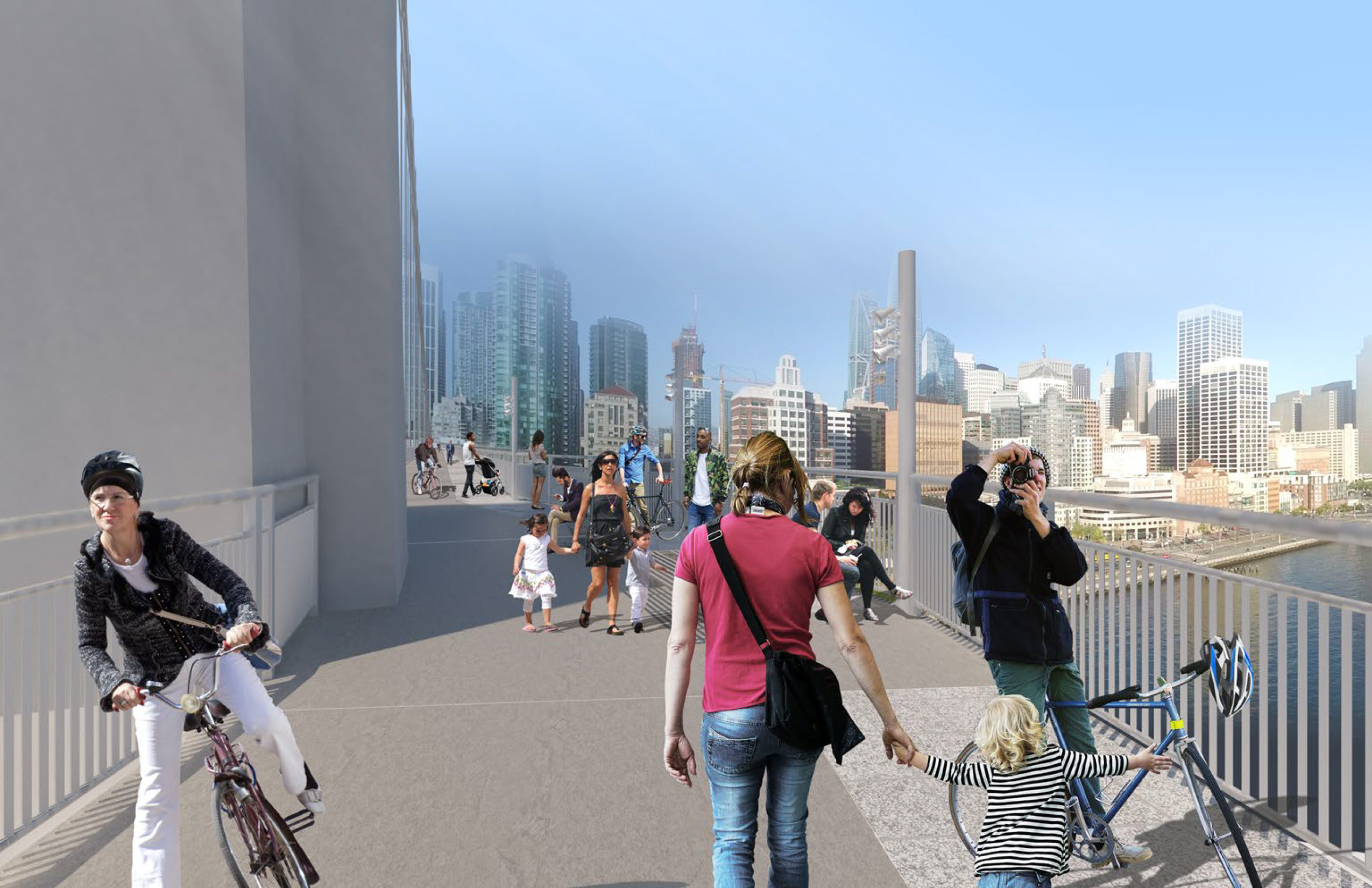
The Bay Skyway Phase Two project will construct a bicycle and pedestrian pathway on the Bay Bridge West Span, which will allow a continuous route to walk, bike and e-bike between the East Bay and downtown San Francisco. The path will have the capacity to carry 7,500 bicycle trips and 4,500 people walking per hour across the Bay.  This project will build upon the infrastructure developed through the Multimodal Bay Skyway, connecting the West Span path to thousands of new residents on Treasure Island, the existing Bay Bridge East Span path, and into Oakland via the West Oakland Link. The next major milestone is completing the State and Federal environmental analyses, which can be finalized as early as 2027.

The Bay Skyway will help shift transbay trips to biking, e-biking and other micromobility options. This will reduce congestion in the transbay corridor and reduce greenhouse gas emissions and air pollution while providing low-cost transportation options for Bay Area residents.

West Span Path Design

In 2018, alternative designs for a path on the Bay Bridge West Span were first presented to the public. As a result of this outreach and professional judgment, a design was chosen for a path on the north side of the bridge. This path will touch down on Essex Street in downtown San Francisco and on Yerba Buena Island, where it will connect to Treasure Island to the existing Bay Bridge East Span path via the Yerba Buena Island Multi-Use Pathway.

Source: MTC

Funding Challenges

The biggest challenge for the West Span Path project is securing funding. The cost is expected to be in the hundreds of millions of dollars, and no funding sources have been identified yet. State and Federal environmental analysis, the next step in the Phase 2 project, may be completed in 2027. If funding is secured, Phase 2 of the project could be completed as early as 2034.

Design Challenges

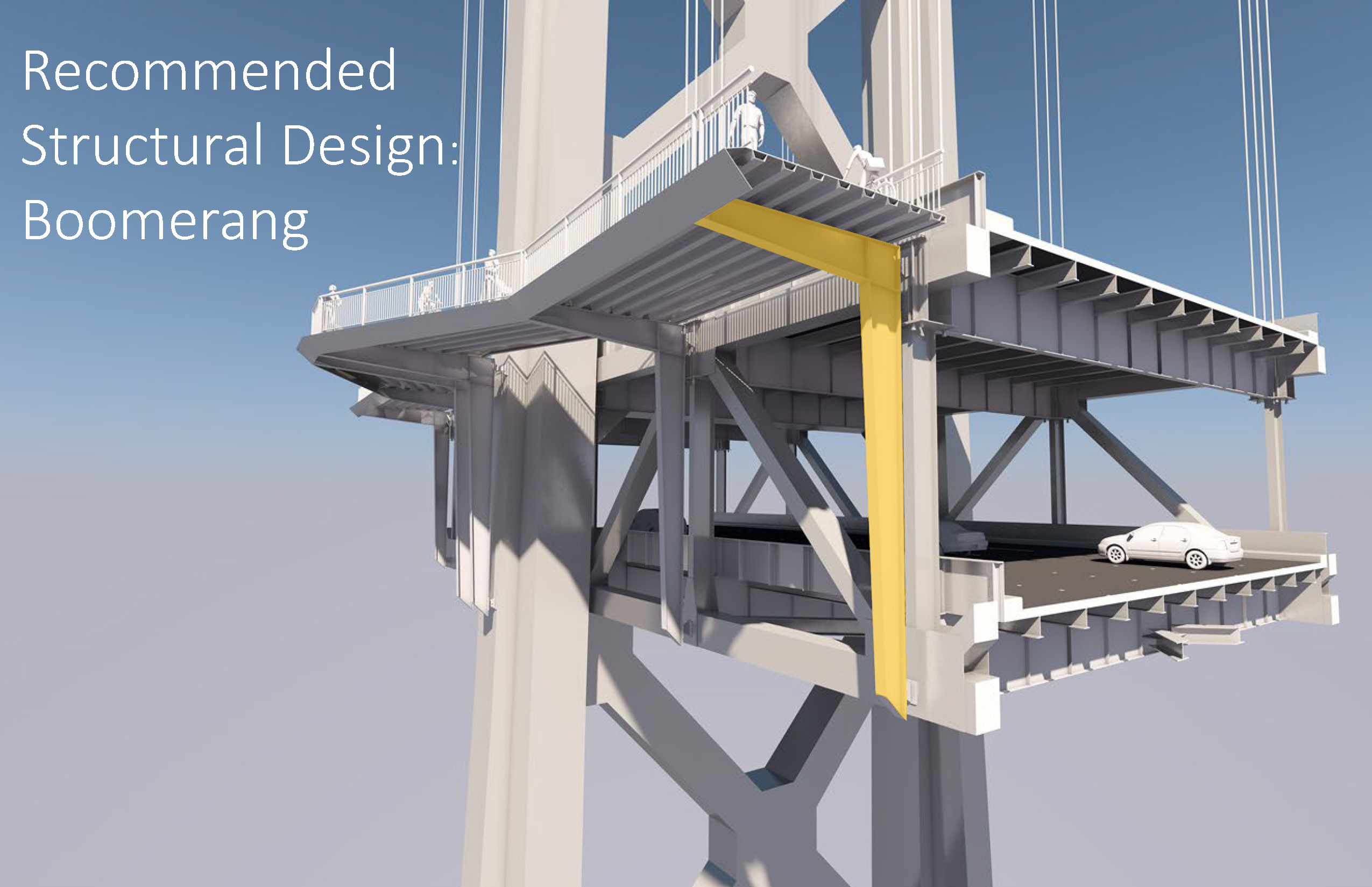
To move forward, the project must address several design issues including: safety during earthquakes, withstanding strong winds, providing access for maintenance crews, and maintaining enough clearance for shipping traffic.

Watch the video to learn more about the proposed West Span Path.

Take the Survey: Multimodal Bay Skyway Survey

Sign up for the Bay Skyway mailing list.

Filed Under: East Bay, News, Transportation

East Bay Regional Park District hosts Annual Coastal Cleanup Day Sept. 19

September 11, 2026 By Publisher Leave a Comment

Source: EBRPD

During 42nd Annual California Coastal Cleanup Day

OAKLAND, Calif. — Volunteers and East Bay Regional Park District staff will come together to clean and protect local shorelines and waterways during California Coastal Cleanup Day on Saturday, Sept. 19, from 9am to noon. The Park District is facilitating cleanup events at nine sites across Alameda and Contra Costa counties, including bayside beaches, shoreline trails, and inland lakes. Staff and volunteers will work together to collect and dispose of litter and recyclables, beautify the shorelines, and help maintain delicate ecosystems. At last year’s event, volunteers collected an estimated 9,295 pounds of trash from East Bay Regional Parks.

Volunteers are welcome in all locations listed below, although registration is appreciated. Sign up at ebparks.org/coastal-cleanup or call 510-544-2229 for more information.

Source: California Coastal Commission

Park District Coastal Cleanup Day Sites

Contra Costa County

  • Point Pinole Regional Shoreline, Giant Staging Area. More info.
  • Point Isabel Regional Shoreline, end of Rydin Road, Richmond. More info.
  • Radke Martinez Regional Shoreline, main parking lot off N. Court Street. More info.
  • Waterbird Regional Preserve, near the pavilion by the parking area, Martinez. More info.

Alameda County

  • Del Valle Regional Park, lakeside cleanups at the Visitor Center & Fiesta Grande Picnic Area. More info.
  • Robert W. Crown Regional Shoreline, near the Native Plant Garden and Bath House. More info.
  • Hayward Regional Shoreline, West Winton Avenue. More info.
  • Quarry Lakes Regional Recreation Area, Isherwood Way – Ensenada North Picnic Area. More info.
  • Martin Luther King Jr. Regional Shoreline, Arrowhead Marsh Staging Area. More info.

The Park District will provide garbage bags and gloves, and volunteers are welcome to bring their own additional trash-hunting gear such as long-handled grabber tools. Participants are encouraged to bring a refillable water bottle, hats, gloves, and sunscreen, and must wear closed-toe shoes. Layered clothing is recommended. The Park District will also provide snacks and water throughout the event. Please note that parent participation is required for children under 18.

Source: California Coastal Commission

Each year at Coastal Cleanup Day, volunteers discover unusual items during cleanup events. Past items include a boombox, statues of Ganesh and Shiva, a sparkly high heel, and a functioning 1980s-era ThighMaster. Participants who find an odd or interesting item will receive a Park District-themed cooling towel (while supplies last).

This year’s Coastal Cleanup Day also marks the 50th anniversary of California’s Coastal Act, the 1976 law that established a lasting commitment to protecting California’s coast and ensuring it remains accessible to everyone. Over the past 50 years, the Coastal Act has helped protect thousands of acres of open space and habitat, create public access to the coast, and open hundreds of miles of the California Coastal Trail. Coastal Cleanup Day is a chance for all to play a small part in caring for the land and ensuring it remains healthy and accessible for generations to come.

The East Bay Regional Park District is the largest regional park system in the nation, comprising 73 parks, 55 miles of shoreline, and over 1,330 miles of trails for hiking, biking, horseback riding, and environmental education. The Park District receives an estimated 30 million visits annually throughout Alameda and Contra Costa counties in the San Francisco Bay Area. www.ebparks.org

Filed Under: Community, East Bay, Environment, Parks

CHP targets Bay Bridge approach for stepped-up enforcement campaign

September 9, 2026 By Publisher Leave a Comment

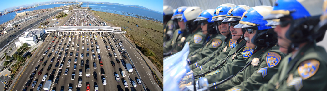
Photos: (Left) MTC (Right) Credit John Huseby, Caltrans

Carpools allowed in bus lane only during weekday peak periods

By Cindy Ramirez, CHP, Bart Ney, Caltrans and John Goodwin, Bay Area Toll Authority

SAN FRANCISCO, Sept. 9, 2026. . . The California Highway Patrol, in partnership with Caltrans and the Bay Area Toll Authority, this month will resume concentrated enforcement of the laws governing the westbound approach to the San Francisco-Oakland Bay Bridge. This includes strict enforcement of vehicle-type and vehicle-occupancy laws in the bus/carpool lane that bypasses the San Francisco-Oakland Bay Bridge toll plaza at the far-right side of the roadway.

This lane — which can be accessed by traffic approaching the bridge from Interstate 80, Interstate 880 or West Grand Avenue — may be used by buses, motorcycles or carpools with three or more occupants during the weekday commute periods of 5 a.m. to 10 a.m. and 3 p.m. to 7 p.m. Only buses may lawfully use the lane at other times, including all day on Saturdays and Sundays. Drivers cited for improper use of the bus/carpool lane outside weekday commute hours are subject to a fine of $490 or more.

“The signs at access points to the lane are clear and unambiguous. They read ‘Buses Only,’” noted Lt. Ed Clarke of the CHP’s Oakland Area. “But many drivers have not consistently followed the rule in recent years.” The CHP, Caltrans and BATA agree that focused enforcement will help address ongoing violations, improve compliance with the posted restrictions, and ensure the lane remains available for its intended use.

Acting Caltrans District 4 Director and BATA Commissioner Doanh Nguyen reminds drivers that the toll booths at the Bay Bridge and other state-owned toll bridges will soon be a thing of the past. “The transition to open-road tolling already is underway, with the new system set to debut next year at the Richmond-San Rafael Bridge. The comprehensive reconfiguration of the approaches to every state-owned toll bridge will improve safety and efficiency by allowing drivers to pay their tolls without having to slow down to squeeze past the obsolete toll booths.”

BATA administers all toll revenues from the region’s seven state-owned toll bridges. Caltrans owns and operates the state highway system, including state-owned toll bridges such as the Bay Bridge.

La Policía de Caminos de California (CHP) se enfoca en el acceso al puente Bay Bridge para una campaña de reforzar el control

Los vehículos compartidos solo pueden circular por el carril de autobuses durante las horas pico de los días laborables

SAN FRANCISCO, 9 de septiembre de 2026. . . La Policía de Caminos de California (CHP), en colaboración con Caltrans y la Autoridad de Peajes del Área de la Bahía, reanudará este mes la aplicación intensiva de las leyes que rigen el acceso en dirección oeste al puente San Francisco-Oakland Bay Bridge. Esto incluye la aplicación estricta de las leyes sobre el tipo y la ocupación de vehículos en el carril para autobuses y vehículos compartidos que evita la plaza de cobro del puente San Francisco-Oakland Bay Bridge por el lado extremo derecho de la carretera.

Este carril — al que pueden acceder los vehículos que se acercan al puente desde la Interestatal 80, la Interestatal 880 o West Grand Avenue — puede ser utilizado por autobuses, motocicletas o vehículos compartidos con tres o más ocupantes durante días laborables en los horarios pico de 5 a.m. a 10 a.m. y 3 p.m. a 7 p.m. Solo los autobuses pueden utilizar el carril en otros momentos legalmente, incluyendo todo el día los sábados y domingos. Los conductores

que reciban una infracción por el uso indebido del carril para autobuses y vehículos compartidos fuera de los horarios pico de los días laborables están sujetos a una multa de $490 o más.

“Las señales en los puntos de acceso al carril son claras e inequívocas. Dicen ‘Solo autobuses’,” señaló el teniente Ed Clarke del Área de Oakland de la CHP. “Sin embargo, muchos conductores han omitido cumplir la norma de forma consistente en los últimos años.” La CHP, Caltrans y la BATA coinciden en que una aplicación rigurosa de la ley ayudará a abordar las infracciones continuas, mejorará el cumplimiento de las restricciones establecidas y garantizará que el carril siga disponible para el uso previsto.

El director interino del Distrito 4 de Caltrans y comisionado de la BATA, Doanh Nguyen, recuerda a los conductores que las casetas de cobro en el puente de la Bahía y otros puentes de cuota de propiedad estatal pronto pasarán a ser historia. “La transición al sistema de cobro de cuotas en carretera abierta ya está en marcha, y está previsto que el nuevo sistema entre en funcionamiento el próximo año en el puente Richmond-San Rafael. La reconfiguración integral de los accesos a todos los puentes de cuota de propiedad estatal mejorará la seguridad y la eficiencia, al permitir que los conductores paguen sus cuotas sin tener que reducir la velocidad para pasar por las casetas de cobro obsoletas.”

BATA administra los ingresos de peajes de los siete puentes de peaje de propiedad estatal en la región. Caltrans es propietario y opera el sistema de carreteras estatales, incluyendo los puentes de cuota de propiedad estatal como el puente Bay Bridge.

CHP 針對海灣大橋引道展開強化執法行動

共乘車輛僅在工作日高峰時段才允許使用公車道

舊金山,2026年9月9日—加州公路巡警(CHP)將聯合加州交通局(Caltrans)

和灣區收費管理局(BATA),於本月恢復對舊金山-奧克蘭海灣大橋(San Francisco-Oakland Bay Bridge)西向引道相關交通法規的集中執法。執法重點包括加強監管位於最右側、可繞過海灣大橋收費站的公車/共乘專用車道,以確保使用該車道的車輛類型及載客人數符合規定。

該車道可供從 80 號州際公路、880 號州際公路或 West Grand Avenue 駛向大橋的車輛進入。在工作日通勤時段的上午 5 點至 10 點及下午 3 點至 7 點,公車、摩托車或載有三人及以上的共乘車輛可以使用該車道。在其他時段(包括週六和週日全天),僅公車可合法使用該車道。在工作日通勤時段以外違規使用該公車/共乘車道,將面臨 490 美元或以上罰款。

「車道入口處的標誌清晰明確,上面寫著『僅限公車』(Buses Only),」CHP 奧克蘭分局的 Ed Clarke 中尉指出,「但近年來,許多駕駛者並未始終遵守這項規定。」CHP、Caltrans 和 BATA 一致認為,開展集中執法有助於解決持續發生的違規行為,提高駕駛者對現場標示限制的遵守程度,並確保該車道維持其原定用途。

Caltrans 第 4 區代理局長兼 BATA 委員 Doanh Nguyen 提醒駕駛者,海灣大橋及其他州屬收費橋樑的收費亭即將成為歷史。「向開放式道路收費(open-road tolling)系統轉型的工作已經展開,新系統預計將於明年在Richmond-San Rafael大橋上率先啟用。對所有州屬收費橋樑引道進行全面重新規劃與改造,將讓駕駛者無須減速、穿越老舊的收費亭即可繳納通行費,從而提升道路安全與通行效率。」

BATA負責管理本地區七座州屬收費大橋的所有通行費收入。Caltrans負責擁有和營運州級公路系統,其中包括海灣大橋等州屬收費大橋。


Filed Under: CHP, East Bay, News, Transportation

Delta Veterans Group to host Stand Up on the Delta in Antioch Sept. 11th

September 3, 2026 By Publisher Leave a Comment

Information & Resource Fair and Free Fishing Event

To learn more about the Delta Veterans Group visit deltaveteransgroup.org or follow them on www.facebook.com/DeltaVeteransGroup.

Filed Under: Community, East Bay, Homeless, News, Recreation, Veterans

BB guns prohibited in East Bay Regional Parks

August 26, 2026 By Publisher Leave a Comment

Some BB guns look like real guns. Photos: East Bay Regional Park District PD

By East Bay Regional Park District Police Department

BB guns can look incredibly similar to real firearms, especially from a distance or during a fast-moving situation. That makes it difficult for both the public and law enforcement officers to immediately tell whether someone is carrying a BB gun or a real rifle.

That uncertainty can quickly create a dangerous situation.

It’s also important to remember that East Bay Regional Park District Ordinance 38, Section 403.1 prohibits BB guns in East Bay Regional Parks.

Please leave BB guns and similar weapons at home when visiting our parks. Following park rules helps keep visitors, staff, and responding officers safe.

Filed Under: Crime, East Bay, News, Parks, Police

Coach Beam’s Legacy Foundation announces inaugural Service Awards to Pittsburg, Hayward high school coaches who leads with heart, purpose and community

August 13, 2026 By Publisher Leave a Comment

The Coach Beam Service Award inaugural winners are Coaches Virgil Hart and Charlie Ramirez. Sources: Photo collage – Alex Kith on X, Virgil Hart on X and (bottom far right) courtesy of CBLF.

Service Award established in memory of John Beam, beloved Oakland Football Coach and Educator

Honorable Mentions for Fremont, Concord coaches

By Tish Gallegos, Coach Beam’s Legacy Foundation

Oakland, CA (August 12, 2026) – Coach Beam’s Legacy Foundation has announced its two inaugural Bay Area winners of the Coach Beam Service Award. The foundation recognizes Virgil Hart, head football coach and women’s head basketball coach at Hayward High School, and Charlie Ramirez, head football coach at Pittsburg High School. The newly established award honors coaches who lead with heart, purpose and community to transform the lives of student-athletes. Coach Beam’s Legacy Foundation announced the 2026 winners during the Oakland Ballers baseball game at Raimondi Park in West Oakland.

“We hope this service award will allow Coach Hart and Coach Ramirez to continue focusing on helping their student athletes in a significant way,” said Monica Beam, co-founder of Coach Beam’s Legacy Foundation. “We recognize the great work they are doing in their communities and how they extend Coach Beam’s dedication to uplifting young people through sport and education and building lasting character.”

Coach Virgil Hart – Hayward High School

Coach Virgil Hart returned to his alma mater with a mission that extends far beyond football. In addition to serving as head football coach, Hart works as an academic and social-emotional counselor, allowing him to support students both on the field and throughout the school community.

Under his leadership, Hayward football has compiled a 20-10 record and a league championship, but Hart’s greatest impact can be seen in the relationships he builds with students. His program places a strong emphasis on academics, mental health, leadership, and personal growth. Student-athletes participate in year-round study halls supported by college tutors and math teachers, while the program uses NCAA academic tracking to help athletes prepare for college opportunities.

Hart also prioritizes mental wellness, partnering with graduate students in sports and performance psychology to work with athletes on resilience, mental toughness, and personal development. Perhaps most importantly, Hart creates a safe and supportive environment where students know they have an adult they can turn to.

“He is not simply focused on developing athletes; he is committed to developing well-rounded young people who are prepared for life’s challenges,” wrote one of Hart’s nominators.

Coach Charlie Ramirez – Pittsburg High School

Coach Charlie Ramirez, aka “Coach Ram”, has dedicated more than two decades to Pittsburg High School, first as a player and assistant coach and now as head football coach, teacher, and mentor.

His accomplishments on the field are extraordinary. Since becoming head coach, Ramirez has led Pittsburg football to a 36-0-7 record, multiple BVAL and NCS championships, a NorCal D1AA championship and a state championship game appearance.

But his greatest contribution is the culture he has created around those accomplishments.

Ramirez works closely with administrators, counselors, families, and student-athletes to ensure players are prepared academically and positioned for college opportunities. His program has significantly reduced the number of academically ineligible student-athletes and increased the varsity team’s GPA. The varsity program has also had zero academically ineligible players over the past three seasons.

His commitment extends into the community through civil rights advocacy, campus initiatives, youth coaching clinics, and opportunities that teach players leadership and civic responsibility.

“He protects, disciplines, advocates for, and loves them like family,” one recommender wrote.

Awards

The two Coach Beam Service Award winners will receive individual recognition with a $7,500 stipend and program support through a $5,000 grant for their athletic program. Awards are renewable for up to three years based on continued good standing.

Coach Beam’s Legacy Foundation’s nine-member selection committee also named two 2026 honorable mention coaches: Nathan Boyes, head women’s basketball coach at California School for the Deaf in Fremont, and Lanette Stanziano, cross-country and track and field coach at Concord High School. Each will receive a $1,500 donation to their programs.

The Coach Beam Service Award highlights coaches of all sports in Alameda and Contra Costa Counties in California, who create safe, supportive environments where student athletes can truly thrive. By celebrating those who lead with compassion and integrity, the Foundation ensures Coach Beam’s legacy of unwavering commitment continues for generations to come.

The next round of nominations will open in Spring 2027. Criteria include serving as a high school coach in Alameda or Contra Costa Counties, possessing a minimum of three years coaching experience, and demonstrating a commitment to mentorship, leadership, and community impact. To learn more, visit www.coachbeamslegacy.org/service-award.

Coach Beam’s Legacy Foundation operates under the fiscal sponsorship of The AthLife Foundation, a 501(c)3 non-profit organization dedicated to supporting student-athletes in promising communities across the country.

For more information about Coach Beam’s Legacy Foundation, its mission, and how to donate, visit www.coachbeamslegacy.org.

About Coach Beam’s Legacy Foundation: Founded in 2025, Coach Beam’s Legacy Foundation was established by the Beam family to honor the life, values, and lifelong service of Coach John Beam. The Foundation exists to ensure that his name, his work, and his unwavering commitment to uplifting others continues to live on and positively impact the community he loved. Rooted in Coach Beam’s belief in the transformative power of sport, the Foundation seeks to develop well-rounded student-athletes and the leaders of tomorrow by focusing on five core pillars: Leadership, Academics, Financial Literacy, Mental Health and Social Justice. Guided by his enduring words – “I believe in you so you can believe in yourself”– the Foundation strives to empower young people to realize their potential, strengthen their communities, and create meaningful, lasting change. Learn more at www.coachbeamslegacy.org. 

About The AthLife Foundation: Founded in 2010, The AthLife Foundation is a 501(c)(3) national nonprofit organization with a mission to ensure that every kid who plays can achieve lifelong success beyond sport. Through grant funding, training and industry leading resources, we help schools create a critical professional staff position in secondary education, called an Academic Athletic Coach. That Academic Athletic Coach works year-round to create high impact programming, taps into a student’s passion for their sport and drives holistic development. We’ve reached tens of thousands of student-athletes in schools across multiple states, strengthened by partnerships with organizations such as the Heisman Trophy Trust, Joe Moore Award and Foundation for Teamwork, NFL Foundation, New York Community Trust, St. Luke’s University Health Network, State of Connecticut, State of Pennsylvania, Under Armour Foundation, and many others. Learn more at athlifefoundation.org or join our professional network at 3ace.connectedcommunity.org.

Filed Under: East Bay, East County, Honors & Awards, News, People, Sports

Oakland man charged in Concord burglaries, theft ring

August 7, 2026 By Publisher Leave a Comment

The Contra Costa DA charged Wuillian Heriberto Cordova-Cubias with five felonies following his arrest in Oakland by Concord Police on Aug. 5, 2026. Video screenshots source: Concord PD

Has history of arrests; released from custody Thursday back in custody Friday

By Ted Asregadoo, PIO, Contra Costa County District Attorney’s Office

Martinez, California – An Oakland resident faces five felony charges for his role in an organized theft ring connected to a series of burglaries in Concord.

The charges stem from a series of burglaries that occurred in Concord between April and July 2026 located in the Ygnacio and Clayton Valley region. Concord Police found that an organized group of juveniles carried out around 37 burglaries in that area. Richmond Police arrested the juvenile suspects for vehicle theft in May, and a subsequent investigation revealed they were part of a fencing operation led by 37-year-old Wuillian Heriberto Cordova-Cubias. Fencing operations are a hallmark of organized theft rings, which buy stolen goods from thieves and resell them to the public.

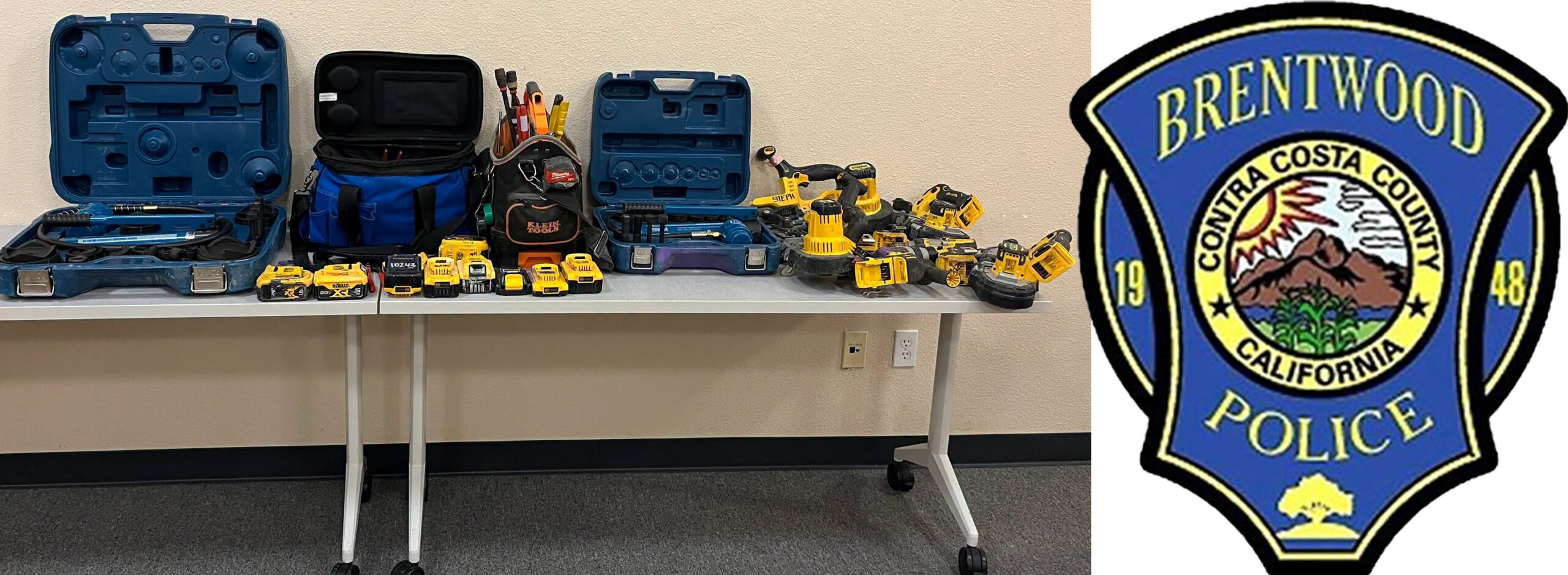
On August 5th law enforcement officers from the Concord Police Department, Oakland Police Department, and U.S. Marshals Service executed a search warrant at Cordova-Cubias’s Oakland residence. When officers entered the home, they located numerous items of suspected stolen property, including at least 500 power tools.  (See related article)

After law enforcement referred the case for review, the Contra Costa County District Attorney’s Office today filed a complaint in Superior Court against Cordova-Cubias. He faces the following charges:

  • Receiving stolen property, including power tools, survey equipment, motor vehicles, and pipe inspection equipment
  • Two counts of receiving stolen motor vehicles (a utility ATV and a forklift)
  • Unlawful firearm activity
  • Conspiracy to commit a crime with juvenile conspirators

All charges include enhancements that increase the potential penalties.

District Attorney Diana Becton said, “As organized theft offenses have increased, my office has responded by building an effective Organized Theft Unit that works closely with law enforcement to file strong cases we believe we can prove beyond a reasonable doubt in court. Concord Police Department’s thorough investigation into these burglaries and the fencing operation reflects the kind of collaboration that holds individuals accountable.”

Cordova-Cubias was in custody at the Martinez Detention Facility and will appear for arraignment in Contra Costa Superior Court in Martinez on August 10th at 1:30 pm. According to the Contra Costa County Sheriff’s Department, as of Thursday, Aug. 6, 2026, at 09:28 AM he had bonded out of custody. UPDATE: However, according to Asregadoo, he’s “not out of custody anymore. He was brought back in earlier today.”

According to localcrimenews.com, the five-foot, eight-inch tall, 240-pound Cordova-Cubias is Hispanic and has been arrested at least five other times for guns, drugs and violent crimes including battery and threats of violence, and receiving or concealing stolen property.

According to the Oakland Police, he was arrested in February 2020 “after a month-long investigation…charged…with possession of a firearm, possession of controlled substance, and possession of roughly 250 stolen power tools, worth an estimated $300,000. The suspect sold some of the items at flea markets in Oakland and San Jose.” (See video)

Case No. 01-26-04086 | The People of the State of California v. Wuillian Cordova-Cubias

Allen D. Payton contributed to this report.
Filed Under: Central County, Concord, Crime, District Attorney, East Bay, News

Max Korten promoted to East Bay Regional Park District General Manager

August 4, 2026 By Publisher Leave a Comment

Brings proven record of securing park funding, protecting land, and expanding public access

New General Manager Max Korten. Photo: EBRPD

OAKLAND, Calif. – Twenty-seven years ago, Max Korten was a young ranger in the Sierra Nevada, leading campfire talks for the U.S. Forest Service. Today, Tuesday, August 4, 2026, the East Bay Regional Park District Board of Directors voted 6-0 to appoint him General Manager, putting him at the helm of one of the largest regional park systems in the country. Korten has served as Acting General Manager since November 2025.

“Max has demonstrated steady, thoughtful leadership and a deep commitment to the East Bay Regional Park District’s mission, employees, and the communities we serve,” said Olivia Sanwong, president of the Board of Directors and representative for Ward 5. “The Board is confident that his experience, collaborative approach, and clear vision will guide the Park District forward as we expand access to nature, preserve our rich heritage of natural and cultural resources, provide meaningful environmental education, and ensure that an environmental ethic continues to guide all that we do. We are pleased to appoint him as general manager and look forward to continuing our work together.”

Korten joined the Park District as Deputy General Manager in October 2024. From the start, he worked closely with teams across the District to resolve challenges and build a more cohesive organization. Korten has worked diligently to build trust between the Board and staff through increased communication, transparency, and engagement. His accomplishments include collaborating with union leaders to reach an agreement on a new telework policy and working with neighboring city officials to preserve the historic Flag Barn in Brentwood. Korten is currently supporting staff and partners in efforts to reduce traffic on Del Valle Road in Livermore and is working with the Trust for Public Land, state leaders, and the cities of Berkeley and Albany on the potential acquisition of Golden Gate Fields.

Before joining the Park District, Korten spent 10 years at Marin County Parks, the last eight as director and general manager, leading an agency responsible for 34 open space preserves, 45 parks, and about 150 employees on a $35 million annual operating budget. He reported directly to the Marin County Board of Supervisors and worked with nine commissions and board-appointed committees.

During his tenure at Marin County Parks, Korten led the passage of the 2022 renewal of Measure A, the countywide sales tax that funds park maintenance, wildfire fuel reduction, farmland preservation, and public access, winning voter approval by about 75%. He also worked to eliminate park entrance fees, an initiative that aimed to expand equitable public access. He was also successful in passing a $20 million acquisition bond measure.

Looking ahead, Korten has prioritized aligning the Park District’s fire, stewardship, and operations teams around a cohesive vegetation management strategy. The effort includes mapping wildfire risk and habitat opportunities across the Park District for the first time. He is also leading development of District planning to support the Board in establishing shared goals and strategies to guide implementation in the years ahead.

“I’m honored and grateful for this opportunity, and I don’t take it lightly,” Korten said. “The Park District is a special place, and I’ve learned so much from the people who came before me. These parks are meant to be here forever, for everyone, and my focus is on keeping the organization strong so we can protect these resources while making sure they remain accessible and welcoming to all.”

Earlier in his career, Korten served as a wilderness ranger for the U.S. Forest Service, as natural resources program director for Conservation Corps North Bay, and as a backcountry ranger and trail crew supervisor for the Bureau of Land Management.

Korten holds a bachelor’s degree in environmental studies from the University of California, Santa Cruz, and a master’s degree in natural resources from Humboldt State University. He lives with his family in Berkeley, where he is a regular on the trails of Tilden Regional Park.

The East Bay Regional Park District is the largest regional park system in the nation, comprising 73 parks, 55 miles of shoreline, and over 1,330 miles of trails for hiking, biking, horseback riding, and environmental education. The Park District receives an estimated 30 million visits annually throughout Alameda and Contra Costa counties in the San Francisco Bay Area.


Filed Under: East Bay, News, Parks, People

Contra Costa businesses receive support from Alameda County Board of Supervisors for ultra-light rail freight and transit system, underground utility “SuperGrid”

July 16, 2026 By Publisher 1 Comment

Renderings source: CyberTran International, Inc.

Richmond’s CyberTran International, Inc., EarthGrid, UC Berkeley’s PATH, San Ramon’s Manex announce major achievement signaling new era of freight rail innovation and development, East Bay job creation

Richmond, CA – The Alameda County Board of Supervisors on Tuesday, July 14, 2026, officially and unanimously adopted a resolution in support of moving freight through the county using Richmond-based CyberTran International’s Ultra-Light Rail Freight and Transit (ULRF&T) system. The ULRF&T system is planned to operate from Oakland to the Central Valley via underground tunnels, and create a next-generation SuperGrid for underground utilities.

The development partnership includes CyberTran International, Richmond-based EarthGrid, U.C. Berkeley Partners in Advanced Transportation Technology (PATH), located at the Richmond Field Station, and the San Ramon-based Corporation for Manufacturing Excellence (Manex).

“Adoption…demonstrates…support for continued exploration and development of the Ultra-Light Rail Freight and Transit system, associated underground infrastructure improvements, and the establishment of advanced manufacturing and Inland Port facilities that could provide long-term transportation, environmental, and economic benefits to the East Bay region.” – Supervisor Nate Miley

Alameda County Supervisor Nate Miley has been a leading advocate for this effort. According to his staff report for the agenda item, #46, “The proposed ULRF&T system is intended to provide a lower-cost, zero-carbon alternative to conventional freight and transit rail systems while reducing truck traffic along the heavily congested Interstate 580 corridor. EarthGrid’s proposed underground SuperGrid technology would provide tunnel infrastructure capable of supporting both freight transportation and modernized utility corridors, while PATH contributes expertise in autonomous vehicle technology. MANEX would assist CyberTran in establishing a manufacturing facility within Alameda County, creating local jobs and supporting advanced manufacturing in the East Bay. As part of this initiative, CyberTran and its partners are also proposing the development of an Inland Port in eastern Alameda County to facilitate the movement of goods between the Port of Oakland and California’s Central Valley.”

“Adoption of the attached resolution demonstrates the County’s support for continued exploration and development of the Ultra-Light Rail Freight and Transit system, associated underground infrastructure improvements, and the establishment of advanced manufacturing and Inland Port facilities that could provide long-term transportation, environmental, and economic benefits to the East Bay region,” the staff report concludes.

Miley made the motion to adopt the resolution, Board President David Haubert seconded the motion, and it passed on a vote of 5-0. (See AlCo BOS CyberTran Resolution 071426)

“Automobiles have evolved, aviation has evolved, aerospace has evolved, it’s time for rail to evolve. Plus, roving blackouts and wildfires along with tomorrow’s energy and water needs dictate that it’s time to upgrade our outdated utility grid,” said Dexter Vizinau, CEO of CyberTran International.

Key Highlights of the Resolution

  • The initiative seeks to establish a Public Private Partnership Pilot Project.
  • The project will focus on developing and deploying an innovative autonomous rail system designed to efficiently transport freight, reduce costs, and decrease travel times compared to traditional trucking methods.
  • The County’s resolution also supports UC Berkeley PATH’s work to research, develop, and implement an autonomous ULRF&T system.
  • EarthGrid’s plasma boring technology is endorsed for tunnel construction, which will form a SuperGrid for utilities and facilitate the ULRF&T transit network.
  • Manex is supported in creating a CyberTran factory in Alameda County to manufacture and distribute ULRF&T systems globally.
  • This initiative is expected to reduce traffic congestion, particularly along the Highway 580 Corridor.
  • Thousands of well-paying jobs are anticipated for Alameda County residents because of the project.
  • By lessening truck traffic and congestion, the county aims to reduce negative environmental impacts.

Commitment to East Bay Community

The companies and organizations involved have a long history of fostering innovation and supporting skilled individuals, organizations, and businesses. Their strong ties to Alameda and Contra Costa County demonstrate their dedication to quality, creativity and integrity. (See related articles here, here and here)

(See 2:01:30 mark of Board meeting video)

Allen D. Payton contributed to this report.
Note: The publisher of the Herald has a financial interest in CyberTran International, Inc.

Filed Under: Business, East Bay, News, San Ramon Valley, Technology, Transportation, West County

  • 1
  • 2
  • 3
  • …
  • 9
  • Next Page »
RepublicServices-Antioch-ad (1)
Monica's Riverview 09-26 A (1)
Celia's-09-26B
Delta-RC-B 07-26
Deer-Valley-Chiro-06-22

Copyright © 2026 · · Contra Costa Herald · All Rights Reserved