Rendering of a CyberTran transit station. Renderings courtesy of CyberTran International, Inc.
Ultra-Light Rail Transit system vehicles travel throughout connected rail networks at low, medium and high speeds, direct to destination and at much lower capital deployment and maintenance costs
CONTRA COSTA COUNTY, CA – CyberTran International, Inc. (CTI) offers the most innovative approach to solving the world’s traffic congestion problems. The recent patent approval for fixed guideway transportation systems, with lower cost of ownership and optimized benefits, validates what they’re calling the Transportation Internet technology. This system can be thought of as the computer-controlled technology solution to the problems of mass transit cost overruns and inefficiency.
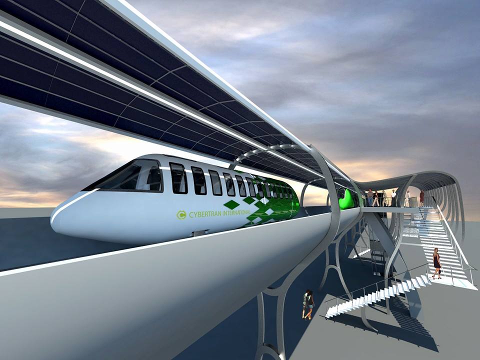
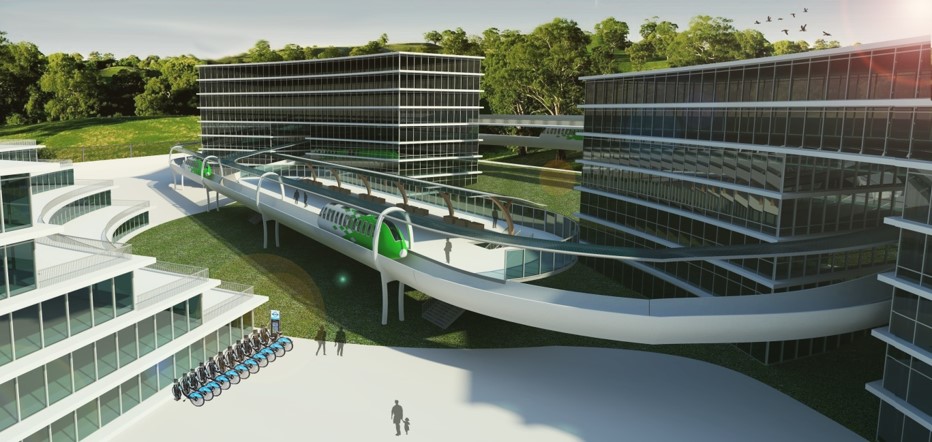
Artist rendering of a CyberTran vehicle and station with overhead solar panels generating the power to operate the system.
CTI’s Ultra-Light Rail Transit (ULRT) is a mass transit system with the ability to build out Urban Circulator systems, Commuter Rail systems and High-Speed Rail systems and connect them to one network where small rail vehicles carrying up to thirty passengers can travel throughout the network Direct-to-Destination (nonstop). This allows ULRT to serve three separate markets, low, medium and high speeds! Until today all three markets have been served by three separate distinct technologies that can only be connected at transfer points where passengers have to disembark one system only to transfer to another to reach their destination.
Currently, CTI is closing in on funding for the purpose of demonstration and deployment. “Everybody wants to be second, nobody wants to be first,” said Dexter Vizinau, President of CTI.
Transit officials are hesitant to take a chance on a small and innovative company. The BART system started out as a demonstration project and the technology was the first of its kind. Today, CTI has approximately ten cities that are willing to be first, he explained.
In every major metropolitan region of the world, people are stuck in traffic. Today’s solutions aren’t working.
“Expanding today’s transit systems are too costly to build and maintain, yet transit officials continue to approach this as a solution, with little result,” said Neil Sinclair, CTI Board Chairman. “There’s a $78 billion backlog in transit systems maintenance in the U.S. and the only way to pay for it is to raise taxes. In the meantime, we’re all stuck in traffic with no end in sight.” That is, until today.
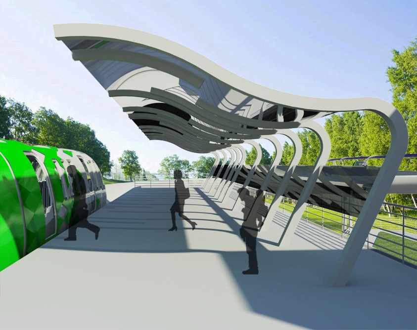
Overview rendering of the offline CyberTran stations.
“Our patent validates everything we’ve already proven,” Vizinau continued. “Two full-scale prototype vehicles have already been built and tested. The test vehicles have achieved speeds of up to 60 mph and have climbed a 10% grade, which means ULRT can go over the Sepulveda Pass in Los Angeles and also travel up the Grapevine Summit in Southern California. Bullet train systems and L.A. Metro-like systems cannot climb steep grades and therefore either have to tunnel or go around.”
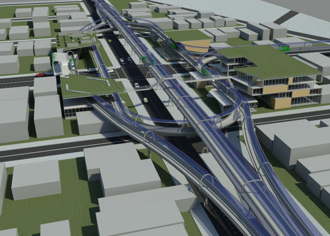
By building out ULRT networks in cities at 35 mph, and then connecting them together throughout a region at 80 mph, ULRT becomes a commuter rail system like BART and Metro in Los Angeles. ULRT can handle the same throughput as BART during rush hour via the Transbay Tube. CTI can then connect regions with a high-speed line. The ULRT System design is flexible and can expand easily. Guideways and civil structures are manufactured offsite and assembled onsite allowing ULRT systems to be constructed more efficiently. CTI can construct long-distance systems in up to a quarter mile per day. The system was designed to reach speeds of up to 150 mph. (See related article)
CyberTran’s ULRT system also operates from solar power. Canopies of solar panels above the guideway can generate more than one megawatt per mile and eight times more energy than the system consumes, and supply renewable energy to surrounding communities resulting in a net gain to CTI.
Rendering of a possible CyberTran station on the second floor of an office building and campus.
Transit officials currently purchase transit systems from foreign companies. CTI plans to manufacture ULRT transit systems for a global market in Contra Costa County. “We’ve been to China five times in as many years. There are six hundred cities in China that can use this,” says Sinclair. Councilmember Rich Kinney of the City of San Pablo states, “West Contra Costa County in particular has to solve the I-80 corridor congestion issue to attract more businesses and jobs to our cities. This is our opportunity to effectively address that issue. May we not continue to kick the proverbial can down the road – it’s time to embrace the full deployment of CyberTran right here at home.”
Earlier this year the city councils of Oakley, Brentwood and Antioch each voted unanimously to join the cities of Richmond and San Pablo to support efforts by CTI to obtain the needed funding for systems in both Western and Eastern Contra Costa County. (See related article) In addition, CTI has the support of U.C. Berkeley in their efforts to bring the technology to market. (See related article)
The next steps for CTI are to obtain funding to build two showrooms and a factory. This calls for one low-speed demonstration track up to 35 mph, and one rapid speed demonstration track up to 150 mph – in curves and with left and right banking. Both demo tracks and factory construction are to be done concurrently. There were no funding programs to support transit innovation, such as ULRT, at the federal level until CTI lobbied Congress to create one. Program legislation was created and approved in 2014 under a Republican-controlled Congress and Senate. CTI was hopeful that President Obama would release the program funding but it did not happen. CTI is hopeful about the President Trump’s infrastructure package and is encouraged by their reception in Washington, D.C.
Note: The publisher of the Contra Costa Herald has a financial interest in CyberTran International.