 THIS IS NOT AN EVACUATION ORDER. There are NO active evacuations in Contra Costa County at this time for the upcoming wind-driven fire weather event occurring beginning today and extending into Monday and Tuesday.
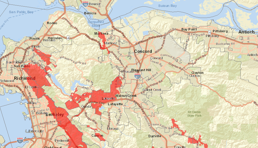
However, you may want to consider relocating ahead of this event. If you are uncomfortable in your home given this fire weather event, and you have somewhere to go that is not in a Very High Fire Hazard Severity Zone or area susceptible to wildland fire (see map below and at http://bit.ly/CCCVeryHighFireZoneMap for details), you should consider relocating this afternoon. Relocation could be to a hotel or the residence of a friend or family member in an area outside of the local area being affected by the forecast fire weather.
All of Contra Costa County is under an NWS Red Flag Warning from Sunday evening through Monday morning. Additional fire weather and gusty winds are expected to affect our entire area Monday through Tuesday morning.
The fire weather we are forecast to experience will be significant. Any fire that starts will likely spread quickly.
Residents living in Very High Fire Hazard Severity Zones, areas of the wildland-urban interface, or areas with narrow streets and limited evacuation routes should ensure the following:
- Your cell phones are fully charged and notifications are enabled
- Your cell and home phones are all registered with the Community Warning System at www.cwsalerts.com – there is still time to do this
- Your car is parked facing out of your driveway
- You have determined alternate evacuation routes from your home to a safe area outside of the hills
- You have a plan — you are prepared and ready to go as soon as receiving an official evacuation order
During the fire season, and particularly in this time of heightened fire weather, you need to have a plan to evacuate in the event of a fire. Do not hesitate if you are instructed to evacuate by law enforcement, the fire department, or receive a CWS notification or order to evacuate.
For information on protecting your family, home and neighbors from wildfire – including how to plan for evacuation – read and download our Residents Guide to Wildfire Preparation and Evacuation at www.cccfpd.org.
Communities and hillside portions of El Sobrante and San Pablo, Kensington, East Richmond Heights, the El Cerrito Hills and the west hills of the City of Richmond:
Winds are expected to peak between 2 a.m. and 5 a.m. Monday morning with gusts of approximately 47 mph and sustained winds of 31 mph. These significant gusty winds and elevated sustained winds are forecast from 5 p.m. Sunday through Monday morning. Relative humidity is expected to fall to very low levels further increasing risk in these areas.
Martinez (west of Berrellesa Street) and Lafayette (north of Highway 24)
Conditions similar to those for West County above are expected to impact other Very High Fire Hazard Severity Zones.
THIS IS NOT AN EVACUATION ORDER. IF AN EVACUATION IS ORDERED NOTIFICATIONS WILL BE SENT THROUGH THE COMMUNITY WARNING SYSTEM (CWS).
We want you to be as prepared as possible given the severity of the forecast fire weather; we want all residents to have ample time to prepare.

Leave a Reply